


Remaining mild next few days but turning wetter and windier. Cooler, brighter but showery conditions from Friday, as polar maritime airmass moves in, with a risk of widespread overnight frost where skies clear.
The exceptionally mild weather so far this month continues today and tomorrow. Temperatures are running some 3 to 4 degrees Celsius above the average for February across England and Wales. However, a pattern change is on the way after mid-week, which will bring cooler air in from the west, which will bring temperatures down to around average from Friday.
Cooler polar maritime air spreading from the west later this week will bring temperatures back down to average after being well-above recently

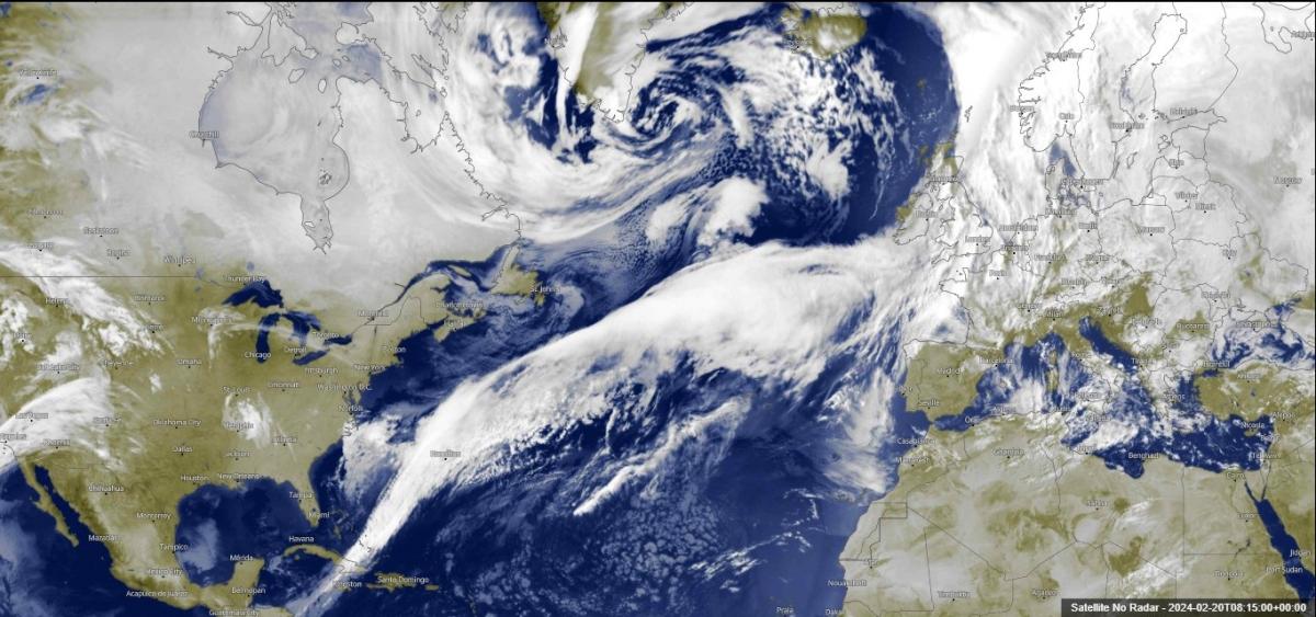
During this transition to cooler conditions, there will be a fair bit of rain to get through over the next few days. The culprit for all this rain will be a waving frontal boundary upstream over the North Atlantic. Impressively this frontal boundary can be seen stretching from near Iceland all the way southwest to past Cuba. Waves can be seen along the boundary and these will bring the spells of heavy rain across most places on Wednesday and Thursday.

Before the cooler air arrives, it will turn very wet over next few days, especially towards the west ...

This additional rain falling on already saturated ground will increase the risk of flooding in places, particularly across parts of England and Wales. There is also the potential for gales to develop too, especially on Thursday, with some models forming a low in a frontal wave that deepens as it crosses central areas, bringing gales towards the south.
So plenty going on over the next few days that may affect travel, already there’s a Met Office yellow warning for rain for SW England for Wednesday, but further warnings could be issued for the next few days. The worst of the rain and wind should clear east by Thursday evening. Following will be a cool and showery westerly flow, feeling colder in the wind than temperatures suggest.
It’s a mild start to the day again, it will be rather cloudy for most of England and Wales this morning ahead of a band of rain clearing southeast across Scotland and N. Ireland, cloud thick enough ahead of the rain band for some patchy light rain or drizzle across northern England, but most dry. As the rain band clears Scotland and N. Ireland through the morning, brighter skies will follow from the northwest, but also some heavy blustery showers moving into the far northwest. The band of rain will continue southeast across England and Wales through the afternoon and evening, tending to thin and weaken as it reaches the southeast. A rather mild day, temperatures reaching 12-14C generally.

The front bringing the rain band southeast today trails out west as it arrives in the south with a wave developing along the frontal boundary over the Atlantic pushing an area of rain back in across SW England and Wales this evening. As the wave develops into an area of low pressure moving northeast, winds will strengthen and rain will develop and spread more widely northeast across the UK and Ireland overnight after a dry start away from the southwest. Rain heavy across the north and west, with gales developing up through the Irish Sea. Wet for most by the end of the night.
A wet and windy start to Wednesday for many, rain heavy across the north and west. The rain and strong winds should clear east through the morning, clearing the east coast early afternoon followed by brighter but blustery conditions from the west, but with showers across western areas, drier and sunnier towards the east. A windy day wherever you are, with winds gusts to 40mph or more quite widely, gales across the far north of Scotland. Temperatures still on the mild side, 11-13C for most.
Rain could return from the west for a time along southern counties of England early Wednesday night before strengthening winds, perhaps gales developing, along with heavy and squally showers or longer spells of rain spreading in from the Atlantic across northern and western areas later in the night. This will lead into a squally and sometimes wet day on Thursday, as another frontal wave develops into an area of low pressure moving northeast across central areas, bringing outbreaks of heavy rain or heavy showers accompanied by strong gusty winds east across many areas during the morning, before clearing out into the North Sea during the afternoon. Brighter but showery conditions following. Northern Scotland probably escaping the wet weather in the morning. Turning cooler following the morning rain clearing, afternoon highs ranging between 6-8C in the north to 9-12C in the south.

Chillier day on Friday in the brisk westerly wind, but bright and showery, most of the showers across the west – where they will fall wintry over higher ground. With all parts under a polar maritime airmass and skies clearing overnight, there will likely be a widespread overnight frost developing Friday and Saturday nights, with a risk of icy patches on wet surfaces from recent rainfall.

The weekend is looking generally dry with lighter winds for many, though there is a risk of rain across the southwest and far south and showers affecting western areas.


.jpg?w=350)


.jpg?w=175)