


A look at the week ahead with a shift away from this mild southerly flow. Widespread wind and rain midweek, then cooler and showery from the west/northwest.
February 2024 has been astonishingly mild in the UK following the warmest January, on record, for the world (Copernicus). After a series of Atlantic fronts bring more rain midweek, the flow will veer to a relatively colder northwesterly for next weekend.
The top temperature on Sunday was 16.8C at Gosport, Hants with temperatures widely in double figures and well above the February average of 6 to 8C. Colder air will waver in from the north on Monday and Tuesday evening, again for Scotland later on Wednesday. Around the middle of the week, it will be wet and windy. It is not until later on Thursday when the very mild southerly flow is properly cleared out so that the cooler air can take hold. It will then be bright with showers from the west.
Along with this warm air, there has been plenty of rain. There are still many flood warnings and alerts over England (away from the far north) and flood alerts for parts of Wales with high river levels and sodden land. There are flooding concerns with travel disruption possible over the next few days, from rivers, surface water and in places, groundwater flooding as well.
‘Local flooding from rivers is probable across parts of the Midlands and S.England on Monday and continuing during Tuesday and Wednesday for parts of the S.England. Further local flooding from rivers and surface water is possible on Wednesday across parts of SW England and the West Midlands.’ Env Agency
Monday starts with an occluded front dangling down the North Sea across to the Severn Estuary with some heavier bursts of rain around The Wash. The band of rain continues its track southeastwards this morning, more patchy over the West Country but more of a distinct rainy spell for East Anglia. As this rainband clears away to the Netherlands, it leaves plenty of fine and sunny weather
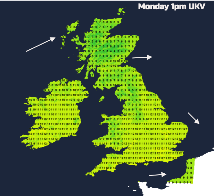
Temperatures will again rise to 10 to 15C with mostly light winds as high cloud increases over Ireland from the next frontal system. Warm front rain will reach the west coast of Scotland this evening as the southwesterly winds freshen. It will be mild again tonight across the UK, although a few spots in southern England will dip away with clear spells and light winds, down to 3C. The warm front dribbles its way across to the North Sea and much of the UK starts Tuesday in the cloudy warm sector air. Eastern Egnland could stay clear.

Tuesday
Southeastern Britain will hold onto the mild air, more cloud and southwesterly flow with temperatures in double figures. Where there are cloud breaks appear, temperatures could bump up to 15C. Way to the northwest, there will be cooler air with bright skies, sunshine and gradually, a rash of blustery showers for Scotland from the west. The showers will include some mountain snow, rain and hail. Current model timings show the frontal rain over NW England and Wales by mid-afternoon but the band weakens as it reaches southern England. With clear skies behind the cold front, temperatures will dip well down into single figures away from southern Britain. The frontal band in the south will then wave back northwards, the warm front bringing heavier rain over SW England and Wales in the small hours.

The frontal band will move over the Irish Sea and Northern Ireland as a brisk southerly flow takes hold by dawn on Wednesday. Timings may vary as we have a deepening low centre along a wavering frontal boundary. However, the themes for Wednesday are widespread rain, a brisk southerly wind, still mild in the morning but then a cold front clearance eastwards. That leaves drier and cooler conditions with a brief westerly wind.
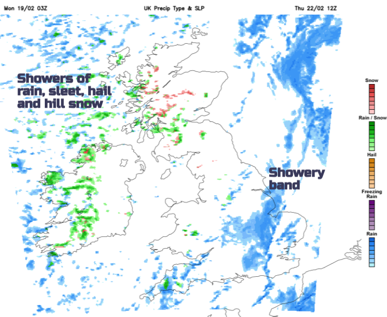
Thursday will see heavy downpours, some with hail and thunder, and then brighter gaps. Hefty showers will move in from the west with clusters of showers or bands of heavier rain. Don’t rely on Weather app timings at this stage, it will be a day for looking at the radar to see what is coming your way. By Thursday night, the showers will be turning wintry over hills. Friday will feel cooler but be bright with sunny spells and a scattering of showers, again some heavy and wintry.

So the mild air does hold on for the start of this week but with cooler air waving in and away from the north and west. Midweek sees a wet and windy spell and then the colder air does set in for the end of this week but things are only heading back to where they should be for this time of year.


.jpg?w=350)


.jpg?w=175)