The unusually mild February weather continues. Temperatures could hit 18C in the South today. But rain and flooding risks remain.
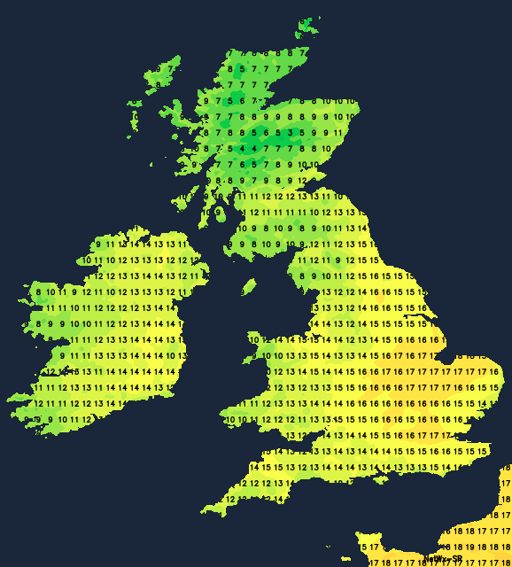
This February is on track to be one of the mildest on record. While unlikely to surpass our remarkable high of 21.2C from February 2019, temperatures today could easily reach 16C or 17C - perhaps even 18C in parts of the East and South East. However, conditions remain unsettled, and with already saturated ground, expect further flooding issues.
It's been an exceptionally mild start, especially across England and Wales, where temperatures stayed in double figures overnight. But the air is very moisture-laden, so it'll be mainly cloudy today. Eastern regions have the best chance of some watery sunshine. While much of the South has started dry, Northern Ireland, Scotland (excluding the East), and northern England face a soggy morning.
Expect patchy rain and drizzle throughout the day, though northern England will enjoy a brief lull before more rain arrives later. Wales and the South West will see heavier spells of rain, turning the weather misty with hill and coastal fog. This will all be driven by a fairly fresh southerly wind. Northern Ireland should brighten up later, though a few showers will remain. Top temperatures range from 13C to 16C, dropping to 9C to 12C across Scotland and likely only 6C in the very far North.
Rain will continue into the evening across England and Wales, heavy in places. Expect clearing conditions through the night, with broken skies arriving from the West and reaching most parts by morning.
Elsewhere, skies will be broken with scattered showers, some potentially heavy and lingering across Northern Ireland after evening rain clears the eastern parts of Scotland. Winds will shift westerly with the clearing weather but it remains mild: temperatures generally won't dip below 7C to 9C.
Friday should be brighter with sunny spells, but scattered showers remain. These will mostly affect the West, while sheltered central and eastern parts have a good chance of a dry day. Increasing cloud over Northern Ireland brings rain later, mainly hitting Tyrone and Fermanagh as another Atlantic front approaches from the southwest.
Temperatures remain very mild, though slightly cooler than today, thanks to a mostly moderate or fresh westerly, later southwesterly, wind. Expect highs of 11C to 13C in England and Wales, 8C to 10C further north.
Central and eastern areas should stay dry under broken skies, thanks to a ridge of high pressure. Eastern and northern Scotland might see a touch of frost, but overall temperatures shouldn't dip below 5C to 7C. Northern Ireland faces rain in a freshening southerly wind, spreading to other western areas by morning. Expect milder conditions here, around 8C or 9C.
Rain will spread from the West into the weekend, clearing to scattered showers. We might see a brief finer interlude early next week before unsettled, windy weather returns, though mild temperatures persist.