Sunshine will be at a premium over the next few days as cloudier, wetter and milder conditions affect many parts through to Friday, which should be drier and brighter. Could be very mild on Thursday, perhaps reaching 16C in eastern England.
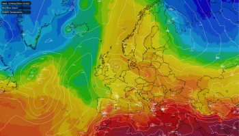
It’s been a sunny start to the week for many away from the northwest – where it was showery, but it will turn cloudier, wetter, windier and much milder through the rest of the week. An area of low pressure over the middle of the North Atlantic will slowly track towards northern Britain by late week. A fairly active westerly jet stream running across the British Isles ahead of it, with frontal boundary moving northeast too developing waves along it, bringing spells of rain northeast across many areas. But with the wind from the south or southwest, it will become rather mild, we could see temperatures reaching 16-17C on Thursday across eastern England.
Turning milder, very mild Thursday ...

... and wetter

For now, thickening cloud has spread in across much of England and Wales overnight, so a frost-free start, with outbreaks of rain moving in across SW England and south Wales, with some showers ahead of it across north Wales, northern and southern parts of England. A dry but chillier story further north across NE England, N. Ireland and Scotland, with a touch of frost in places where skies have cleared overnight, though heavy showers have continued overnight across NW Scotland, wintry over higher ground.

So, a chilly and bright start across northern areas, however, cloud with outbreaks of rain towards the southwest to start the day will spread northeast through the day, reaching northern England early afternoon, with a grey and damp afternoon across much of England and Wales. Rain heaviest across Wales and northern England. Scotland should stay mostly dry and sunny though, but some showers possible across the far north and western coasts. N. Ireland turning cloudier, with some rain reaching here southern counties. Highs of 11-12C across south Wales, Midlands, southern England and East Anglia; 6-9C further north.

Frontal system bringing today’s rain northeast will trail across N. Ireland and northern England, bringing a damp night here, while a frontal wave looks to move northeast across southern areas bringing a spell of rain further south too. Scotland escaping with a mostly dry night, chilly in the north.
Cloudy, breezy and mild on Wednesday, with outbreaks of rain spreading northeast from N. Ireland and northern England across Scotland through the day, turning to snow over the high parts of the Highlands as it bumps into cold air to the north. Bits of showery rain here and there further south across England and Wales. Though there could be some drier interludes. Far north of Scotland probably staying dry. Rather mild, temperatures reaching 11-14C across much of England, Wales and N. Ireland, perhaps 15C in a few spots, a cooler Scotland with 6-8C.
Another frontal system pushing up from the south Wednesday night into early Thursday across western and northern areas, bringing cloud and a spell of heavy rain here in the morning. Further heavy rain returning north across western areas in the afternoon. Rainfall more patchy across central, southern and eastern areas of England, perhaps staying dry towards SE England and East Anglia – where it could reach 16 or even 17C in the afternoon, especially if the sun comes out. But very mild for mid-February for all parts away from the far north, as southerly winds all the way from the western Mediterranean import warm air. Rain across the west clearing Thursday night.

Rain clearing the east first thing, then Friday is looking cooler and brighter, many staying dry with sunny spells, but the westerly wind will bring a few showers across western areas.
Saturday looking mostly dry and bright, but thickening cloud and rain arriving across the west by evening. Rain clearing east Saturday night, then it’s looking a mostly dry and bright or sunny Sunday as a ridge of high pressure builds.