A major Sudden Stratospheric Warming (SSW) took place on Wednesday. GFS analysis yesterday of zonal mean zonal winds at 10 hPa 60N showed -1.7m/s according to weatheriscool.com
However, there’s not been the usual fanfare in meteorological circles or more widely on media with this particular SSW, as the reversal of winds below 0 m/s at 10 hPa 60N has been brief, already the zonal mean zonal wind at 10 hPa 60N has turned back westerly today, albeit very weak, today's GFS analysis was 1.6 m/s. Forecasts show a quick bounce back to strengthening westerly winds to above average eventually. 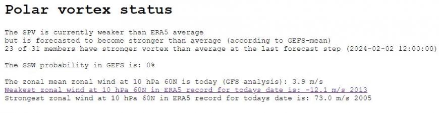
This likely accompanied by a recovery and strengthening of the Stratospheric Polar Vortex from its weakened state since December. The stratospheric polar vortex (SPV) currently displaced towards Scandinavia forecast to eventually move back to its usual home over the North Pole.
Back in December, just before Christmas, I wrote a blog about a possible Sudden Stratospheric Warming (SSW) in early January, which could “load the dice” in favour of cold and wintry weather in northern Europe including the UK in the New Year. This was based on a reversal being forecast by models earlier in January around 6th/7th. However, the reversal didn’t take place, so there was a ‘minor’ warming rather than a major one. However, this minor warming did couple with the troposphere and likely influenced the development of Greenland blocking / negative North Atlantic Oscillation regime over the past 7 days that brought cold easterly and now northerly winds to the UK.
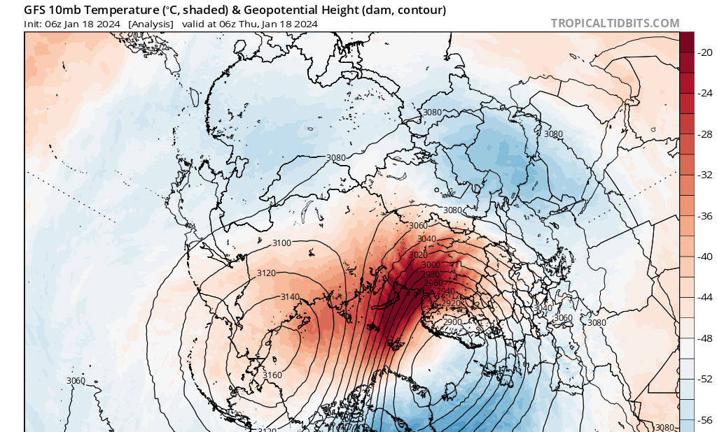
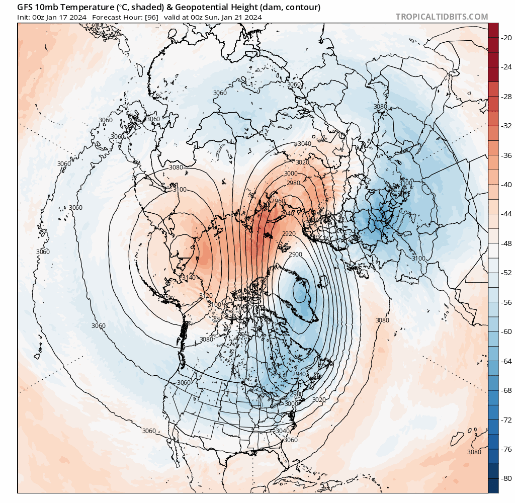
Since then, another warming attempt of the polar stratosphere has finally weakened the zonal (westerly) flow at 10 hPa 60N to bring a reversal of zonal winds to easterly yesterday (Wednesday 17th). There appears to have been three episodes of stratospheric warming since early December, looking at polar cap temperatures (below). The third warming, although classed as major SSW, doesn’t look to be particularly strong enough to completely weaken the SPV. It is weakened and displaced but looks to recover, unlike other major SSWs - where the SPV doesn’t recover for several weeks if at all.
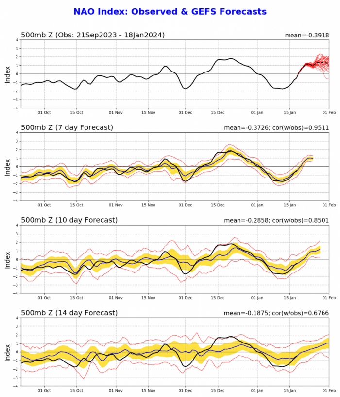
The increase in zonal winds as the stratospheric polar vortex looks just as dramatic, if not more, than the deceleration of zonal winds that led to the current SSW. The recovery of the SPV will mean there could be little impact of the brief SSW further down on the troposphere, where our weather happens. So, the average 2 out of 3 occasions that an SSW leads to high latitude blocking, a negative North Atlantic Oscillation and resultant higher likelihood of cold / wintry weather over Northern Europe a number of weeks looks unlikely this time.
Not all major SSWs produce weakening of the tropospheric polar vortex. SSW events can lead to different subsequent tropospheric responses. Studies show that, typically, the negative phase of the Arctic Oscillation (AO) or the surface signal of the Northern Annular Mode (NAM) tends to occur following an SSW or a weak stratospheric vortex event. However, this is not the case for all SSW events.
Following some past SSW events, a weakened polar vortex did not descend to the troposphere. The influence of a SSW on the troposphere differs considerably according to whether or not there is a split in the polar vortex or displacement, or whether or not a reflection occurs during the recovery phase of the SSW. With this particular event, it does look like wave reflection from upwelling waves from the troposphere, look to put a halt to any downwelling of easterly wind anomalies from the brief SSW.
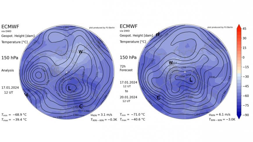
The SSW with reversal of winds to easterly at 10 hPa yesterday looks to be a result of a displacement of the upper stratospheric polar vortex towards Scandinavia. However, the lower part of the stratospheric polar vortex has seen a split looking at weather model analysis, likely due to upwelling waves from the troposphere rather than from above. This split in lower stratosphere, seen on the 150 hPa level below yesterday, has seen a ‘daughter’ vortex over Canada and larger vortex over Scandinavia. However, roll on to the 20th (Saturday) the ECMWF forecast shows the Canadian vortex has moved east and merged back with the larger vortex to be as one large displaced vortex over centred over Svalbard.
This pulling of the lower stratospheric vortex back together likely put an end to the recent Greenland blocking, brought by the minor warming of the stratosphere earlier in the month. The Greenland block has brought the northerly flow direct from the arctic this week, but the flow will ease on Friday, before it turns milder over the weekend.
So the major warming just occurred looks to actually work against sustained blocking forming, as the lower stratosphere organises back into one polar vortex which reflects down into the troposphere lowering heights across Greenland, far north Atlantic and Scandinavia – which will drive a strong zonal jet stream across the North Atlantic, with a return of mild, wet and windy weather over the weekend and into early next week.
Sudden change from a negative North Atlantic Oscillation (NAO), featuring Greenland block, to a positive NAO with upper vortex over Greenland, bringing unsettled, mild and windy weather
However, there are hints from tropospheric drivers, such as forcing by the passage of Madden Julian Oscillation into the Western Pacific could bring changes to upper flow in the northern hemisphere which could lead to blocking high pressure over Scandinavia at the end of this month or early February, which could bring a return of colder weather. But low confidence for now.
Loading recent activity...