
Another Atlantic depression will bring gales, heavy rain and hill snow in the north over the weekend, though it should turn drier and less windy Sunday evening to welcome in the New Year, though showers can't be ruled out.
We’ve had nearly everything the weather can throw at us but the kitchen sink this week, rain, damaging winds, ice, snow, hail and even a tornado in Manchester on Wednesday night. Only thing missing is a heatwave. The weather will remain unsettled and stormy with further spells of heavy rain and strong winds at times over the last weekend of 2023.
The first week of 2024 continues in a similar vein, with further areas of low pressure moving east off the Atlantic bringing further spells of rain or showers at times. But with the jet stream sinking south away from the UK through the week, the lows will be less deep so gales less likely than we have seen and will see over the weekend.
For now, continuing windy this afternoon across England and Wales, particularly across west Wales, northern and SW England, with gales possible over coasts and hills here. The strong westerly wind will drive areas of showers eastwards, but with some dry, bright or sunny spells in between. A more organised band of showers or longer spells of rain affecting N. Ireland, the Scottish Borders and far north of England through the day along a frontal boundary separating colder air to the north and milder air to the south. Temperatures reaching 8-11C.
Across most of Scotland, away from the far south, it’s a colder, drier and less windy picture, though there will be some wintry showers in the far north. Temperatures reaching 4-6C at best.

With a ridge of high pressure building in tonight, showers will generally fade and skies will clear to bring a colder night than of late, with temperatures falling into low single figures across England and Wales – which will allow a ground frost in places. Inland across Scotland temperatures falling below freezing to bring an air frost, perhaps as low as -7 to -8C in the Highlands.

A cold start to Saturday across northern and eastern areas, but across the west it will have clouded over and turned milder before dawn, with rain spreading in across SW England and Wales quickly spreading northeast across northern and western areas through the morning accompanied by strong winds, reaching the central belt of Scotland by lunchtime. Snow preceding the rain for a time across the hills of N. Ireland, the far north of England and Scotland, even to lower levels in Scotland, though settling snow confined to hills. Snow continuing into the afternoon across the Highlands and could affect major routes again through the area. Rain and hill snow will gradually clear northeast across northern areas through the afternoon, but more heavy rain will spread northeast along a trailing cold front across north across SW England, Wales and NW England into the evening.

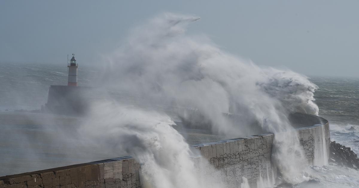
An active cold front with a band of heavy and squally rain with strong to gale force winds will then sweep east across England and Wales Saturday night, winds could gust 40-50mph widely, but with some gusts of up to 60mph as the squall passes through, maybe higher gusts along coasts of southern and southwest England. A yellow wind warning has been issued by the Met Office.

Yellow warnings are also in force for rain across Wales and Northern Ireland, with the cold front and rain before it bringing some large rainfall totals over the weekend falling on already saturated ground – so increasing the risk for flooding.
New Year’s Eve will see a weakening area of low pressure drift east from Ireland across to central areas of Britain through the day. This low will bring sunshine and scattered showers across England and Wales, locally heavy and thundery towards southern and western coasts, falling wintry over northern hills. Scotland looking drier and sunnier away from the far northeast. Windy towards southern and southwestern coasts. Looking mostly dry, chilly and breezy in the evening to welcome in the New Year, but could be a few showers blowing through in places too, so maybe worth taking a brolly if outdoors.

Further areas of low pressure moving west to east next week, but on a more southerly track as the jet stream starts to track further south. So longer spell of rain becoming more confined to southern Britain but showers could affect most places at times too through the week. Not as mild as recently and it will remain cold enough across Scotland for some sleet and snow from showers, especially over hills.
Looking further ahead there are signs it may eventually turn colder through the second week of January, with some weather models for a while hinting at a pattern change to bring blocking to the northwest, sending low pressure further south into mainland Europe while pulling in much colder air from the north or northeast. This change is not certain, as it’s being flagged at 9-10 days away, which is an unreliable timeframe to have confidence in.
An update on the Sudden Stratospheric Warming I highlighted earlier in the week, this now doesn’t look to occur now in early January as signalled for a while, with no reversal of 10 hPa zonal (westerly) winds at 60N to easterly that would technically be a SSW. However, there will still be a weakening of zonal winds causing a minor warming of the polar stratosphere which will mean a weak stratospheric polar vortex. This weakening and warming high up in the stratosphere could trickle down to the troposphere, where our weather happens, to bring an increased likelihood of high latitude blocking than can lead to cold and wintry weather for the UK and Europe. And this could be why the models are starting to show some blocking with colder conditions developing in the second week of January. We’ll keep you posted if this potential for much colder and possibly wintry weather looks more and more likely.


.jpg?w=350)

