


After a brief break on Boxing Day, Storm Gerrit has arrived, bringing high winds, heavy rain, and even some snow.
We have quite a change in the weather for Wednesday 27th, after a fine day for many on Boxing Day. Storm Gerrit has arrived with wind and rain, even snow for Scotland. This storm has been named by the UK Met Office to grab attention for the possible impacts from the midweek severe weather. There will be strong winds, heavy rain leading to flooding and coastal gales all with the potential to cause disruption as more people get on the move after the festive break.
If you have a train to catch, a car journey home, or live in an area with already saturated ground or on an exposed coast or hillside, then seeing “Storm Gerrit” will hopefully catch your eye today. You can then take in useful information and make informed decisions, maybe adapt your plans or just be ready for a bit of a delay.
The main concerns are disruption to travel, particularly as the railways return to full service (away from engineering works) and poor conditions on the roads. So slow down where there is surface water and spray. Also, delays or cancellations to some ferry services. The very strong winds could lead to fallen trees and power interruptions. The Met Office has a rash of warnings for wind, rain and northern hill snow.
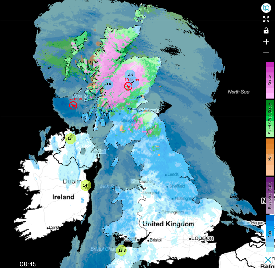
The frontal bands are already over much of Britain and Ireland before dawn. If you change to (Weather Type On) on the Netweather Radar you will see the areas of rain but also the green showing rain/snow mix and snow over the northern Pennines, Cheviots, Southern Uplands and inland Highland Scotland. Temperatures in northern Britain start the day around 3C, with southwest Britain and Northern Ireland at 8 to 11C in the warm sector air.
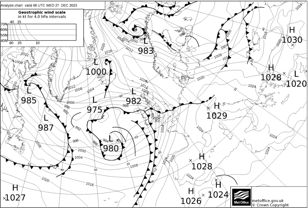
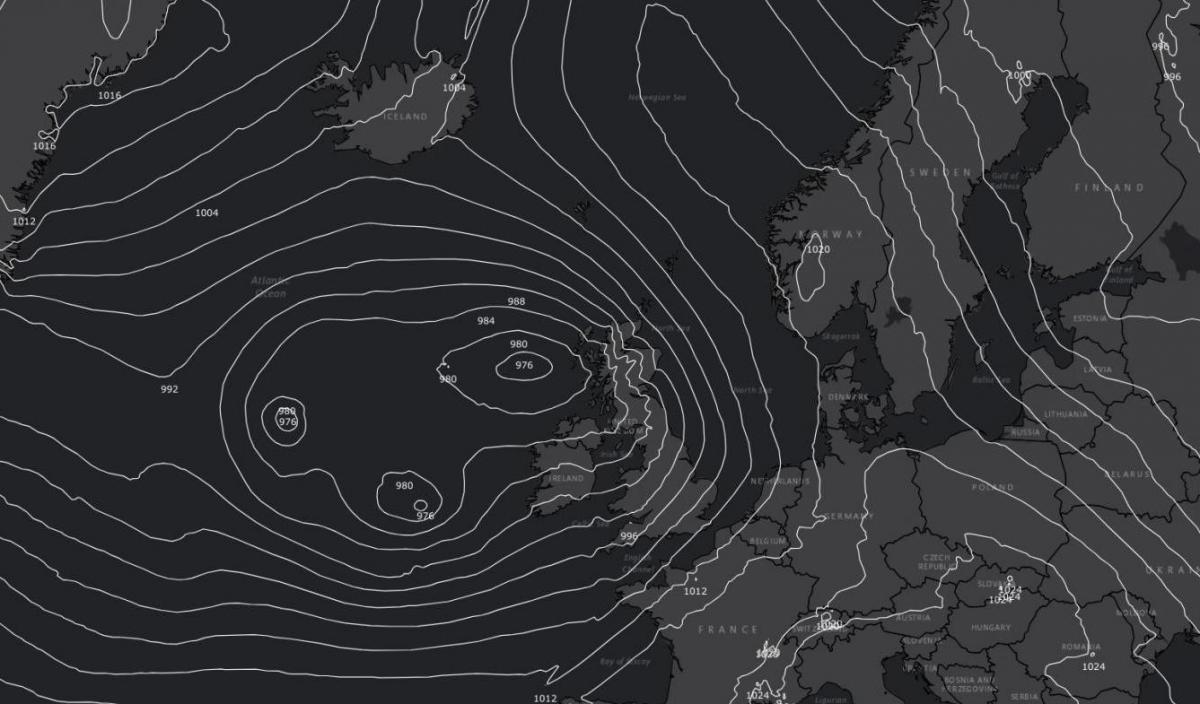
There is a collection of low centres within Storm Gerrit. One will run over northern Scotland during Wednesday as another passes over Ireland later in the day. The ‘Inshore Waters forecast’ mentions of storm force SE winds for northern Scotland with high seas and gales through the Irish Sea.
The strongest winds will be over the far north of mainland Scotland and the northern Isles by Wednesday afternoon, away from mainland Scotland by Wednesday evening and gradually confined to Shetland by midnight. A new tuck of gales then appears for SE Ireland across to Anglesey. Met Eireann also have weather warnings for strong winds and heavy rain with concerns for coastal flooding as all of this is combined with spring tides.
The frontal bands pivot over Scotland clearing for a time late morning from Northern Ireland with a cloudy lull for parts of England away from the southwest. Wales stays wet. Heavy outbreaks of rain will swing in from the west for Northern Ireland towards Scotland on the cold front with brighter skies for Ireland. Another area of rain will move from Wales and the West Country across southern England to East Anglia by mid afternoon. The main band of precipitation will be of rain for northern Britain and southern Scotland before lunchtime but continue to fall as snow over the mountains of Scotland and higher level routes. This wintry mix will reach Orkney by mid afternoon with the low centre over Fair Isle by midnight.
Behind the main fronts, clear spells and showers will follow with clusters and bands of sharp downpours.
The UKV model shows lively line convection overnight with torrential downpours and sudden gusty winds. These may wake you as they pass by. West coast Wales and Snowdonia look very windy up til midnight. Prepare for temporary horrible conditions on the roads if you are driving tonight. There could be snow over Pennine routes for a time from these clusters. It will be chilly for northern Britain with the risk of ice in places
Tomorrow will bring a fair but blustery start for eastern Britain but more heavy bands of sharp showers from the west. There will be hefty downpours of rain with hail and gusty winds moving in from the west. Again, sleet and snow for the NW Highlands as the showers arrive and move eastwards. Some parts of the UK will see fine sunshine and fewer showers but it stays windy. London will reach 12C and Edinburgh only 7C with the winds and gusts picking up on Thursday afternoon.
Do be prepared for a spell of very windy and wet weather midweek. The strongest winds hit Scotland this morning, strengthening over northern Scotland by lunchtime and raging into the afternoon and evening for the Northern Isles from the southeast then east. Southerly winds with coastal gales will affect the Irish Sea and Wales gradually reaching more of England this morning. It will be a windy afternoon with the winds veering slowly over England and Wales but another bout of strong winds (from the southwest) tonight and gales for Wales.
There are also flood alerts and warnings. There could be wave overtopping with the high tides and wild weather. People are being warned to take care along the coasts and there could be flooding inland due to more rain with already saturated ground and high river levels.


.jpg?w=350)


.jpg?w=175)