The rain has arrived and the winds are strengthening. For Thursday it will be Scotland bearing the brunt of Storm Babet but there will be heavy rain and showers elsewhere with more to come on Friday.
Storm Babet will bring wet and windy weather to the UK and Ireland over the next few days with stormy conditions and widespread flooding for some areas. The driving rain, with strong, gusty winds, will make conditions difficult on the roads and there is already disruption to ferry and rail networks.
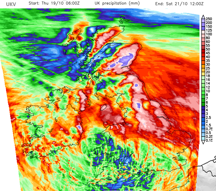
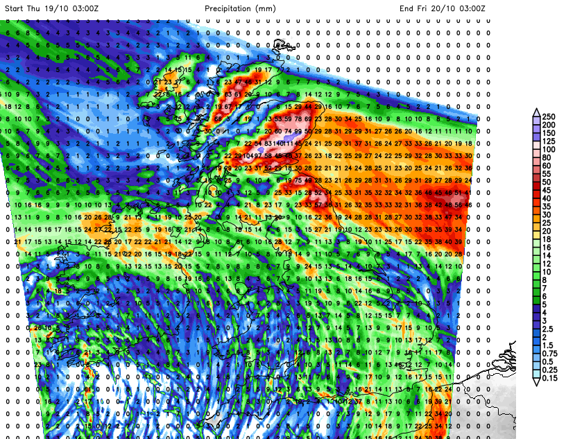
Forecast accumulation rainfall in 48 hours of Storm Babet. UKV
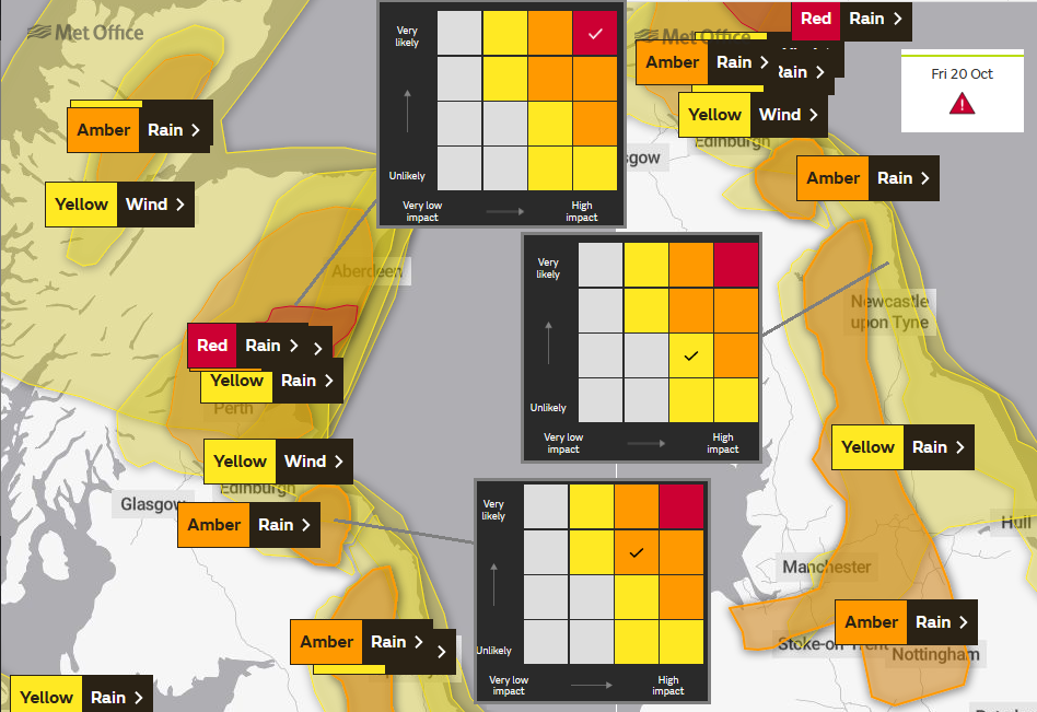
There are numerous rain and wind weather warnings from the UK Met Office, flood alerts from the Environment Agencies and flood warnings are being to appear. Exceptional amounts of rain are forecast for eastern/northeast Scotland with a rare red warning for rain later today, into Friday as a step up from the existing Amber warning. There is also an Amber warning for wind in this region and concerns about the stormy conditions along North Sea coasts.
"Exceptional rainfall is expected to cause severe flooding and disruption…exceptional rainfall falling across southeast Grampian, particularly the uplands of Angus and south Aberdeenshire. 100-150 mm of rain is expected to fall widely within 24 hours with some locations likely to see 200-250 mm of rain which is expected to cause considerable impacts both where it falls and lower lying areas further east." Met Office
Yellow, Amber and Red are all levels of warning about severe weather. What can happen is that when an amber is issued, that becomes the focus and people in the yellow-warned areas lessen their concerns. Again, when a red warning appears, those in an amber-warned area relax slightly. “Oh, it won’t be as bad as, say, eastern Aberdeenshire and Angus”. Don’t do that. There will be a lot of rain for northern England, SE Scotland, the Pennines, Peaks, Dales, eastern England, north Wales and eastern counties of Northern Ireland flowing in from the east during Thursday night and on Friday. The warning levels relate to impacts, not just rainfall totals. So, Scotland saw heavy and persistent rain with flooding two weekends ago. Babet’s rainfall will be incredible but it is also falling onto saturated ground, which will increase the impacts. Other areas will also see a lot of rain and locally that could cause disruption or flooding.
Think about the wind direction and where the rain shadow will be, this southeast to easterly flow is unusual for driving rain. Orographic uplift will mean that the windward side of high ground will get drenched and that water will then flow to lower ground. All of these factors are input into the Flood risk forecasts.
You will know the local areas that can’t cope with heavy rainfall, the low-lying route that never dries out properly and floods easily. People who live with the risk of flooding will know how to prepare but in a setup like this, SEPA (Scottish Environmental Protection Agency), the Environment Agency, and Natural Resources Wales want more people to sign up to their flood warning services and to read the preparation advice beforehand. That might be moving your car to high ground, charging mobiles and battery packs, thinking about where important documents are and just having a grab bag of important bits just in case you did have to leave your home or business property quickly. Similarly for the strong winds, securing bits outside the home and not just sticking your recycling out to be strewn around the community by Babet.
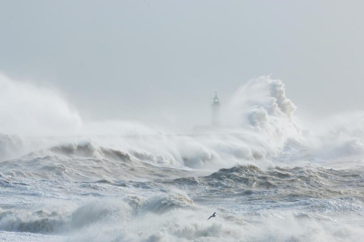
It has been a wet night for Northern Ireland, the Isle of Man, Wales, Yorkshire and more of northern England. The complex collection of low centres and weather fronts which will make up Storm Babet have been edging northwards overnight. The winds are strengthening and the inshore waters forecast for NE Britain mentions Easterly or southeasterly 7 to severe gale 9, increasing storm 10 at times with very rough to High Seas. It will be wild along exposed coasts. Also, inland further west there will be significant lee gusts with dangerous conditions in the Scottish mountains today
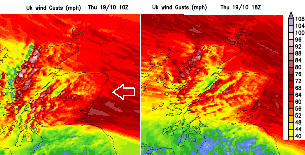
“A period of very strong easterly winds, perhaps gusting in excess of 70 mph at times… The combination of the very strong winds with prolonged heavy rainfall and the fact this is an unusual wind direction for winds of this strength will likely exacerbate the impacts. “Met Office
Overnight the strong easterly wind will spread down the coast of England, so by Friday morning it will be wind for eastern counties down to Norfolk and across northern England and the Irish Sea. The lee gusts continue and with E/NE gales for the Irish Sea by Friday evening which could impact ferry services here. The strong and gust easterly flow will continue for Scotland into Saturday morning.
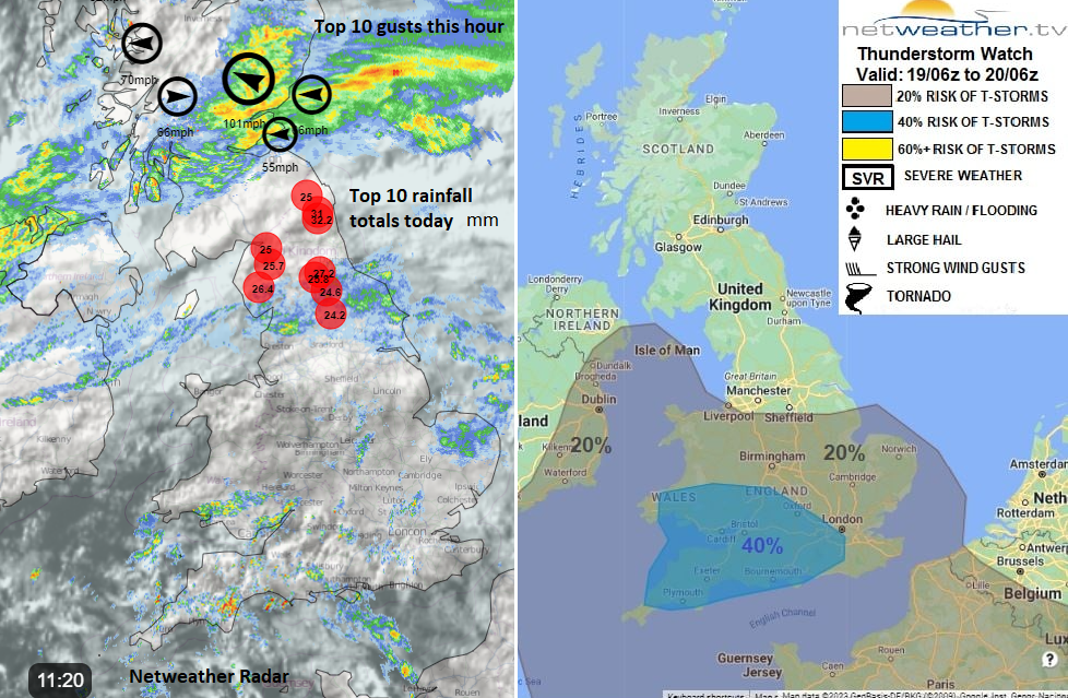
The main frontal band will continue for Northern Ireland, edging northwards from southern Scotland through the Central Belt and settling in for eastern Scotland. Another frontal band will follow from northern England into southern Scotland, particularly SE Scotland this afternoon into the evening. For England and Wales, there will be a rash of heavy showers which will also edge northwards today and could include thunderstorms, hail, sudden gusts and hefty downpours. As these merge with the rain over Scotland and Northern Ireland later today, there will be more heavy downpours appearing for SE Britain. These develop overnight spreading over more of England and then Wales by Friday morning. Some areas will escape this rain but others will become very wet. There will be some respite for Grampian on Friday morning as the worst of the rain and wind drives off the North Sea into the Forth, Scottish Borders, Lothian and eastern England

Keep an eye on the flood warnings, and the Met Office weather warnings which are usually reviewed at least daily late morning. It is worth looking beyond the colour level, there is more detail in the text and when you scroll down into Further Detail, information about the Matrix of Likelihood and Impacts, which is how the colour level is chosen.