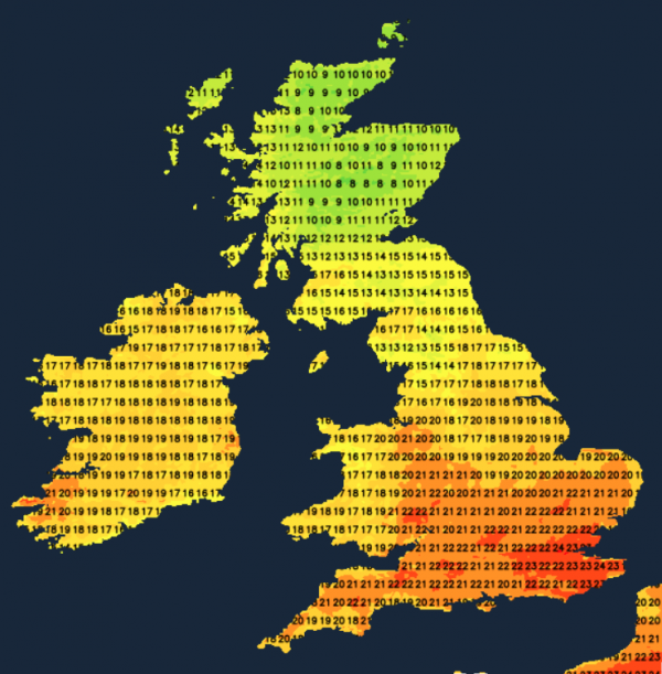
Heavy rain continues in parts of Northern Scotland today, adding to the flooding concerns. But, further south there'll be more bright or sunny skies along with unseasonably warm temperatures.
Heavy rain to the North of the Forth/Clyde valley continues to cause serious flooding problems, particularly around Aviemore, with an amber warning of heavy rain still in place across the northern half of Scotland. Further South across England and Wales, it remains utterly different on yet another fine unusually warm October day.
The current record-breaking, very high temperatures across much of Europe have been well 'aired', but what about closer to home? Parts of the South cleared 25C yesterday, and from the archives produced by T.O.R.R.O, we can compare the current unusually high temperatures with those of the past. On 8th October 1995, Hawarden Bridge (Flintshire) reached 25.6C, with a hot 26.1C recorded at Wisley in Surrey in 1921. The following day in 1921 saw a sizzling 27.8C attained at Kensington Palace, with 26.7C the maximum at East Dereham Norfolk in 1969. So it's happened before, with the sheer persistence of the current warmth the most outstanding feature.
The rain over Scotland should move a little further North today and become somewhat lighter, allowing The Borders and Northern Ireland to turn brighter and warmer. There should also be less in the way of high cloud that plagued the northern half of England and Wales yesterday. With the sunshine, albeit hazy in places, will come the warmth again after a grey, misty start with patchy fog here and there at first.
Across the South, temperatures reach a very warm 23 to 25C again, with 19 to 22C, a general maximum in mostly light winds. In complete contrast, in the rain across the northern half of Scotland, a much cooler 8 to 11C is more likely, except in Shetland. You'll see some sunshine here, but it'll feel chilly in a North Easterly breeze.

The rain over Scotland clears to scattered showers overnight, with perhaps a few showers moving into the far North of England by morning. The lowest temperatures about 4 or 5C in the far North but 7 to 10C across most of Scotland. Northern Ireland could also see a few showers after dark, while much of England and Wales stay dry. Clear spells and light winds allow mist, patchy fog and low cloud to reform in another mild night, especially in central and southern parts, with lowest temperatures 10 to 15C.
The new working week produces a further scattering of showers in the North. Further South, across most of England and Wales, it's again fine with spells of hazy sunshine once mist, patchy fog, and very low cloud have cleared. It becomes unusually warm in the sun again in mostly light winds, with top temperatures in central and southern parts between 22 and 24C. But in the North, while cooler, a more noticeable South Westerly breeze should lift temperatures to between about 11 to 14C.
After dark, Northern Ireland and the North and West of Scotland to see some rain, but it'll be turning milder here in a South Westerly wind. Further South, it remains dry and very mild while turning misty again, with patchy fog forming mainly in the South, where winds will be lighter. Lowest temperatures between about 9 and 14C.
Cooler conditions from the North mid-week replace the warm weather in the South. There'll be a few showers before fine weather returns but with lower temperatures and much chillier nights.
Loading recent activity...