


A detailed look at a brief plume of heat and humidity today followed by a thundery breakdown on Saturday, with warnings now issued for thunderstorms tomorrow.
After a relatively cool and changeable week, changes in the jet stream pattern are taking place since yesterday and continuing through the weekend will lead to very warm and humid air today spreading north today and into tomorrow, before a thundery breakdown on Saturday clears out the heat and humidity by later in the day.
Watch how the jet stream buckles at the end of this week, leading to warmer more humid air being pulled north

The jet stream, which has been zonal (west to east flowing) through the week across western Europe, bringing the cool and changeable weather, buckles to end the week – forming an amplifying upper trough over the North Atlantic just to the west of western Europe. This deepening trough will serve to back the flow from southwesterly to southerly, pulling in a warmer and more humid airmass from France today.
Hot today over parts of England, but a cooler and fresher feel on Sunday
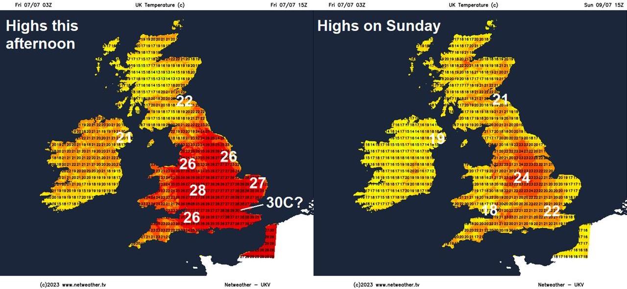
Temperatures look set to reach 26-29C, perhaps 30 across eastern England today. However, with the jet stream pattern continuing to evolve, the amplifying upper trough just the west looks to disrupt to form a cut-off upper and elongating surface low which extends east across the UK through the weekend – pushing a cold front east and bringing a thundery breakdown tomorrow of the very warm conditions. The upper low then looks to drift northeast to the north of Britain into next week, so will revert back to a less hot southwesterly early next week, before turning to an even cooler westerly direction from mid-week, as the jet stream turns more zonal. With it will be changeable conditions, with showers or longer spells of rain.
Low elongated north-south to the west of UK today, pulling warm and humid continental air north, then looks to elongate west-east over the weekend into early next week, bringing cooler and fresher air from the Atlantic, before the low drifts to the northeast of the UK through next week - keeping a cool and showery flow.

For today, it’s looking mostly dry and becoming very warm and hot -especially across central, southern and eastern areas of England – where temperatures will reach the high 20s degrees Celsius. Exception will be Scotland and N. Ireland – where it will be a cloudier start with some patchy outbreaks of rain, but even here it will turn drier and brighter from the south, though patchy rain may linger in NW Scotland while N. Ireland may see some thundery showers develop.
Tomorrow, after the promise of a fine sunny and warm start for some, cloud will increase from the south ahead of a cold front moving in from the west, with heavy showers and elevated thunderstorms perhaps already moving in across southern England by breakfast time - before developing during the morning across England and up to SW Scotland, as breeze convergence and falling pressure / heights create lift of warm and humid air. Often, in the UK in the summer, it’s not the cold front itself that leads to the thunderstorms, rather that it is prefrontal convergence and general falling heights aloft that lead to them. The cold front itself generally brings just a band of rain through. Though sometimes, if the change of temperature / moisture along the front is steep, then it may also bring thunder.
A few waves of heavy downpours and thunderstorms breaking out and moving northeast through Saturday, bringing a breakdown of the heat and humidity ahead of it.

There is some uncertainty over where storms will develop and how extensive they become as they become as they track northeast ahead of the surface cold front moving north and east and also the potential for more storms to develop following the cold front. ECMWF and UKV suggest storms developing from the south from central southern England up through the Midlands to northern England from 6am through the morning moving northeast. This first batch of heavy showers and storms clearing away across Scotland through the afternoon, before another band of storms perhaps develop along an occluded front following the cold front across West Midlands to NW England in the afternoon - pushing northeast across northern England and Scotland through the evening.

Met Office Thunderstorm Warning has been issued for parts of the UK:

Some of the thunderstorms may organise, given fairly strong deep layer shear, into clusters and become quite intense, bringing torrential rainfall leading to flash flooding, hail, strong winds and frequent cloud-to-ground lightning. Temperatures generally won’t be as high as today, but across the far east of England, ahead of the storms developing – we may see high 20s and perhaps 30C. Fresher conditions following the cold front clearing northeast, the cold front expected to lie between Glasgow and Isle of Wight at noon Saturday, then between Aberdeen and East Kent at midnight. Storms that form during the day will generally clear northeast from NE England, northern and eastern Scotland through late evening. Following will drier, quieter and fresher / more comfortable conditions to sleep in than tonight across all parts.
Then on Sunday, there is some uncertainty, with differences between models, over the risk of further heavy and thundery downpours breaking out. GFS / UKMO / ARPEGE / ICON bring an area of rain, perhaps thundery, northeast across SE England and East Anglia through the morning. The feature bringing this can be see on the fax chart below.

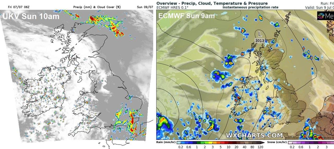
However, ECMWF doesn’t show this, rather it moves thundery rain northeast much further east over the near continent. So the jury is out on this outcome for now. Elsewhere, heavy showers and thunderstorms look to develop / spread northeast across SW England, Wales, Midlands, NW England, N. Ireland and perhaps into SW Scotland. Drier and sunnier further east across England and Scotland apart from early thundery rain that may affect SE England and East Anglia.
Next week looks to remain changeable, as low pressure close to the west drifts northeast across Ireland, Scotland then on to Norway later in the week. So a showery southwesterly flow first half of the week, turning showery westerly flow in the second half, perhaps some longer spells of rain thrown for some. On the cool side for July, but not hugely so. Perhaps a degree or two below average.


.jpg?w=350)


.jpg?w=175)