


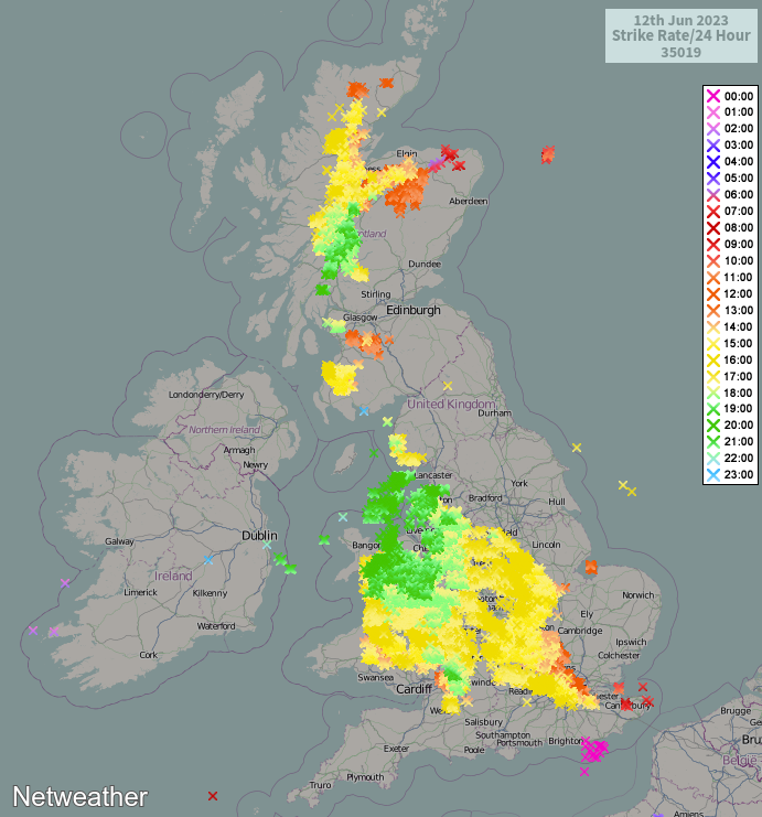
Today may not be just any June 13th; it could be the day that the June 13th Enigma finally falls and 30c is recorded. After 30,000 lightning strikes yesterday, the storm threat is also much reduced today and for the next few days.
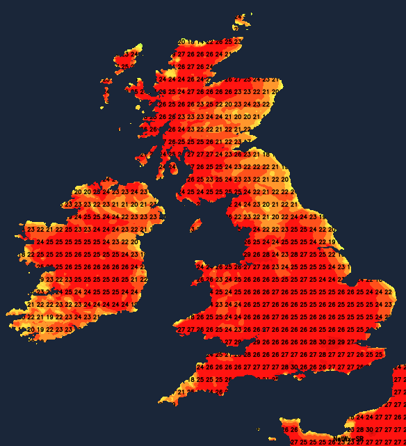
Update - 30c has been broken!
After 16 years of speculation on the Netweather community, today could finally be the day that the 13th of June enigma bites the dust. You're possibly wondering what the Enigma is; well, the 13th of June is the only day of meteorological summer to have never recorded 30c. The likeliest region for 30c to be breached today is central southern England, we'll just need to monitor the possibility of some convective cloud bubbling up in the heat of the day, and the outside risk of a thundery shower, which could scupper things - but the end of a meteorological statistical quirk is in sight.
Thunderstorm-wise, it's obviously been a lively few days, with yesterday seeing the peak of the action for now as over 35,000 lightning strikes were recorded. The timing couldn't have been worse in Manchester as it literally did rain (in bucket loads) on City's treble-winning parade, not that it seemed to matter to the thousands of fans who turned out - fair play to them!
Today, there is that slight chance of a few thundery showers in central and southern England, perhaps extending to south Wales. Aside from that, it's primarily across Ireland and western, particularly northwest Scotland, where there's an increased risk of downpours and thunderstorms. Elsewhere, there will be plenty of very warm, even hot sunshine, except on the cooler east coast where onshore breezes will again make their presence felt. Temperatures are expected to peak in the mid to high twenties widely.
As Jo covered in her blog yesterday, the heat and humidity will stick around all week, with the thunder and shower risk taking a back seat for the time being. Into midweek, there will be an outside risk of the odd downpour in western and northern parts, along with parts of Ireland, but sunshine will be centre stage. Accompanying that will be very high pollen levels, though, so if you are a hayfever sufferer, take all of the usual precautions.
As we move towards the end of the week and into the weekend, the chance of seeing a shower will increase in the west and north of the country in particular. Some models want to bring another thundery episode north later in the weekend, but there's some uncertainty over that, so it's just one to watch for now.
In the meantime though, keep an eye on the latest temperatures today as we wait to find out if the 13th June enigma is finally going to come to an end.


.jpg?w=350)


.jpg?w=175)