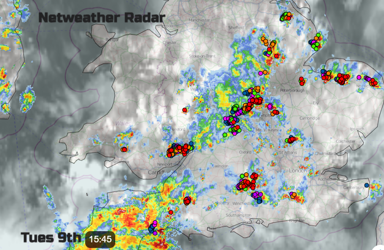
The UK has seen thunderstorms in the past few days with some hefty downpours. Unstable cooler air has nudged in from the northwest as sunshine heats the ground. Cold fronts continue to push their way over NW Europe and line up north/south through Europe.
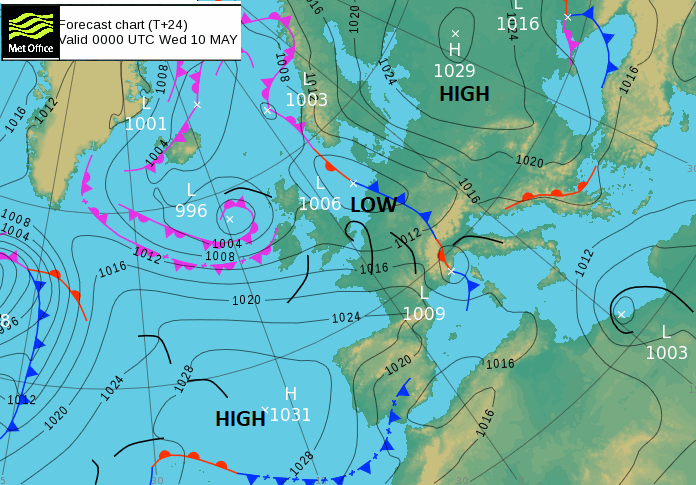
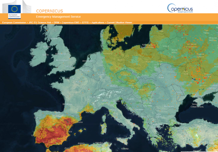
Early on Wednesday, there will be a high pressure off the coast of Spain, near enough to the Azores and another major high pressure over western Russia and the Baltic States. In between we have low centres, heavy showers, more cloud and rain and a red warning for northern Italy for heavy rain on Wednesday.
Eastern France and Switzerland already have rain warnings. The region around the Adriatic Sea, for more of Italy, the Balkans, up to southern Germany have warnings for heavy rain and gusty winds midweek as a low centre develops along the frontal boundary and stalls the heaviest rain.
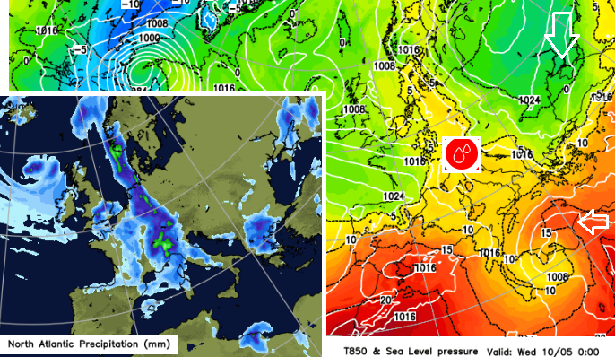
There is a temperature contrast across this frontal boundary as a low pressure rotating over the coast of Libya, near to Tunisia is giving a push of warmer air northwards over the Mediterranean.
This low will bring heavy rain and thunderstorms with strong gusty winds and blowing dust to north Africa with tricky coastal conditions and large waves. There are already strong wind, thunderstorm and sandstorm warnings for Tunisia .
For eastern Spain, there have been strong winds warnings and Menorca has a large wave warning by Wednesday in the brisk unstable NW flow.
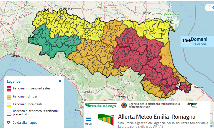
Italy has warnings about high rainfall accumulations, flooding and drainage difficulties with widespread and persistent rain on Wednesday. Landslides in the hilly areas are a danger. In the wider area, there will be heavy and thundery rain spreading over the Balkans from the Alps. Again, there will be the risk of flooding from the torrential downpours.
There are still concerns about the risk of wildfires across southern Iberia. Extreme, even Very Extreme Fire danger in areas such as Andalucía, the Algarve, Canary Islands and Madrid.
Myanmar and Thailand have seen higher than average temperatures around 38 to 41C which continue midweek. Provisionally, temperature records fell at what is usually the hottest part of the year. Laos 43.5C and Thailand 45.4C as the capital Bangkok rose to 41C. Conditions had been terrible with extreme air pollution in the heat and with forest fire smoke and crop stubble burning along with huge power use surges.
Thanh Hoa Province in north central Vietnam provisionally broke its previous record by reaching 44.1 Celsius. There had been scorching weather on Saturday, part of an ongoing heatwave which was extreme for May. The Vietnam Meteorological and Hydrological Administration attributed the heatwave to a hot low pressure in the west and strong Foehn effect winds. The risk of fire was extremely high during the heatwave, before the rainy season.
Vietnam and Laos saw huge thunderstorms. From the satellite imagery they have put the cloud tops at around 18km, 60,000 ft. Here in the UK on Tues 9th the cloud tops were around 9km, 29,000ft. These thunderstorms in SE Asia gave heavy rain but also lightning with some relief from the recent extreme heat.
The National Hurricane Centre has no tropical cyclones at this time. It is still a bit early, pre-season for the Atlantic and just for the eastern Pacific region.
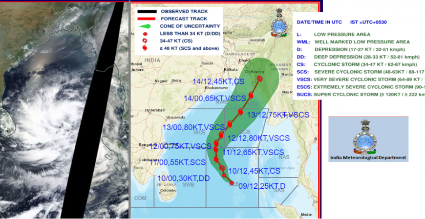
In the Bay of Bengal, it looks like a tropical cyclone should form soon. There is already an area of convective disturbance showing on the satellite imagery and conditions look favourable for a cyclone to form this week and could move north-eastwards towards Myanmar or Bangladesh. However, there is still plenty of uncertainty. Low-lying Bangladesh, at the top of the Bay, will be watching any developments carefully. Early warning systems have shown their worth, saving thousands of lives in recent years as severe cyclones in this region historically have forced deadly storm surges way inland.
Loading recent activity...