A collection of weather definitions, phrases and quantities for a bit of weather know-how.
Gale – winds of 34 to 40 knots, averaged over a period of ten minutes. (39-46mph). Beaufort Scale force 8
Severe Gale – winds of 41 to 47 knots (47- 54mph) recognised by slight structural damage (chimney pots and slates removed). Wave crests topple over, and spray affects visibility.
Storm – winds of 48 to 55 knots, seldom experienced inland (55-63mph). Beaufort Scale force 10
Knot – One nautical mile per hour (1.15mph)
Jet Stream - Strong winds high in the atmosphere, concentrated in a narrow band.
Jet Streak – a core of maximum winds within the Jetstream
Supercell - a long-lived and highly organized storm feeding off an updraft that is tilted and rotating. This can produce large hail, damaging winds and tornadoes. The American NWS define a severe thunderstorm as having “winds of 58mph or more or hail ¾” in diameter or larger.” Structural wind damage can be seen.
MCS Mesoscale Convective System – a large cluster of thunderstorms, seen as a squall line or multi cells. This collection of thunderstorms acts as one system and endures.
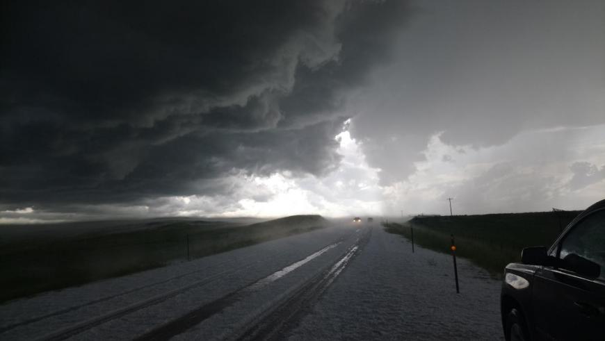
Straight line winds – Severe thunderstorms produce downdraughts where damaging winds rush down and out of the storm. Sometimes known as a gust front, this can result in severe weather conditions, sudden high winds and gusts which cause alarm and injury as they hit.
Funnel cloud- a whirlwind created by cumulonimbus clouds, a column of spinning air which is made visible as the humidity increases and the water droplets condensate out. If the vortice does not reach the land or the sea it is called a funnel cloud.
Water spout - A whirlwind that reaches to the sea or a lake. The circulation reaches a body of water.
Tornado – A violent rotating column of air that reaches the ground. It forms under a cumulonimbus, a thunderstorm and is visibility when humidity rises and the water vapour condensates out. “Although the flow of air is inward and upward, the cloud within the low-pressure funnel actually extends downward from the cloud base.” TORRO
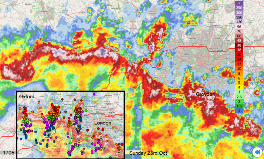
Squall line - a line of heavy showers or thunderstorms accompanied by strong, sudden gusty winds. A squall is a sailing term is for a sudden, localised increase in wind strength, with sudden gusts, darkening skies and showery rain. This strong localised convection can increase wind speeds significantly for a few minutes or over an hour.
Bow Echo – this is an accelerated section of a squall line, which bows out ahead and is distinctive on the radar display. A strong bow echo may indicate high winds in the middle of the line, where the storms are moving forward quickly and circulations can develop on either end. Brief tornadoes sometimes form on the leading edge which is created by strong downburst winds.
Turbulence - The announcement on aeroplanes which signals the need to tighten your seatbelt or return to your seats and hold onto your stuff. Smooth airflow won’t give any issues but when there is disrupted flow in the atmosphere with gusts and eddies, then you get a bumpy flight.
A cyclone- any area of low pressure. In the northern hemisphere, winds blow anti-clockwise around the low. A hurricane, a typhoon or just an extratropical Atlantic low pressure are all cyclones.
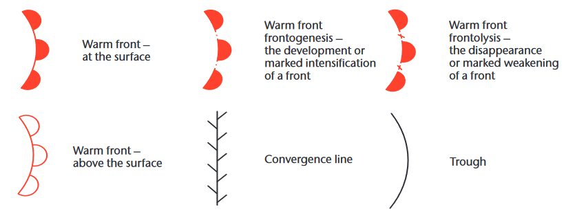
Trough- an elongate area of low pressure which enhances showers. A trough can be at the surface or aloft
Ridge- an elongated area of high pressure. These can subdue shower activity briefly, often before an incoming warm front.
Col – the area on a surface pressure map between two high pressures and two lows. Not a lot happens here weather-wise.
Anticyclonic Gloom- this is the endless grey in the skies under steady high pressure, which can be rather depressing. The anticyclone traps thick stratocumulus and this gives the dreary, featureless skies with little sunshine.
Precipitation and visibility
Visibility – the horizontal distance that an observer can see and identify a prominent object
Drizzle – this is very fine, fairly uniform and comes from stratiform clouds. Not from convective clouds. The fine drops are close together and do make a damp cloak but they are falling to the ground, not just suspended in the air like fog. Raindrops will disturb puddles, drizzle doesn’t really.
Relative humidity RH – the amount of water vapour in the air, compared to the amount the same air could hold if it was totally saturated.
Dew Point – the temperature below which water droplets can form in air. This varies with temperature and pressure
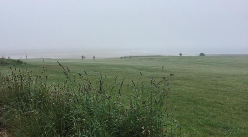
Fog – water droplets that are suspended in the air near the ground and cause Visibility to be reduced significantly. and it’s like being inside a cloud. The Met Office define fog as “a reduction in visibility to less than 1000 metres.” And dense fog “when the visibility falls below 50 m over a wide area.”
“Fog forms as a result of air near the surface becoming saturated and being cooled below its dew point” FRB. There are different types; radiation, advection (which includes sea fog), upslope and frontal.
Mist – this is a lesser version of fog, so less dense, and the visibility isn’t as poor. When the visibility is 1,000m or more and the relative humidity is between 95-100% there is mist. Very fine water droplets are suspended at ground level.
Haze - this is a reduction in visibility from solid particles. Visibility would be 1,000m or more but the relative humidity is less than 95%. Suspended particles could be dust, soil, salt and often air pollution particulates under high pressure over the UK with airflow from continental Europe, rather than the sea.
Freezing rain - consists of supercooled droplets which fall from the sky as rain, but when they hit a surface, it freezes instantly. This can be very dangerous but doesn’t occur too often in the UK.
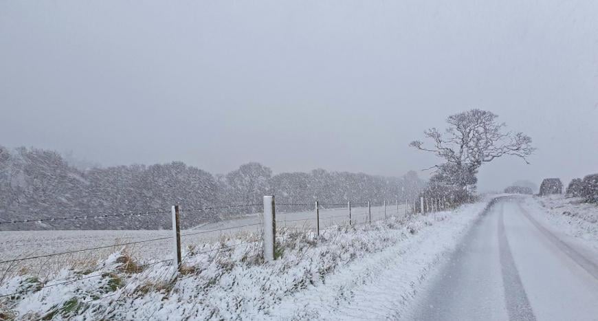
Blowing Snow – snow blown along by the wind which reduces surface visibility. Falling snow is recorded separately.
Drifting snow – when strong surface winds create an uneven distribution of lying snow but surface visibility is not affected.
Blizzard - a blizzard refers to a cold, strong wind that is laden with snow which significantly reduces visibility. UK Met Office “as moderate or heavy falling snow (either continuous or in the form of frequent showers) with winds speeds of 30 mph or more and a reasonably extensive snow cover reducing visibility to 200 metres or less.”.
In the US, where the word originated, a blizzard is a storm lasting around 3 hours or more with sustained winds of 35mph or more, frequent gusts to 35mph+ and considerable falling or blowing snow which reduces the visibility to less than 0.25 mile.
Freezing level - The part of the atmosphere where the air temperature is at 0 °C. sometimes you can be driving up a hill or mountain in winter and pass from rain to icy sleet then falling snow. You will have passed through the freezing level, or you might see the difference in the distance, white higher up on a hillside.
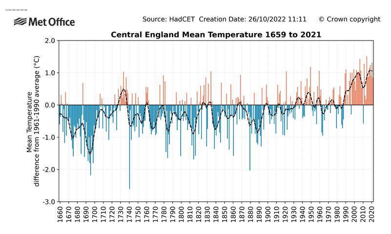
CET – Central England Temperature is a long-term average temperature for a selection of sites.
The CET dataset is the longest instrumental record of temperature in the world. The mean (from 1772 daily and 1659 monthly), minimum and maximum datasets are updated monthly (daily and monthly from 1878). “These daily and monthly temperatures are representative of a roughly triangular area of the United Kingdom enclosed by Lancashire, London and Bristol. Both series are now kept up to date by the Climate Data Monitoring section of the Hadley Centre, Met Office. Since 1974 the data have been adjusted to allow for urban warming: currently, a correction of -0.2 °C is applied to mean temperatures.” MO.
Diurnal range – the difference in temperature within one day, a 24-hour period from the minimum to maximum temperatures.
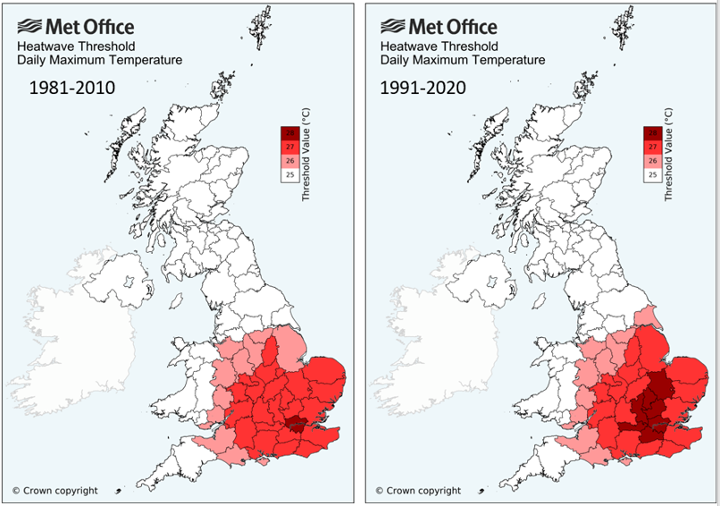
Heatwave - A UK Heatwave Threshold is met when a location records a period of at least 3 consecutive days with daily maximum temperatures meeting or exceeding a Heatwave Temperature Threshold" Met Office. These thresholds were recently updated.
Climate – the average weather and its variability over a period of time. The WMO World Meteorological Organisation standard is 30 years but it can range from months to millions of years.
Standard 30-year Normal Period – this standard ‘normal’ period is used for consistent calculations of climate averages. It should be long enough to reduce the impacts of very extreme events and so short-term climate variability. Examples are 1961-1990 and 1971-2000
Climate Change – A change of climate which is attributed directly or indirectly to human activity that alters the composition of the global atmosphere and which is in addition to natural climate variability observed over comparable time periods. WMO
Loading recent activity...