
Cat4 Hurricane Ian hit western Florida on Wednesday causing devastation and is now forecast to make another landfall along the Carolinas coastline.
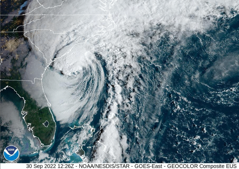
Looking at the footage and photos from the Fort Myers, Pine Island and Cape Coral region of western Florida the destructive power of Hurricane Ian is becoming horribly clear. Ian has not finished yet. After Smashing into Florida on the 28th it moved east and then back over the warm waters of the Gulf Stream. It has reached hurricane status once more, ready to hit South Carolina on Friday 30th.
“Hurricane Ian is expected to make landfall today in the Southeast. Life-threatening storm surge and rip currents, heavy rain and flash flooding, tornadoes, and hurricane-force winds can be expected along the South Carolina coast and into North Carolina” NHC Friday 30th Sept
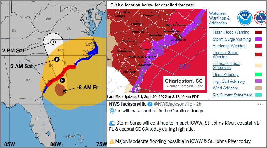
There are storm surge warnings all along the Carolinas coast with 4 to 7ft forecast for South Carolina. Heavy rain is forecast into the weekend with the flood risk for North & South Carolina and southern Virginia being highlighted currently. 3” to 8” of rain is forecast with up to 12” in places.
“On the forecast track, the centre of Ian will approach and reach the coast of South Carolina today, and then move farther inland across eastern South Carolina and central North Carolina tonight and Saturday.” NHC
Preparations are continuing with people in flood pflood-pronebegin advised to relocate. Charleston has been building a concrete sea wall to help protect the peninsula from Hurricane storm surge such as from Ian. However, it is not yet finished and so Charleston is vulnerable. Cars are being moved, hoardings going up and extra shopping is being bought.

It is expected to make landfall on Friday afternoon local time and then weaken rapidly. Already the radar and satellite imagery look rather ragged with Ian battling very strong shear but the next landfall today will bring further disruption and impacts. Ian will become an extratropical low during Friday night over North Carolina and then is forecast to fade later on Saturday.
Florida is still reeling from the Cat4 hit of Hurricane Ian. The search and rescue missions continue around cut-off coastal areas and with power and communications still cut off it is hard to find out information about people and property in the area.
Some NWS data - Charlotte County Punta Gorda airport 135mph and Grove City 110mph with Cape Coral recording 140mph at 1720 local time on 28th September (provisional data from NWS). 24-hour precipitation reports include Hardee County 12.24” Polk County 16.99” Lee County 14.42” (inland). Sarasota County 14.20” Pinellas County 10.78” (coastal).
Flood waters remain full of debris and broken power cables. There are strong rip currents along all coasts and floodwaters hide deep points, objects and harmful chemicals or sewage.

After dark, this is even more dangerous and there are warning to take care in power outages. Never to use generators inside or in garages to avoid carbon monoxide poisoning. Use flashlights, not candles, to avoid risk of fire. Even once the actual hurricane moves away the devastation will take a long time to sort out.
More Ian discussion in the Netweather community forum


.jpg?w=350)

