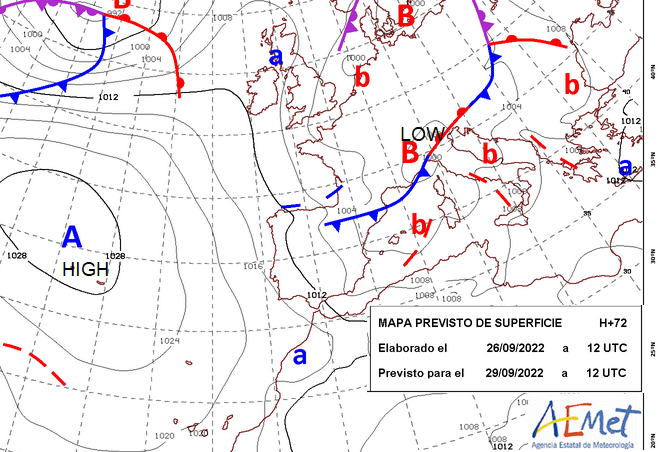
A slow-moving frontal system over Italy has brought torrential rain and thunderstorms to the central Mediterranean. There have been red and orange warnings for high winds and flooding. This heavy rain event has extended from eastern Spain (Murcia and Alicante seeing very high totals) to Sardinia, Italy, flooding in Sicily and to the Adriatic coast with torrents along the Croatian coast.
Alicante and Valencia region are prone to autumn heavy rains and flood events. This weekend was very wet. Many of these areas have seen an ongoing high fire risk, numerous wildfires burning and drought conditions. However, like here in the UK, sudden heavy and thundery rainfall will just run off the hard, dry land causing disruption and damage without perhaps the needed replenishing. For those on holiday for a few days this is the problem with autumn visits to southern Europe. Most of the time it is warm and sunny but there can be spells of very wet and windy weather when low pressures develop and stall.
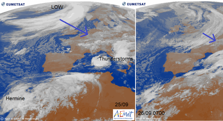
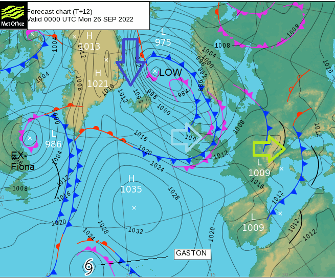
This frontal system continues to affect the central Mediterranean region, particularly central southern Italy but easing later this week. The cold front which cleared the UK on Monday will continue to push south into mainland Europe. Cooler for France and Germany with low pressure near to Denmark, southern Sweden and southern Norway. The same cold front will reach The Alps and also reach into eastern Europe to western Ukraine.
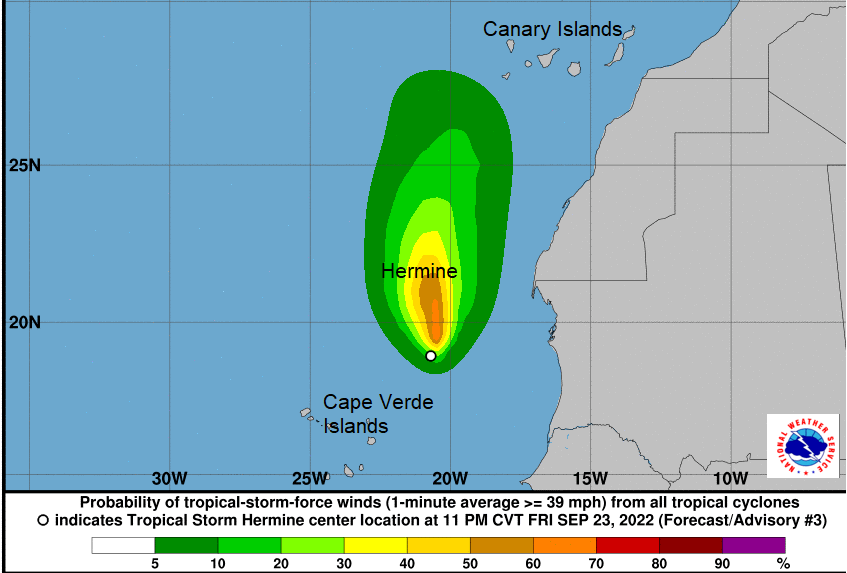
The Canary Islands have seen heavy rain and strong winds with flights cancelled or diverted this past weekend. Runoff caused flooding and landslips after Storm Hermine moved closer to the Atlantic islands. This short-lived Tropical Storm had been downgraded to a Tropical Depression as it drew closer but still managed to bring disruptive weather. The rainfall warnings continued for Monday and Tuesday but there will be some improvement. There will be more sunshine and temperatures up to 25C by midweek but there will be a fresh to strong north wind and a few showers at the weekend.
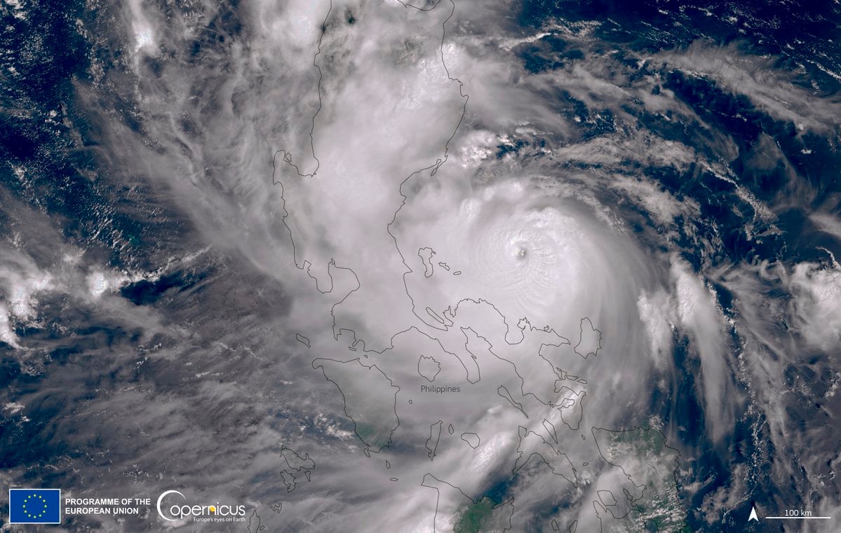
Hurricane Fiona made the weekend news as it hit eastern Canada and swept away people’s houses. Japan saw Tropical Storm Talas cause disruption from its torrential rainfall and Super Typhoon Noru (KardingPH) hit Luzon, Philippines.
Japan - Within the same week as Typhoon Nanmadol hit Kyushu, next up was Topical Storm Talas. Although this was not an intense cyclone it brought a huge amount of rain. This left thousands of people without running water or power in central Japan at the weekend after record rainfall. There was flooding and landslides with at least three people dead. Shizuoka Prefecture saw over 400mm of rain in 24 hours as Talas moved along the south coast of Honshu and over the central mountainous regions.
Philippines - It was the strongest storm for the Philippines this season and there were evacuations with five rescuers thought to have died in the floodwaters. One station measures 256mm of rain in 24 hours, (Subic Bay). STY Noru had explosively intensified to equivalent Cat5 status before approaching the north main island about 60 miles from Manila.932.7m
Noru is strengthening once more out over open waters of the West Philippine Sea/ South China Sea/East Vietnam Sea heading west towards Vietnam. The typhoon should make landfall by Wednesday with warnings and preparations beginning. This includes schools closing, boats seeking shelter or diverting and evacuations for those at risk of landslides or life-threatening flooding.
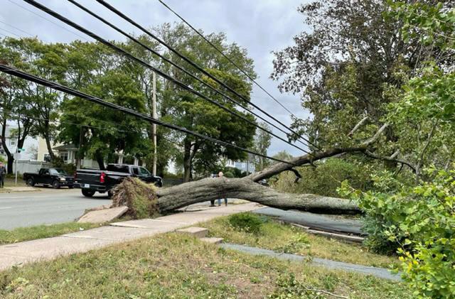
Canada - Hurricane Fiona made landfall as a post-tropical (equivalent Cat2) storm with the lowest pressure on record for Canadian land at 932.7mb. Fiona brought damaging winds, torrential rainfall, large waves and a destructive storm surge. The incredible footage of houses being swept out to sea will remain the most dramatic imagery of Fiona but for many Canadians, it was the number of trees and power lines down. The trees blocked roads and so access for power crews. Poles were broken, fallen trees damaged other things such as vehicles or homes and the weather was so vicious that conditions were unsafe for a good while. The CHC (Canadian Hurricane Centre) will be having a breather after such an incredible event.
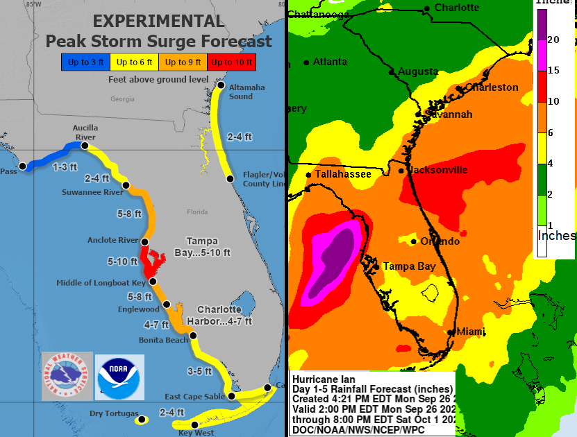
Early forecasts for effects of major Hurricane Ian on Florida
USA and Caribbean – Next up is Hurricane Ian, which has been rapidly strengthening on Monday. There are warnings for Western Cuba and Grand Cayman as it becomes a Major Hurricane with 3 to 10 inches of rain forecast and the risk of flooding and landslides along with the damaging winds. Then in the early hours of Thursday, it will approach the west coast of Florida, still as a major hurricane. Disney World will be keeping a close eye on this, with torrential rain forecast for mid week.
Thanks to Lindsey Saunders for Nova Scotia, Storm Fiona photos. Top satellite image European Union, Copernicus Sentinel-3 imagery.
Loading recent activity...