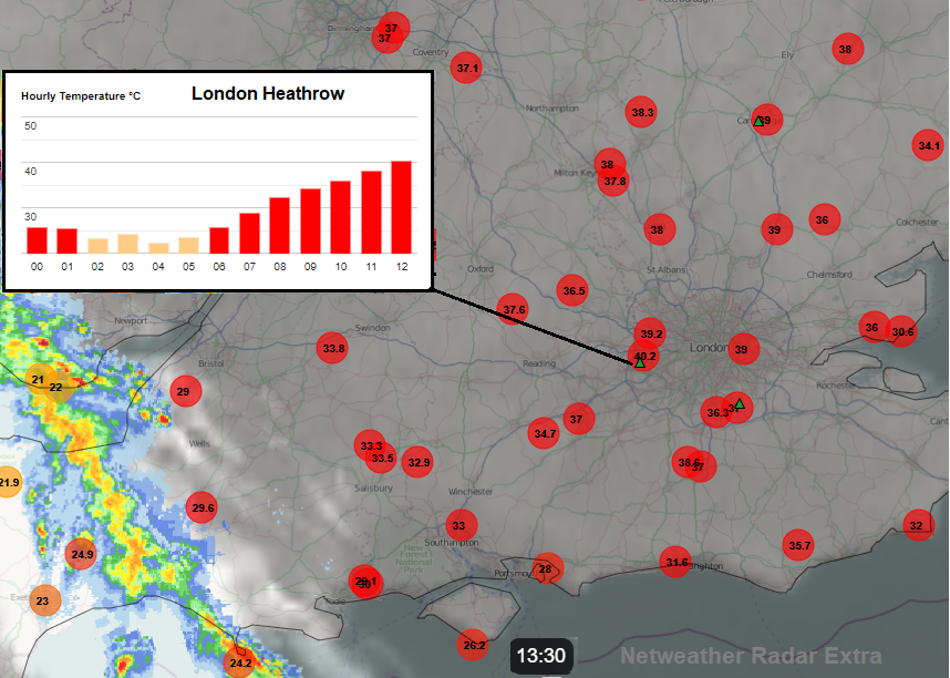
Today, Tuesday 19th July 2022 the UK saw its hottest day on record, passing 40 Celsius for the first time, leaving behind the 38.7C from 2019.
In an extraordinary heat event, Wales had its hottest day on record on Monday 18th with 37.1°C up from 35.2°C, Jersey saw its highest on record with 37.9°C (1.9°C above the previous record) and its warmest night on record dipping to only 25.5°C. Many local records fell during the two days. It was the warmest night on record in between with a provisional new UK highest daily minimum set at Kenley, Croydon of 25.8°C overnight. An astonishing value.

And the UK Met Office issued its first red Extreme Heat warning to accompany a wider Amber warning as infrastructure and people struggled. London Heathrow reached 40.2°C on Tuesday, early at 12:50 BST then Coningsby, Lincs at 40.3°C with other sites passing the 40C mark which is 104 Fahrenheit.
Scotland has also now seen its hottest day on record. 34.8°C at Charterhall in the Borders, exceeding the previous record of 32.9°C recorded in Greycrook, August 2003.
There have been so many comments and questions about the temperature readings during these two exceptionally hot days that a visit to the Weather Enclosure and Stevenson Screen seemed in order.
Official observation sites are carefully chosen and maintained. Some have recorded weather data for hundreds of years. Equipment within the Enclosure varies but the distinctive Stevenson Screen holds the thermometers. This white box has slats – louvres, to allow air to flow through over the shaded thermometers. This natural ventilation is important and the bottom of the box is 1.25m above the ground, for consistency.
The hinged door opens on the north side. This is important so that direct sunlight doesn't fall straight onto the thermometers and alter the reading. The observer has to be quick anyway because the air is being altered the whole time the door is open.
It can be obvious on a continual data feed when the door is opened as there will be a little blip in the trace.

On the observation maps, you will see those official sites that have an automatic feed and are updated on the hour, every hour. Some sites report four times a day, some daily and others weekly.
So, as we wait for temperature records to be broken there always has to be some care and holding back. Waiting for all the values to come in, some not til 09GMT next day or even the end of the week. Also for high ones to be validated and confirmed by the UK Met Office.
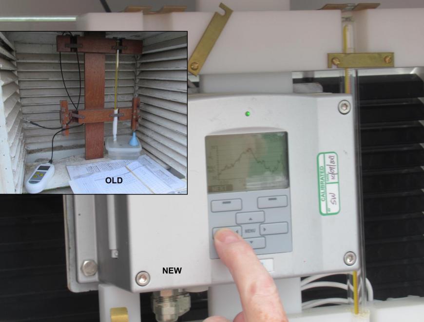
The screens used to be wooden, but are now plastic. White on the outside (reflecting heat), black on the inside (emitting). This one at Winterfield enclosure, East Lothian has recently been upgraded with the manual handling of a max thermometer being replaced and a Vaisala recording monitor centre stage. The volunteers now have to change the batteries every week.
The 09Z reading is taken quickly from the display and then the overnight minimum for 09z-09z from the horizontal liquid-in-glass thermometer. Also remembering to write down the value and reset the floating bar.
Next, the Wet Bulb temperature to work out Relative Humidity. Here the bulb of the thermometer is wrapped in a small piece of muslin and linked by a wick to a tub of water. That also needs keeping an eye on.
Thermometers- “A platinum resistance thermometer (PRT) is used for the measurement of air temperature at all synoptic stations and all supplementary stations that employ an automatic system. Two PRTs, one for operational use and one for backup, may be seen at the end of the looping black cables... The thermometer is calibrated every eight years providing traceability to the national temperature standard. “ Met Office

Next the maximum temperature value needs to be gleaned from the display. Those on an automatic feed will already have been looked at and recorded. This manual way needs a graph to be displayed and the top peak to be eyeballed, then the value recorded in the notebook. This is then input into the Met Office system each day. When I last visited the enclosure there was older equipment. The new display is taking some getting used to, with a magnifying glass needed.
Once everything is back in place, the hinged door is closed and secured. Other data might include, rainfall amounts, wind direction and speed, visibility, cloud cover and precipitation. Sunshine hours from the sunshine recorder, burnt onto special paper which is replaced each day.
Burnt away sunshine record, the number of hours of sunshine can be calculated from this special strip, wrapped within the Sunshine recorder each day
There might be other temperature values being recorded, grass temperature, soil at different depths but it is the Air temperature at 1.25 m above the ground that is important and most talked about.
If you have your own weather station or thermometer, positioning is key. Not in direct sunlight. You need airy shade even the wall or fence can pass on heat to the device. Stagnant air is no good and it's worth becoming familiar with other local sites, official and amateur to see how your readings compare. The WOW website has lots of sites including the 09Z ones and the Netweather Community forum has a daily thread for observations and a thread about weather stations.
These high temperatures have been quite something, worryingly so. But as my mum said about the local news weather presenters last night.
“I’m sorry, they may be very excited, but I don’t actually care if we break the record. I just want this heat to be over!"
Thundery rain from the west on Tuesday 19th and the end of this heat event by midweek, but it will be reflected upon and considered for a long time to come.
Loading recent activity...