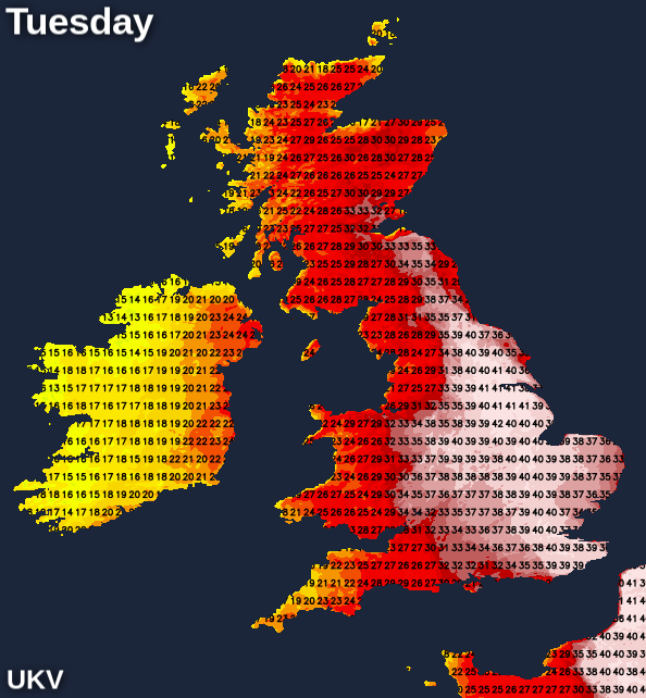
A dry, sunny and moderately hot day to start the weekend for most of the UK, but the main headline during this coming days is exceptional, possibly record-breaking, temperatures through Monday and especially Tuesday.
The UK record currently stands at 38.7C at Cambridge Botanical Gardens on 25 July 2019, but there is a significant chance of 40C being breached for the first time.

The Met Office has issued an amber extreme heat warning for England, Wales and Southern Scotland starting on Sunday. On Monday and Tuesday, the alert level increases to red for parts of England.
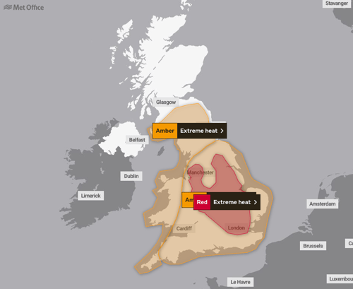
Scotland and Northern Ireland will start cloudy, but the rain will clear eastwards from Scotland during the morning, and it will generally brighten up except in the north of Scotland. For England and Wales, there will be some high cloud at times but generally plenty of sunshine, and it will remain dry. It will be a somewhat hotter day, but not yet exceptionally so. It will generally reach 22 to 24C in Scotland and Northern Ireland, and for central and southern parts of England, away from coasts, temperatures will generally reach 30 to 33C. West Wales, the West Country and the far north of England will generally be in the high 20s Celsius.
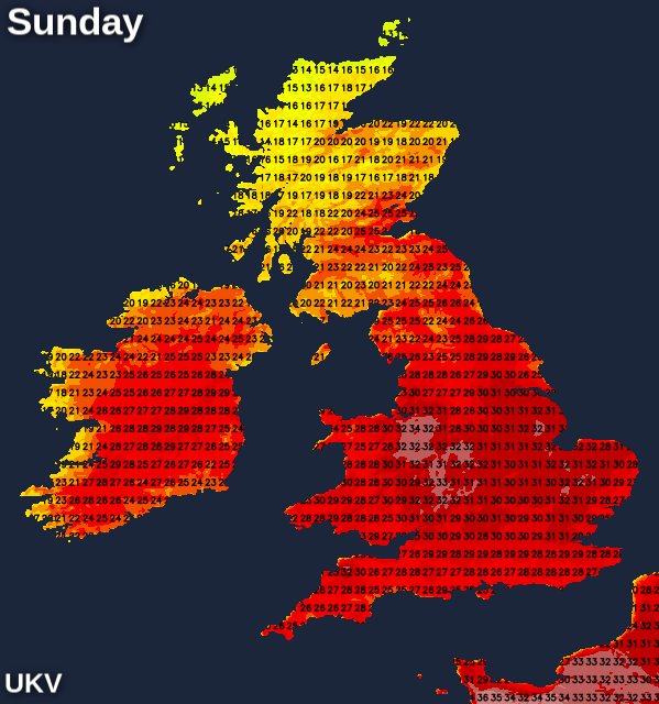
Sunday night will be unusually warm over England and Wales with widespread lows of 17 to 19C, and probably falling no lower than 20 to 22C in urban areas, particularly central London. Lows of 16 to 18C will be widespread over eastern Scotland and the Scottish Lowlands, again especially in urban areas.
Monday will start off cloudy in central and northern parts of Scotland, but this cloudier weather will become increasingly confined to the far north of Scotland during the day. Elsewhere, it will be sunny and dry, and exceptionally hot in places. Scotland and Northern Ireland will not be unusually hot, with top temperatures generally between 24 and 28C. However, over England and Wales, exceptionally high temperatures are forecast, with highs of 36 to 38C over East Anglia, the east Midlands and Cambridgeshire, and possibly 39 or 40C locally. West Wales and the West Country will generally see low 30s Celsius but some inland parts of Cornwall and north Devon may reach 35 to 37C.
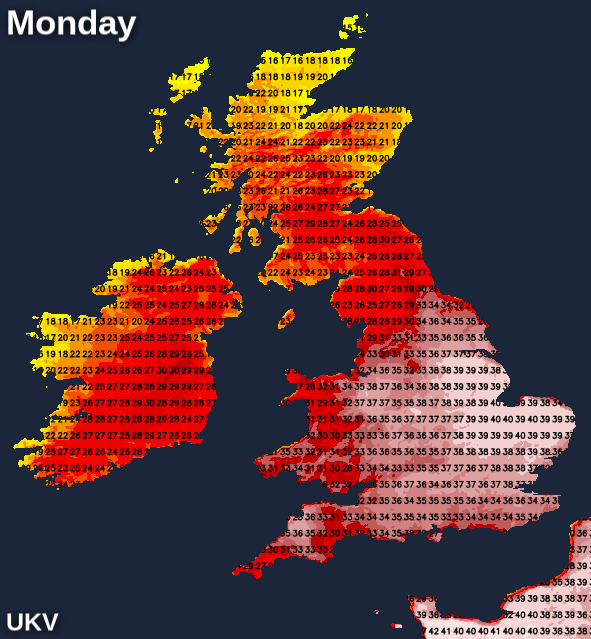
Sleeping may be difficult on Monday night for many of us, with minimum temperatures widely forecast to get no lower than 20 to 23C over much of England and Wales, with minima of around 25C in central London.
Eastern England will most likely see record-breaking temperatures on Tuesday. Temperatures of 37 to 40C are expected in a band extending from the south-east through Cambridgeshire and into the east Midlands. Even a 41 or 42C cannot be ruled out at this stage. Further north, record-breaking temperatures of 33 to 36C are expected in north-east England as far north as Northumberland. South-east Scotland will also be very hot, with temperatures reaching around 33C. Other parts of Scotland can expect 28 to 32C. However, it will turn much cooler in Northern Ireland and in west Wales and the West Country, with thundery showers spreading from the west.
Wednesday will see a breakdown of the heat, with potential for thunder, especially in the southern half of England, and it will be wet for a time over much of Scotland and northern England.

Kings Meaburn, nr. Appleby, Eden Valley, Nov 19th, 09.00 to 16.00 update: Grey all day, wth very few sunny moment. Dry. Current Temp: 5.6°C, Dewpoint: 1.1°C Today's High: 6.7°C @ 13:15 Today's Low: 5.6°C @ 15:45 Precipitation: 0mm Wind: 2.9mph...
9 minutes ago, Cheshire Freeze said: I think these days we need Strat reversals to a much lower latitude than we needed say 20 years ago. Is that a big ask though?
A thoroughly miserable day here, with rain - steady rather than heavy - until the last hour and grey 40+ for most of daylight hours with absolutely no sign of the sun. Yuk!
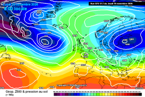
You can clearly see the problem Iberian heights. They’d have been hundreds of miles further S yesteryear- Here in 2026 it’s an omnipresent feature. It makes it more difficult for clean undercuts to occur and means that phasing of the Atlantic...
A cloudy wet afternoon with moderate rain at times Max temp 6.7C, now 5.7C, Barometer 989mb rising, Wind F2-F3 NE, Rainfall 7.8mm
Better from the GFS 12hrs run at T72hrs . Clean separation of shortwave energy compared to the ICON.