Plenty of fine, dry even sunny weather over the next few days for much of the UK. However, cloud and patchy rain continues to arrive from the far northwest. Temperatures rise into next week.
Overall, for the rest of this week, high pressure will be building in from the south-west and bring settled, often dry and bright weather to much of the UK. There will be warm sunshine and temperatures creeping up a few degrees but we are looking to next week for signs of heat. Signs, not certainty.
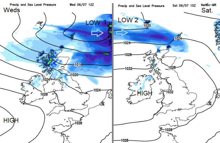
However, this high is not right over the UK and low pressures continue to pass to the north of Scotland with a cloudy, damp flow off the Atlantic for Northern Ireland and often NW Britain. Even reaching down through the Irish Sea into NW Wales too.
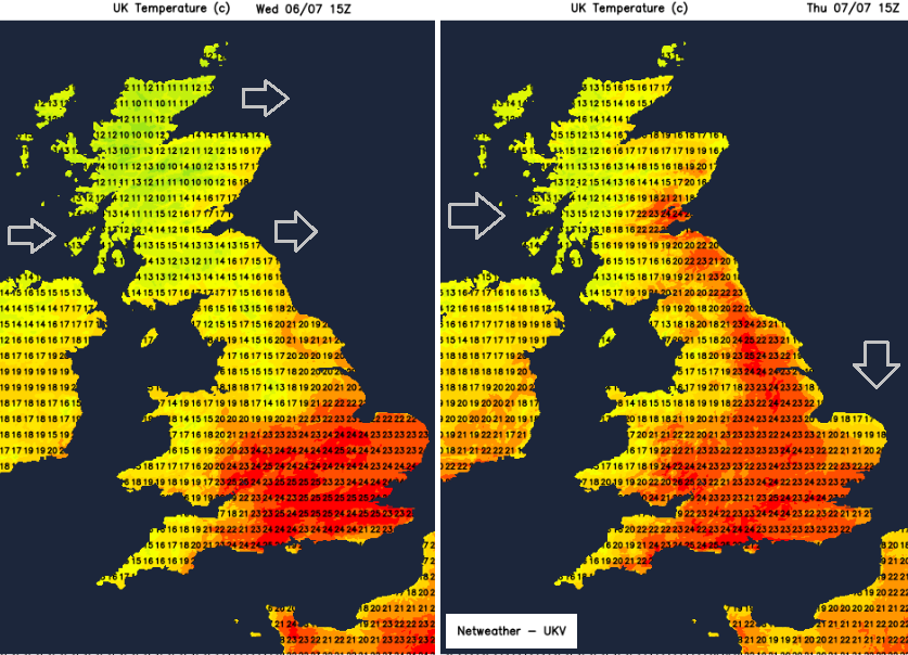
Wednesday will be a blustery day away from the southeast. Becoming windy through the afternoon and evening particularly for eastern Scotland, through the Central belt, NE England and over the Pennines. That’s as the first low pressure pulls away to Scandinavia and our winds veer to the northwest. This continues to push the cloudy, damp feed into western Britain and north coast of Northern Ireland but a shift by Thursday morning in a more northerly flow. County Down will finally see brighter skies, even a glimpse of sunshine. Across Britain, there will be sunny skies, much lighter winds and although the surface flow will be from the north, the temperatures will respond as we lose cool air away to the northeast and pull in warmer air with the high.
Through into the weekend, the UK settles into a mostly dry, bright or sunny picture with light winds from a mostly westerly direction. Today there is proper rain, from a warm front clearing NE Britain this morning and then frontal bands over NW Scotland. These bands then push cloud and patchy rain over more of northern and western Scotland, into Cumbria and Northern Ireland. Then the rain is confined to the Highlands for a few days, perhaps still grey and damp for Co. Tyrone and Co. Derry. The cold front reaches down through Britain overnight with temperatures into single figures for northern Scotland. Another warm front brushes by at the weekend, again dry and fine for most but rain in the far north.
This pattern continues into next week. High pressure bringing fine, dry weather with warm sunshine for much of the UK, especially southern Britain, but interruptions from the west over western Scotland, Northern Ireland and sometimes more of northern Britain. With increased cloud, blustery winds from the west and outbreaks of rain, coming and going. So still lengthy bright and dry spells, with strong July sunshine, just not as consistent.
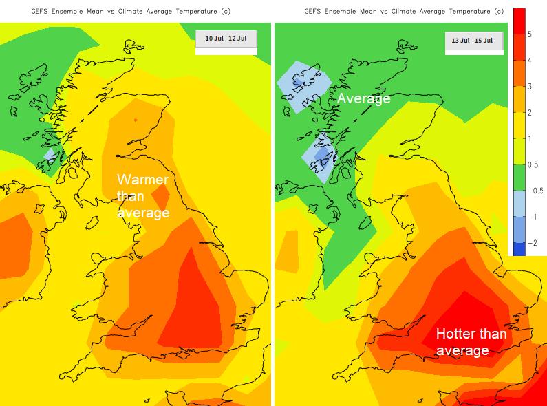
Tuesday 5th saw a top UK temperature of 23.8C at Kew Gardens in London. Cardiff 21.5C, Northern Ireland peaking at 19.3C and Scotland 20.2C. Today Greater London could see 27C and then northern Britain moving into the low twenties on Thursday. Gradually by the weekend, more areas move into the 20s C and then next week we see signs of low 30s Celsius. So, the warming trend looks strong into the start of next week but mid-week onwards there is low confidence. Will the high hang on? Will the heat building over Iberia this weekend push up through western Europe and reach southern Britain? Or just spread into central Europe whilst the cooler air from the northwest wins out for us? More discussion and chat in the Netweather community forum. Off on holiday abroad, a first look at travel destinations.