Today is the summer solstice and the next few days will be very summery for most. But, it is set to turn more unsettled and cooler at the end of the week.
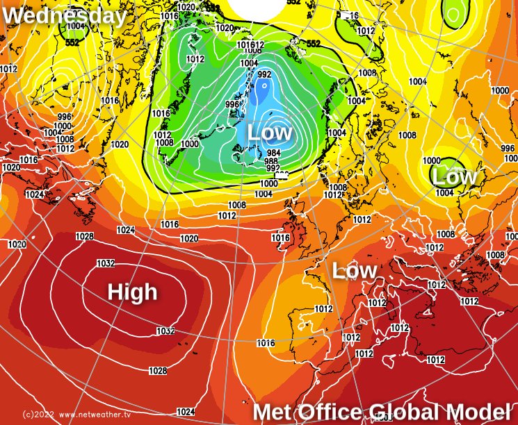
It's the summer solstice today when the midday sun is at its farthest North as it travels along the Tropic of Cancer, marking the beginning of astronomical summer in the northern hemisphere. We also see campers beginning to gather for Glastonbury, with the festival blessed by fine, very warm weather at least until Thursday. During Thursday, though, some potentially heavy showers could break out, ahead of it becoming more generally unsettled and showery by Friday and into the weekend when it'll be turning much cooler.
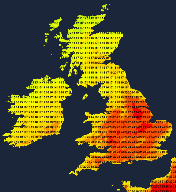
So while you'll need raincoats at times from Friday at Worthy Farm, in the meantime, most of us are in for a good deal of very warm, sunny weather. It'll be a mainly sunny day today in light winds for most of England and Wales. It'll become warm or very warm, with afternoon temperatures in the range of 21 to 25C. Across Scotland and Northern Ireland, you'll see more in the way of cloud and a few showers, with the cloud over the far North of England breaking up through the day. Here it'll be cooler in a Westerly breeze, with maximum temperatures 16 to 21C but only 12 to 14C in the far North.
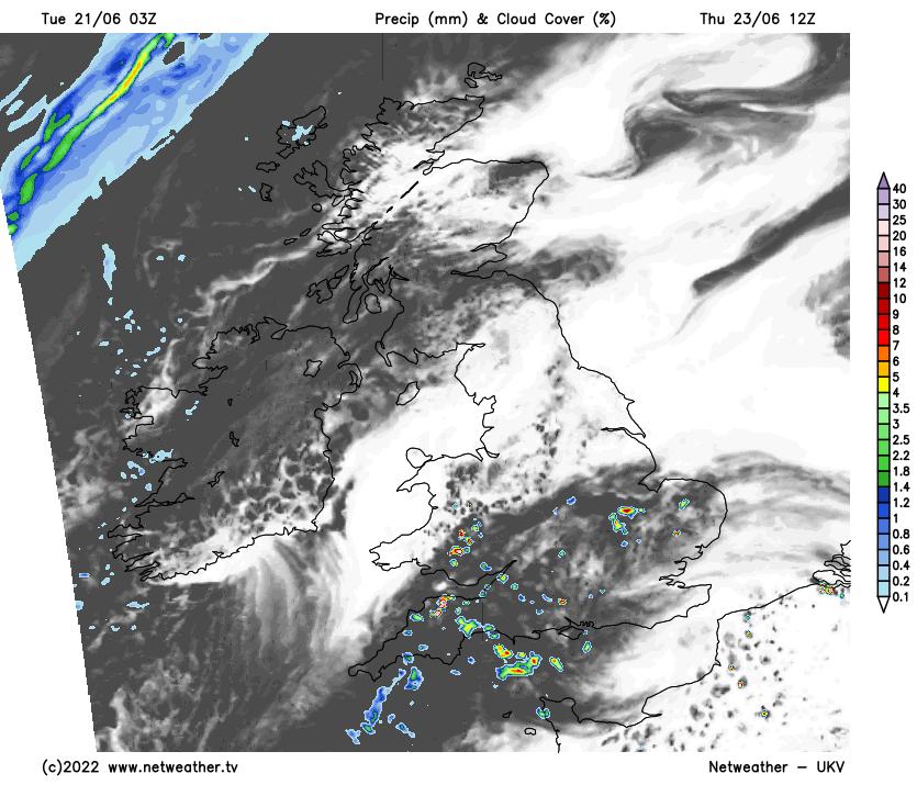
A Westerly breeze brings misty conditions and some light rain or drizzle during the evening and overnight to the North and West of both Scotland and Northern Ireland. Most places elsewhere have a summery evening followed by a dry, largely clear night in light winds. This'll allow a few mist or fog patches to form towards dawn in rural areas, but any will be short-lived. It's not expected to be a cold night, though, with the lowest temperatures across the country between 8 and 13C.
Under a slack pressure regime, Wednesday should be similar, with much of the country fine with long sunny periods in light winds.
The exception will be the North of Scotland, where a South Westerly breeze will bring cloud and some mostly light rain or drizzle, particularly to the Northern Isles, where together with some other West facing coasts, it'll remain misty. For most, though, it'll become very warm, even locally hot in the sunshine. Many places stay dry, although the heat could 'trigger' the odd shower later, but any will be few and far between. Temperatures reach 22 to 25C fairly generally and 26 to 28C in the best of the sunshine across central and southern parts, while the North of Scotland gets no higher than 13 to 15C.
Any showers that develop will soon fade, leaving most parts with another summery evening followed by a fine night with clear spells. Light winds allow a few short-lived mist or fog patches to form again towards dawn on a mild night when temperatures generally shouldn't fall below 9 to 14C. The exceptions will be the North and North West of Scotland and towards Donegal, where a South Westerly breeze continues to bring misty conditions and some patchy light rain or drizzle.
It remains mostly fine and summery into Thursday, but as it becomes humid over England and Wales, a few showers could break out, mainly in the South. These could be heavy giving thunder, ahead of the more generally unsettled and eventually much cooler conditions promised for Friday and the weekend.
Top Photo by Hello I'm Nik on Unsplash