Partially blocked situations are often a forecasting headachea0as fronts trying to move in from the West either slow down or become blocked, and we have a couple of those at the moment.
Partially blocked situations are often a forecasting headache as fronts trying to move in from the West either slow down or become blocked. We have a couple of them at the moment creeping slowly eastwards across the country before eventually grinding to halt and petering out into the coming weekend. So we can expect a good deal of grey, murky weather today, with rain in the West slowly spreading East.
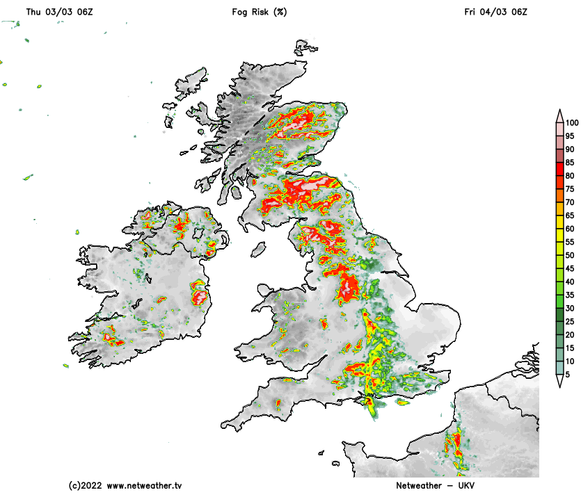
Ahead of the fronts, some eastern parts have begun quite bright even with a little sunshine, and it should stay this way over parts of East Anglia and the South East. Behind the systems, Northern Ireland will also brighten from the West with some sunshine, this spreading to West Wales and the South West later, but there'll be a few showers, mostly over Northern Ireland. Across much of Scotland through the remainder of Wales and in the West, it'll be dull and misty with outbreaks of rain or drizzle and some mostly hill fog, this working its way into central parts through the day.
Winds mostly between East and South will be lighter than of late, but it'll feel rather cold in the rain, where temperatures may get no higher than 6 or 7C. But a more general maximum will be 8 to 11C, with 12 or maybe 13C possible across East Anglia and the South East where you see some sunshine.
Much of Scotland, Northern Ireland and the far West of England and Wales see clearer skies moving in after dark. Light winds allow a few mist and fog patches to form by morning when it'll be cold enough for a touch of frost, as temperatures fall mostly to between -1 and +2C. The far East of East Anglia and places to the East of London may also see skies breaking, but elsewhere it remains misty, with further rain at times and some mostly hill fog, but here temperatures shouldn't fall below 5 to 7C.
Friday continues to see that same front bringing mist, mostly light rain, drizzle and some hill fog to much of central and eastern England, although Essex, Suffolk and Kent may stay brighter with a few sunny intervals. Further West, after a chilly start, there'll be some sunshine, and it'll be mainly dry, apart from a few showers mainly over Northern Ireland. Winds remain light, with top temperatures mostly between 8 and 11C.
Much of any light rain or drizzle should die back after dark, but with the front now almost stationary, many central parts remain cloudy and misty, with patches of hill fog. Towards East Anglia and the South East skies should be more broken, but with a chilly North East breeze developing. Over Scotland, Northern Ireland and in the West, clear skies and light winds lead to patchy fog and a frost again, with lowest temperatures -2 to +2C, but where you keep cloud 4 or 5C will be nearer the mark.
As an anticyclone becomes established across the country, it turns finer and drier over the weekend but with night frosts. It remains fine at first into next week, but, although becoming milder, it turns increasing unsettled from the West.