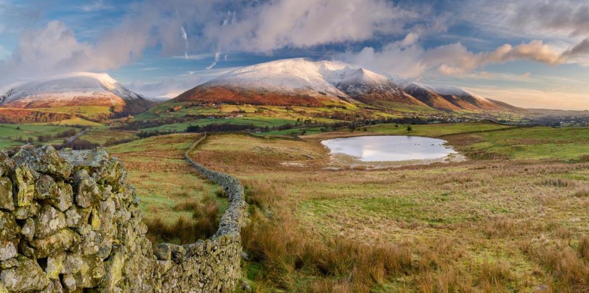
The winter so far hasn’t really panned out as forecast in the Netweather Winter Forecast issued back in late November, particularly for January and most likely for February too. For last month and this month it was forecast that there would be some episodes of high latitude blocking with periods of -NAO leading to cold weather and slightly below average temperatures for both months. January was above average temperature-wise for the whole of the UK, with a mean temperature of 4.7 °C, which is 0.8 °C above the 1991-2020 long-term average. Though there were north to south variations. January also turned out much drier than expected. February is expected to turn out average in the north to above average in the south temperature-wise, with rainfall around average in the north to slightly below in the south. The winter forecast called for slightly below average temperatures and below average rainfall, but also for anticyclonic conditions to predominate.
The Arctic Oscillation (AO) and North Atlantic Oscillation (NAO) indices have generally been positive so far this winter -which tends to indicate a lack of high latitude blocking. Though even when both dipped into negative in late December, it was still mild in the UK. Both indices look to remain positive through into late February, so remaining westerly with lack of blocking for sustained cold:


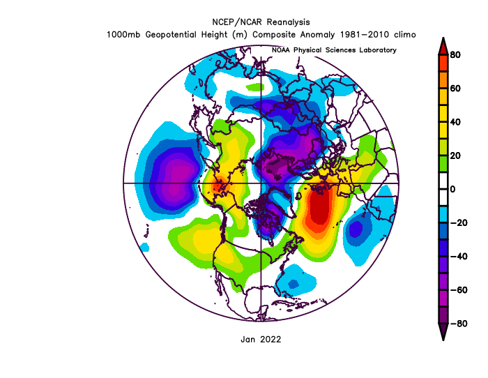
One of the main drivers that has overridden the other drivers, that were mentioned in the forecast to have an influence on the winter, has been the persistence this winter of a strong polar vortex in both the stratosphere (high up in the atmosphere) and for much of the winter so far in the troposphere (where our weather happens). Though the stratosphere and troposphere haven't really coupled strongly - they certainly seem to have been strong in tandem at times.
The strong polar vortex has generally prevented any high latitude blocking setting up on the European/North Atlantic side of the northern hemisphere that would have more likely led to sustained colder weather this winter. There has been blocking, but not at high enough latitude for long enough to bring sustained periods of cold and wintry weather for more than a day or two. A block did briefly appear over Greenland in late December, but it still didn't lead to any sustained cold wintry weather for the UK. Any prolonged blocking that has developed has been over the UK, particularly in January, and has favoured eastern and, more recently, southeastern Europe to receive cold and wintry weather rather than NW Europe. And this can all be related to the persistence of the strong tropospheric polar vortex with low 500 hPa heights to the north, northeast and northwest through much of the winter so far.
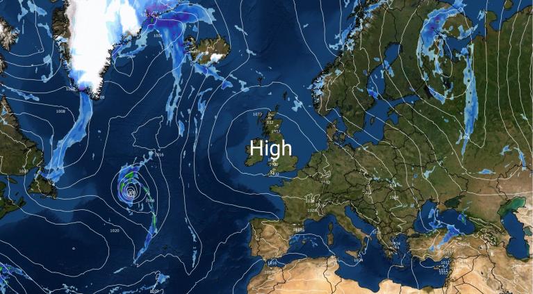
Mid-latitude high pressure blocking dominated NW Europe in January and led to mild weather in the north of the UK, average conditions with frosts in the south under the high. Any sustained cold and wintry weather over Eastern and Southeastern Europe:
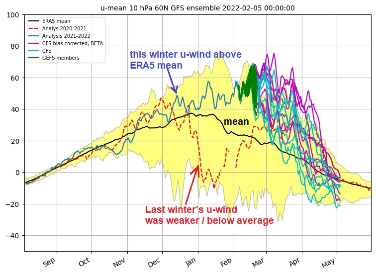
In the Netweather winter forecast I did factor in entering winter with a strong polar vortex (PV): “In fact the stratospheric polar vortex is stronger than average as we enter winter.” But, with a descending easterly Quasi Biennal Index (QBO) this winter, that often favours weakening of the vortex, I didn’t expect the PV to remain strong all winter. In fact, the last few days, the stratospheric polar vortex has broken date records for the strongest zonal mean zonal winds at 60N 10 hPa in the ERA5 dataset.
From weatheriscool.com:
####------------------------------------ Polar vortex status ------------------------------------###
The strat. vortex is currently stronger than all other years in the ERA interim record!!!
The zonal mean zonal wind at 10 hPa 60N is today (GFS analysis): 54.8 m/s
Weakest zonal wind at 10 hPa 60N in ERA interim record for todays date is: -14.6 m/s 2009
Strongest zonal wind at 10 hPa 60N in ERA interim record for todays date is: 53.3 m/s 1988
But there were also other influences in the winter forecast such as low solar input and forcing from weak La Nina become east-based through winter that pointed to greater chance of high latitude blocking and -NAO periods that would lead to cold and wintry patterns. But these influences seem to have been overridden by the polar vortex strength too.
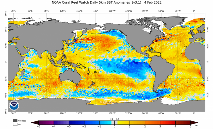
A lot of the winter forecast is based on analogues of previous winters where similar phases of pattern drivers were in place as this winter. However, global warming and climate change could mean these analogues are becoming less and less useful as a guide. The basin-wide warm North Atlantic SSTs this winter, perhaps driven by global warming, could be forcing the sub-tropical Azores-Bermuda high pressure belt and thus the polar front jet stream further north and northeast. This certainly seems apparent with the persistence of mid-latitude high pressure recently.
Could the warm Atlantic SST anomalies be forcing sub-tropical high pressure and the jet stream further north this winter? Especially been noticeable in January:
I will certainly will bear in mind for the future that a strong PV at the start of winter, a La Nina and perhaps basin-wide warm Atlantic SSTs are mostly probably going to lead a mild winter overall, despite other background drivers such as a eQBO and low solar that points to colder. Winter 2020-21, which although was La Nina as well, had a weak PV to start the winter. This led to some periods of sustained cold weather with snow for many at times in January and particularly early February 2021.
The UK’s weather this winter has been governed by alternating periods of the strong tropospheric polar vortex over northern Canada and Greenland in charge or stubborn mid-latitude high blocking high pressure in charge, the latter particularly persistent for much of January. Both polar vortex and blocking mid-latitude high features are interlinked though – with the low heights of the polar vortex driving a strong northward displaced jet stream which in turn forces a strong northward displaced sub-tropical high pressure cell to the south. Given the tropospheric polar vortex has been mostly over northern Canada and Greenland, these displaced strong high pressure cells have drifted north over NW Europe at times, when the jet stream has buckled north in response to upstream amplification over North America, where cold air of the polar vortex has plunged south at times from Canada into the USA.
Early December up until around the 14th saw a strong tropospheric polar vortex to the NW and low pressure near the UK, with a positive Arctic Oscillation (AO) and North Atlantic Oscillation (NAO) regime that brought unsettled conditions, chilly for the first 10 days before trending milder thereafter. High pressure then built in mid-month, but it remained mild. The high then drifted north towards Greenland to form a block, temporarily, leading to a brief period of negative AO and NAO. But this only brought cold air to northern areas for a few days, before low pressure low pressure eventually moved into the southwest bringing more unsettled but mild conditions between Christmas and New Year. With low pressure to the west and a long draw southwesterly flow from beyond the Azores, it turned exceptionally mild on New Year’s Eve and Day.
Into early January the tropospheric polar vortex had reconsolidated over the arctic to the north and northwest after a brief hiatus in late December. So the first ten days of January were low pressure dominated and unsettled. Then from around the 11th, high pressure built in from the Azores and remained in charge of UK weather for the rest of the month, but with a positive AO and NAO index throughout January. It remained milder than average in the north with the flow off the Atlantic. But across the south, light winds and clear nights led to more frosty nights – so temperatures were closer to average than further north.
So, what are the prospects looking like for the rest of this month and winter? Well, the polar vortex looks like remaining as strong as ever, as already mentioned, in the stratosphere the vortex is breaking records with wind speeds at 10 hPa / 60N at the moment and may continue too over next few weeks. Generally the PV tends to weaken as we head through February and into spring, but no signs of that occurring for now. But in terms of the weather over the next few weeks, it looks like the tropospheric polar vortex will expand further south over the North Atlantic than was the case in January, so this means the jet stream will be further south.
Tropospheric polar vortex dominating the far N Atlantic and NW Europe weather as head towards mid month and likely beyond. An unsettled westerly flow, but with the jet stream further south than last month, some cold polar incursions possible:
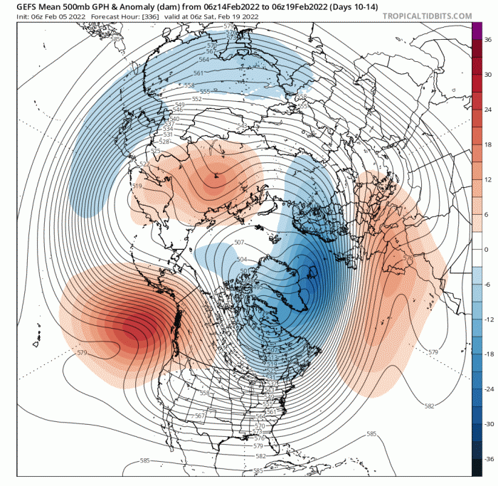
This translates to more mobile, cyclonic and unsettled conditions for the UK over next few weeks, with winds predominantly from a westerly quadrant. Sometimes southwesterly or westerly, brining in mild air, but also veering northwesterly at times, bringing in colder polar air – as the jet streams dips south at times. Such a pattern favours episodic spells of a few days of cold weather with snow, especially over hills in the north. The odd day or two of transitory high pressure can’t be ruled out following these colder incursions, which may bring dry weather with overnight frost. But for the south, nights with frost look less than in January. There could also be a few storms bringing strong winds to parts of the UK too, as one or two lows deepen in the vicinity of a strong jet stream near or over the UK. So we could see another named storm following Corrie.
Loading recent activity...