A blocking area of high pressure will be with us through into early next week, but it looks to turn increasingly unsettled as we head into the Christmas Weekend. With cold air not far away though, we could see some snow, but low confidence for now.
After an unsettled, sometimes cold and stormy period of weather earlier this month, culminating in Storm Barra on Tuesday last week, the weather has gradually settled down this week from the south. It is likely to remain settled through to the middle of next week, as a blocking area of high pressure builds across the UK to end this week. But changes are afoot from the middle of next week and through the Christmas Weekend, with more unsettled conditions taking over, but with colder air in the mix, there could be some snow for some on the Big Day.
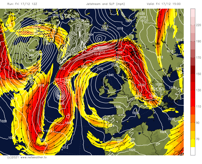
Jet stream buckling to end this week, allowing high pressure to build across the UK, which will hang around into early next week
What’s causing this change from the first half of the month to a more blocked and settled pattern over the next few days is likely being driven by changes in teleconnections driven by atmospheric forcing far away over the tropical Pacific.
Despite a strong stratospheric polar vortex as we entered winter, which is forecast to remain strong this month, the troposphere (where our weather happens) hasn’t really coupled with the stratosphere high up in the atmosphere.
The tropospheric polar vortex did show signs of becoming strong and perhaps coupling with the stratosphere, which was responsible for the recently flat and zonal upper flow or jet stream across the Atlantic. However, the jet stream is suddenly buckling over the Atlantic to end this week. One of the main triggers for this buckling, or more amplified upper pattern, is the movement of the Madden Julian Oscillation (MJO) wave over the western tropical Pacific.
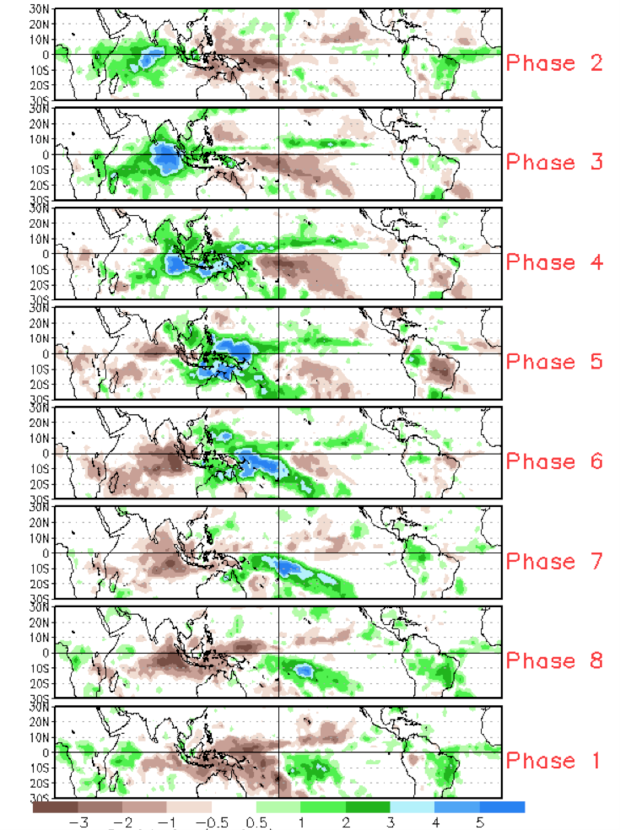
The MJO is a large-scale coupling between atmospheric circulation and tropical convection over the tropics, but has far-reaching impacts on northern hemisphere extratropical weather through Rossby Wave propagation. The Rossby Wave propagation depends on the longitude of where the enhanced convection associated with the MJO wave takes place. As the MJO has a significant impact on northern hemisphere weather patterns, including North America, the Atlantic and Europe, there are correlations that can be made between the 8 different phases of the MJO and the lagged impacts on the upper air patterns that might be expected over the North Atlantic and Europe based on composites of previous events.
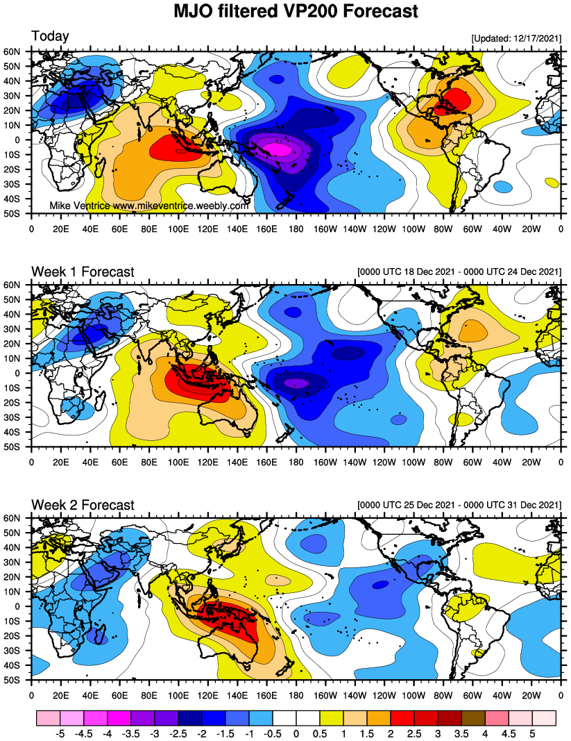
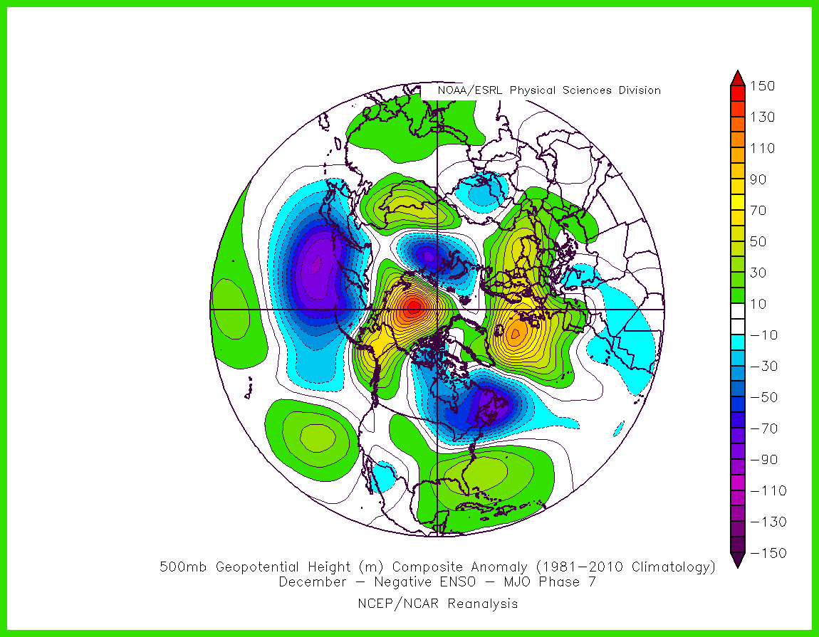
Current VP200 forecast for the MJO shows enhanced convection (blues/purple) over the western Pacific near the Solomon Islands today (phase 7). This area of convection only slowly moving east to the north of Fuji over the next 2 weeks.
Positon of the 8 phases of the MJO wave over the tropics is where there is enhanced convection in blue:
The MJO has now moved into phase 7 and is likely to stall here for the rest of the month. Phase 7 often correlates to an increase in blocking high pressure over northern Europe and the NE Atlantic, including the UK, after a lag of around 10 days, as the composite of phase 7 in December during La Nina suggest vs the pattern developing next few days.
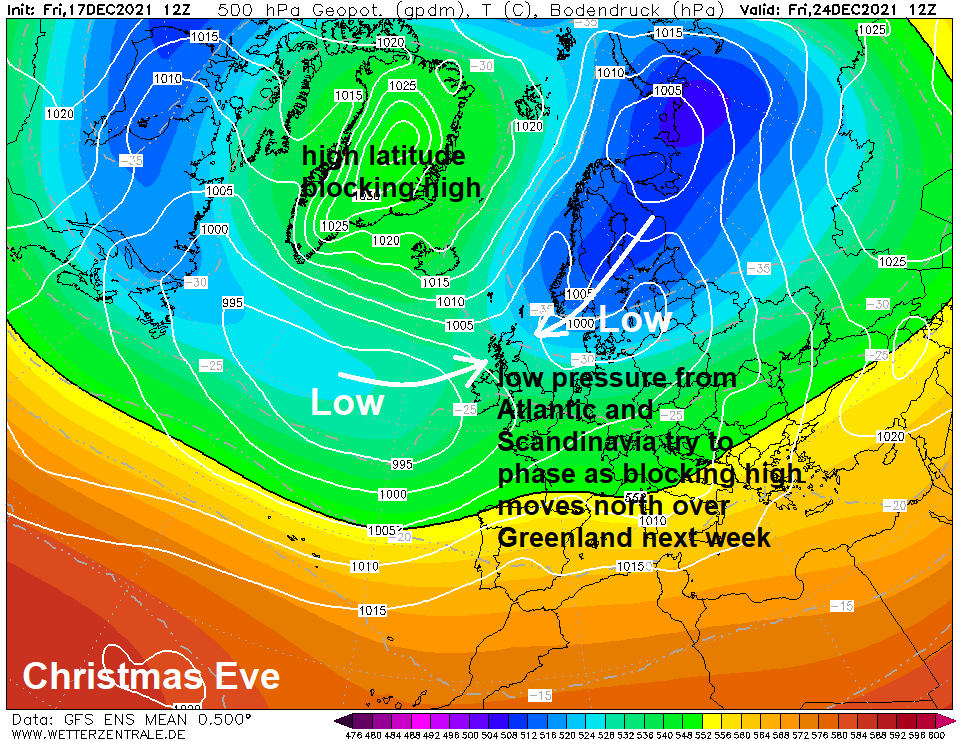
The large anticyclone looks to sit centred near or over the UK through into the start of next week, before the high drifts north towards Iceland and Greenland from mid-week. This then looks to allow upper troughing / surface low pressure over the Atlantic to move in from the west but also allowing upper troughing over Scandinavia to extend west and southwest. These two areas of upper troughing phasing together to create a continuous belt of troughing / lower pressure from the Atlantic through into northern Europe with high latitude blocking to the north. This means unsettled conditions for NW Europe from the middle of next week and through the Christmas weekend, but also turning colder.
Where these two areas of troughing phase is uncertain for now – but will make all the difference to where will be on the cold northern side of the belt lows moving west to east and where will be on the milder southern side. The colder northern side will be in an easterly or northeasterly flow, which will be dragging in air from a very cold Scandinavia – so anything that falls from the sky will likely be snow. Rain is more likely on the southern side of these lows. How far south or north the strong westerly jet stream tracks into Europe will determine this boundary between cold and mild across the UK over the Christmas period. A difference of a few 100 miles will determine who might see a white Christmas and who sees a green Christmas.
.png)
For now, the models generally agree so far today on northern Britain perhaps being cold enough for snow to fall, with rain more likely in the south.
But, there’s a lot of uncertainty. Christmas Day is too far out for the models to get an accurate handle on what the weather will do where in the UK. Especially when high latitude blocking is involved. The models are unlikely to have a confident handle this far out on the shape and position of the block around Greenland and Iceland later next week and thus the angle and latitude of approach of the Atlantic upper trough and surface lows pushing in from the west next week and where troughing from the Atlantic and Scandinavia phase over NW Europe.
We probably won’t get a more concrete idea on how far south cold enough air for snow to fall will get until early next week at the earliest. So, despite the stories in the media suggesting a White Christmas, it’s by no means certain. But it does look like being cold for many at least.