Light winds for bonfires and firework displays tonight. The weekend looks windier as low pressure passes the far north of the UK and brings gales, large waves and flooding concerns.
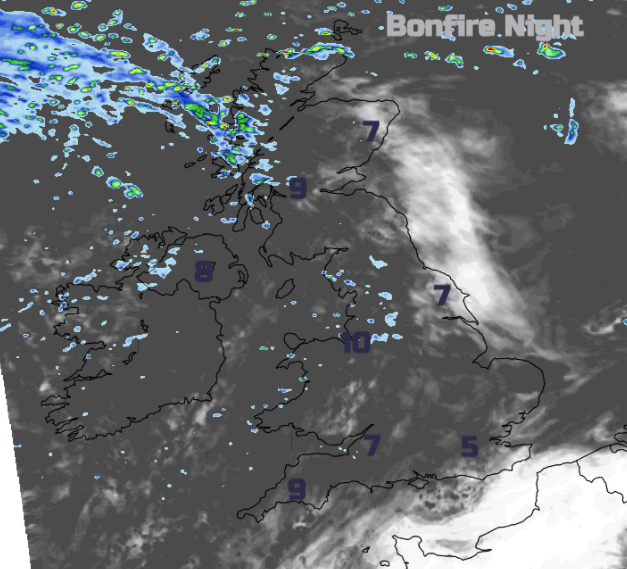
Remember, Remember the fifth of November. The weather is looking quiet, although not quite crisp and frosty for most with winds will be light. Under clear spells for eastern Britain, it will feel nippy this evening but not as cold as this morning. More cloud, even a little patchy rain, further west. Most places will be dry for Bonfire Night. Low pressure at the weekend will bring wet and windy weather over northern areas on Saturday and then possibly stormy conditions for the far north of Scotland during Saturday night into Sunday.
"Inshore Waters from UK Met Office OUTLOOK Wind -South or southwest 4 to 6, veering west 6 to gale 8, increasing gale 8 or severe gale 9 later, perhaps storm 10 later. Sea state …becoming rough or very rough in north, then high or very high later in north. Cape Wrath to Rattray Head including Orkney"
The UK has been in a colder northerly flow for a few days resulting in a frost for areas that have seen clear skies. Oxfordshire fell to -5C this morning, Hampshire and Dorset -3C with parts of inland England starting the day around or just below zero. For Saturday morning there will be more high cloud from the incoming low, so it will be parts of southeast England that might still see temperatures dip down to 3C if there are clear slots. Sunday morning will have more of a westerly breeze for southern Britain, so no frost or fog and it will be windy further north.
By day Friday will be fair with light winds. The temperatures recover slowly in the south with sunny skies. Northwest Britain and Northern Ireland will see a few light showers with more cloud. It starts with brightness here, but the cloud will thicken, and the showers turn heavier by this afternoon for the NW Highlands. Little changes by this evening, just a bit more of a westerly breeze for the northern half of the UK, still light. Not as cold as it has been.

Friday’s steady weather is thanks to high pressure out in the Atlantic. This does still manage to keep a lot of fair, dry weather for southern Britain through the weekend. However, the deepening low pressure which moves south of Iceland, near Shetland then to southern Sweden is like a rude autumn interruption whirling by.
The Met Office has issued a wind warning for northern Scotland for Saturday evening and Sunday. Shetland will be closer to the centre of the low pressure so misses the worst of the winds but could see a large westerly swell picking up by Sunday. Gales even severe gales are forecast with gusts over 75mph through Saturday night and into Sunday. The weather warning mentions coastal conditions. This low coincides with high spring tides and on Sunday as the low moves over the North Sea there are concerns for eastern Britain.
“It could generate a small tidal surge on top of what is already a high spring tide. Lots of uncertainty at this stage, but we’ll be preparing for a Thames Barrier closure.” Env. Agency
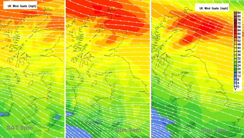
So, this part of the forecast carries concerns of flooding, wild weather for northern mainland Scotland, the Western Isles Saturday night and Orkney into Sunday but then extending over Grampian in particular by Sunday.
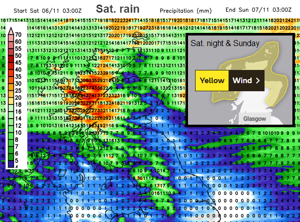
And yet there is a wider picture of windy weather this weekend. Many places do stay dry but there will be rain for Snowdonia, Cumbrian and particularly over western/NW Scotland.
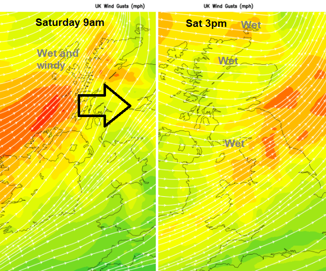
By Saturday morning the cold front from the low pressure near Iceland will be over the Western Isles and then bring a spell of heavy rain and strong, gusty winds right across Scotland. It will be slow-moving through Saturday morning, soaking Glasgow for COP26, reaching Northern Ireland and then Cumbria. The heavy rain and gusts reach northern England and north Wales in the afternoon with brighter skies appearing post front for western Scotland. But in that cooler, clearer air there will be the strong westerly winds with the wildest weather still to come for the far north.
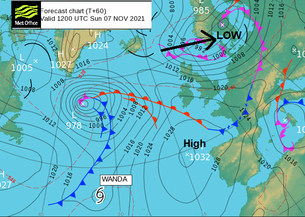
The high pressure does hold on for the south into the new week but by then another low pressure will have spun up across the northern Atlantic and this one links back south to Wanda. Wandering Wanda is a bit like a lost sheep. Really quite late in the tropical season but still managing to find some slightly warmer waters, less shear and perk up a little. As the front from next week’s Atlantic low engages Wanda “will become embedded within the frontal zone, and thus have made the transition to an extratropical cyclone. “ NHC
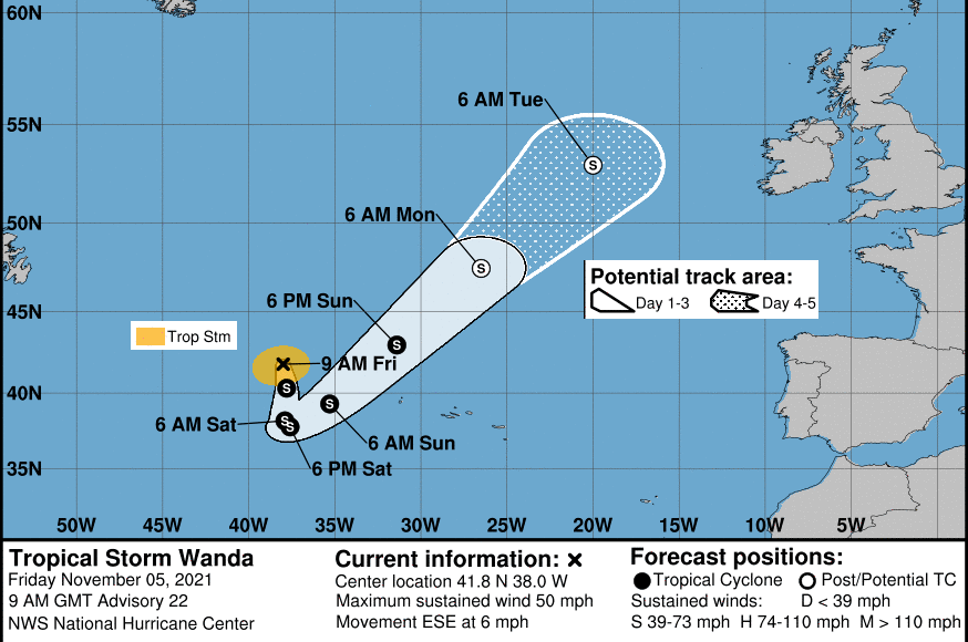
This energy will add some extra oomph to the weather systems approaching the UK from the west and southwest. The low centre near Iceland should give strong winds to NW UK but ex-Wanda could bring a spell of heavy rain, but confidence is low at this stage.