All parts of the UK will be under the influence of low pressure as we end the weekend.
After an extra hours sleep, you'll probably want to stay in bed when you pull back the curtains this morning in what is a dull, wet start for most. But although very unsettled, October is ending on a more mobile note clearing the persistent heavy rain of the past few days from Cumbria and southern Scotland. Nevertheless, we still have some serious flooding issues here, with another yellow Met Office warning of heavy rain today for these parts, together with much of Wales and East Scotland.
The North and East of Scotland have begun mostly dry, but all parts will be under the influence of an Atlantic depression that'll move close to Northern Ireland through the day. As its attendant fronts sweep North and East across the country, it'll be windy, with some heavy rain. But it's already brighter in the West, this quickly spreading to most parts to leave an afternoon of sunny spells and scattered blustery showers. These will be heaviest and most frequent in the West, giving local thunder, with northern Scotland ending the day on a wet note, after the mostly dry start.
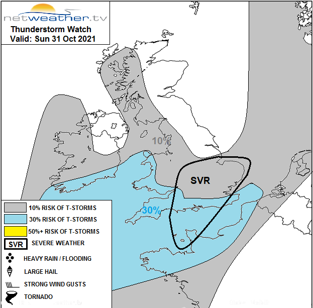
A convective and storm forecast has been issued for today, with some severe conditions possible.
Winds may become lighter across Northern Ireland for a while, with a fresh or strong South or South Easterly wind in the rain, veering South West as the weather clears. Gusts up to 50mph are likely over parts of Scotland and in the West, but despite this, top temperatures of 10 to 13C across the board won't be too far from what we would normally expect.
Hold onto your hats trick or treaters if you're venturing out this Halloween evening, as it'll be windy. But apart from brief passing blustery showers, central and eastern areas should see enough clearances for the door knockers to pick up a few chocolates or sweets on their rounds.
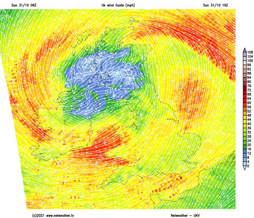
However, in the North and West, the showers will be more frequent, some heavy with a risk of thunder. Here a fresh, strong or gale-force South West wind will give further gusts up to 50mph. This'll make it feel chilly, but generally, there'll be enough wind to prevent temperatures from falling below 7 to 9C.
The new working week ushers in November, renowned for its fog and gloom, but tomorrow is a bright 'n' breezy day. There'll be sunny spells, especially in central and eastern areas where blustery showers will be fewer. The North, West and South coast see the heaviest, most frequent showers with a chance of thunder, some of them lengthy over Northern Ireland and Cumbria. A fresh, gusty and chilly South West wind gives further gale force gusts in the North and West, with maximum temperatures of 9 to 12C.
After dark, it remains much the same, with central and eastern areas seeing clear spells. There continue to be blustery showers, mainly across the North and West and in the English Channel, where some may continue to be heavy with a risk of thunder. A West or South-West wind remains quite blustery and, while helping to prevent temperatures from falling too far, will feel cold, with temperatures perhaps falling as low as 4 or 5 in some sheltered rural 'hollows' to the East of the Pennines.
A cold snap mid-week brings the first slight frosts for some, with showers perhaps turning wintry for time over northern hills. But the cold snap will be brief, with Atlantic air returning into next weekend when unsettled windy conditions return after a drier interval in the South.