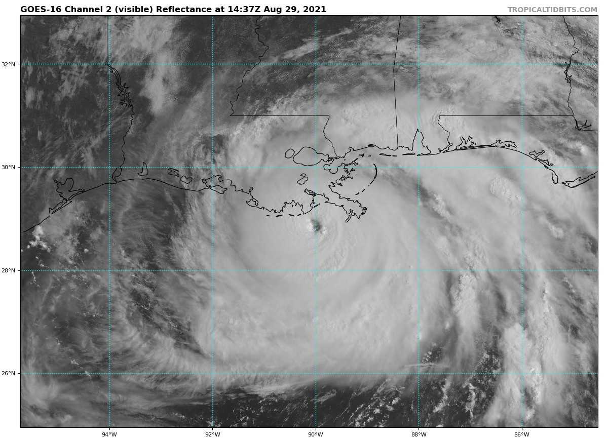
Hurricane Ida, with sustained winds of 150 mph, makes landfall across the coastline of Louisiana Sunday, bringing catastrophic wind damage, storm surge and life threatening flash flooding from over 10 inches of rain.
The outer bands of Hurricane Ida, a high-end category 4 storm, are beginning to sweep heavy rain across Louisiana, as sustained winds reach 150mph, just 7mph shy of being a category 5 hurricane. However, the latest recon suggests Ida has undergone eyewall replacement, which suggests a stalling of intensifying further. But this will be too late to lessen the catastrophic impacts along its path in the coming hours.
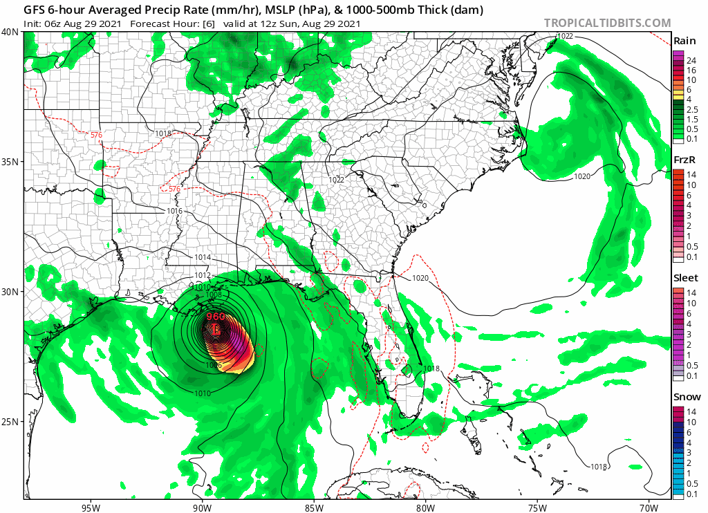
The centre of Ida, as of 3pm BST was 40mph south of Grand Isle in the Mississippi Delta in Louisiana, with a central pressure of 933 mb and is expected to make landfall near Port Fourchon LA late morning local time.
Ida could be the strongest hurricane ever to make landfall in Louisiana. Only two other hurricanes in recorded history have hit Louisiana with sustained 150mph winds, these were a hurricane that hit in 1856 and Hurricane Laura that made landfall on the 27th August last year. If Ida strengthens further by landfall, this will make it the strongest hurricane to hit Louisiana.
Hurricane force winds extend up to 50 miles out from the storm centre, with sustained winds of 115-150mph and gusts of up to 185 mph. The centre was 90 miles SSE from New Orleans or 40mph offshore from the coast as of 3pm BST, so hurricane force winds are beginning to be felt across the Mississippi Delta south of the city. Catastrophic wind damage is likely near where the core of Ida moves ashore along the southeast coast of Louisiana.
A storm surge from the Gulf of Mexico is already inundating areas south of New Orleans ahead of the arrival of Ida along the coast in the next few hours. A catastrophic storm surge of 12-16 feet is expected along the central to southeast coast of Louisiana, 6-12 feet either side along western coasts of Louisiana and the coastline of Mississippi state. A storm surge of 3-6 feet possible as far inland as New Orleans Metro area and Lake Pontchartrain to the north of the city. Though it is hoped that city levees rebuilt around New Orleans since the devastation caused by Hurricane Katrina 16 years ago should hold back any storm surge. Though local levees may be breached in more rural areas of Louisiana causing flooding.
Up to 10-15 inches of rain is forecast for the New Orleans area of Louisiana by the U.S. National Weather Service. This is likely to lead to life-threatening flash-flooding, particularly in urban areas, with the threat of flooding extending further north across Mississippi, Alabama and Tennessee after Ida makes landfall and continues to track north and weakens.
Residents of New Orleans that haven’t evacuated have been told to stay indoors by authorities, with it too dangerous to venture outdoors for anyone. Thousands evacuated the city on Saturday ahead of Ida, with slow-moving vehicles lining for miles Highway 90 out of the city as people fled the storm zone.
Ida’s impacts will continue to be felt as it moves inland, as although it will quickly weaken in strength meaning winds will weaken considerably as it moves inland, the storm will produce heavy rainfall across the lower portions of the central Gulf States through Monday, continuing the threat of life-threatening flooding. Significant flooding impacts could also extend further north across the central Gulf States and across Tennessee and Lower Ohio Valley into Tuesday, as Ida moves northeast.
Loading recent activity...