


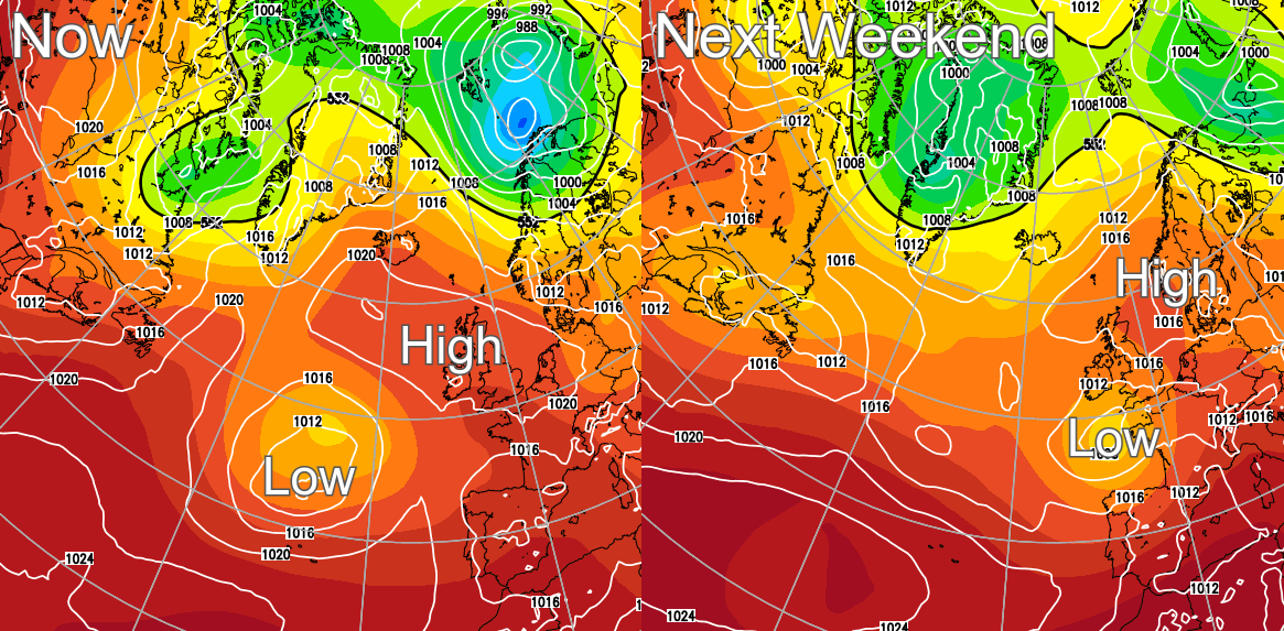
High pressure continues to rule the UK's weather, giving us heatwave conditions at least until the end of the week before things begin to break down.
High pressure continues to rule the roost, giving us at least until the end of the week before things begin to break down. So we have more of this lovely high summer weather to enjoy, before initially mostly the South West and South see showers some heavy with thunder. Over next weekend these become more widespread, bringing a drop in temperature, although the northward extent of this is uncertain at the moment.
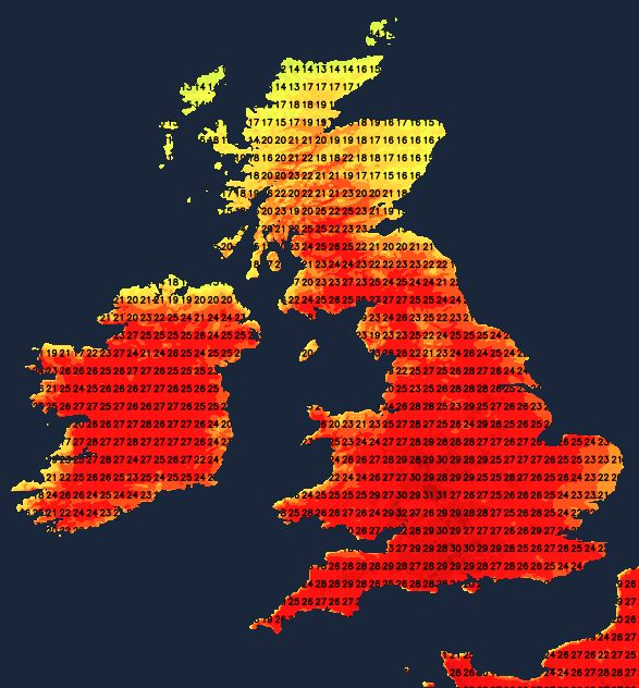
In the meantime, temperatures continue to approach or exceed the magical 30C mark (86F) in 'old money' mainly across southern, central and western parts of England and Wales. So most parts can expect another glorious day to begin the new working week, once patchy cloud has cleared from parts of East Anglia and the North East coast. But remember to 'slap on' lots of cream and wear a hat to protect yourself from the strong sunshine.
The exception will be northern Scotland, where the cloud could be thick enough to give a little drizzle. But further East and South, there'll be sunny periods, with the best of the sunshine to the south of the Central Lowlands Top temperatures 15 to 18C in the North but 23 to 26C towards Lothian and The Borders. Across England and Wales, another hot or very hot 26 to 30C will be 'nearer the mark', where some cloud will build later 'triggering' the odd sharp shower or thunderstorm, but you'd be very unlucky if you caught one. A storm forecast has been issued for today, with more information on the thunderstorm risk.

The North of Scotland continues to see cloud and patchy drizzle, but elsewhere, a lovely, very warm high summer evening will follow, with any showers fading towards dusk. Largely clear skies and light winds after darks allow a few mist or fog patches to form in rural areas, but these will quickly clear after sunrise. During a humid night, difficult for sleeping, temperatures fall no lower than 13 to 16C and 17 to 19C in the South.
With a large anticyclone continuing to dominate, Tuesday remains as you were across much of the country. The far North continues to see cloud and a little drizzle in places, with a few patches of very low cloud along some North Sea coasts soon clearing to leave another fine, sunny day leading to another hot, sweltering afternoon in generally light winds. The vast majority stay dry, but again some cloud will build to produce isolated sharp showers. The odd thunderstorm could give a very localised torrential downpour late afternoon, but the chance of catching one remains small. Top temperatures again mostly between 26 and 30C, with sea breezes keeping some coasts refreshingly cooler.
Another very warm, barbecue summers evening will follow, with any showers melting away after dark. In another humid, largely clear night, mist and patchy fog may form somewhat more widely, with perhaps some North Sea coasts seeing mist and grey skies by dawn. The 'sticky' conditions will make it uncomfortable for sleeping again, with temperatures unlikely to fall below 14 to 17C and 18 or 19C in the South.


