


The forecasting models currently suggest a lot of dry and settled weather through June, as the theme of 'stuck' weather patterns continues.
It seems the weather patterns over recent months get stuck in patterns that feature either extremes of dry or wet. Indeed, the last few years have seen whole months dominated by blocking, bringing weeks of dry weather. While some months have been stuck under the jet stream, bringing relentless rain.
The last two months definitely bear testament to this, with April record-breakingly dry, sunny and frosty, May seeing high rainfall (wettest on record in Wales) and low maxima. Though, bucking the trend of recent years, both months were below the long-term average temperature-wise. Now it seems, after the cool and wet May, that June flips to a mostly warm, settled and dry outlook – certainly looks that way for the first half of the month, but perhaps even into the second half.
For the rest of this week and through the weekend, the flow across the UK will generally be slack and weakly anticyclonic, so for many, it will be fine, dry and bright or sunny for much of the next 4 days, though is a chance of a little rain in the east tomorrow, along a reactivating front here and a few showers in places over the weekend too – but nothing approaching a washout for most. Not as warm as the last few days, but temperatures reaching the high teens to low twenties – which is around average for the time of year. Nights could turn chilly though across northern and western areas.
Some rain in the east on Friday, showers in the northwest on Saturday and isolated showers for England & Wales on Sunday, otherwise dry and sunny for many over the next 4 days - as high pressure stays generally in control.
High pressure looks to weaken somewhat on Monday, with pressure dropping enough from the west to allow more in the way of showers, locally heavy with thunder, to develop across England and Wales. Showers or longer spells of rain may affect Scotland, N. Ireland and Ireland Tuesday and Wednesday, as Atlantic fronts brush here along with a freshening southwesterly wind. But further south, high pressure looks set to re-establish from the southwest – with a return of fine, dry and sunny conditions for much of England and Wales. Temperatures look to be on the up too, perhaps the mid-20s Celsius on Wednesday in the southeast.
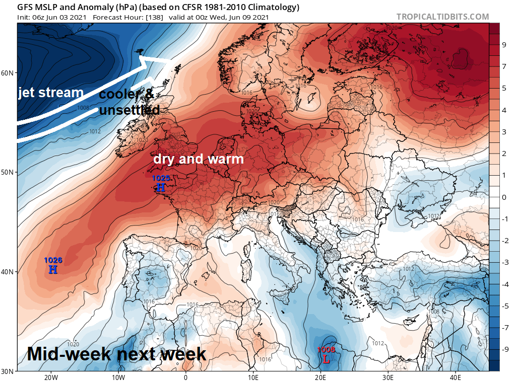
As a strengthening jet stream close to Scotland begins to lift north towards the Faroes by the end of the week, a corresponding strengthening upper-level ridge looks to extend from the Azores northeast across southern Britain and northern France by Friday. This will see a corresponding rise of surface pressure with fine, dry and sunny conditions, building north across much of the UK and Ireland by the end of the week, banishing any rain across Scotland by then. With a generally westerly flow, we’re not looking at a heatwave by any means, but current models forecast suggest temperature into the low 20s to mid-20s towards the southeast.
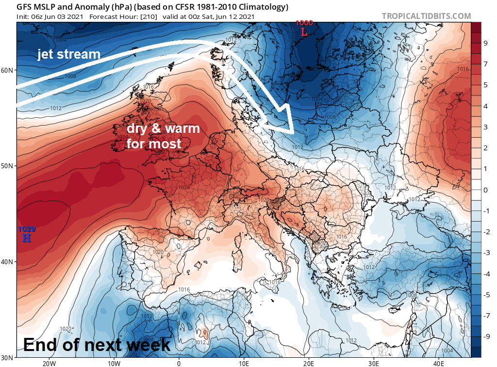
Some uncertainty, given the timescale in the future where upper-level ridge close to the south goes as we reach the weekend of the 12/13 June. 00z EC this morning wanted the upper level high to drift northeast towards Scandinavia by day 10 (Sun 13th) – while pressure falls to the west and southwest – the UK still dry but with the threat of thundery showers into the far south. While the 06z GFS retreated the upper high back southwest by day 10, followed by a drop in pressure and more unsettled conditions from the north with a northwesterly flow into the following week. The 00z GFS keeping ridging across the south day 10, but eventually, a cooler and unsettled northwesterly flow taking over the following week.
Some uncertainty between 00z operational runs of EC and GFS (top two charts) for day 10 / Sun 13th June. EC and GFS ensemble mean offers more agreement of high pressure close to or just west of the UK.
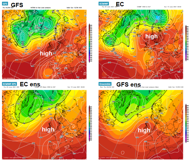
With the uncertainty, as often is the case, it’s worth looking at ensemble guidance. So analysing the 00z EPS clusters, there appears good support for an upper-level ridge (red) to be over or close to the UK at day 10 (Sun 13th June).
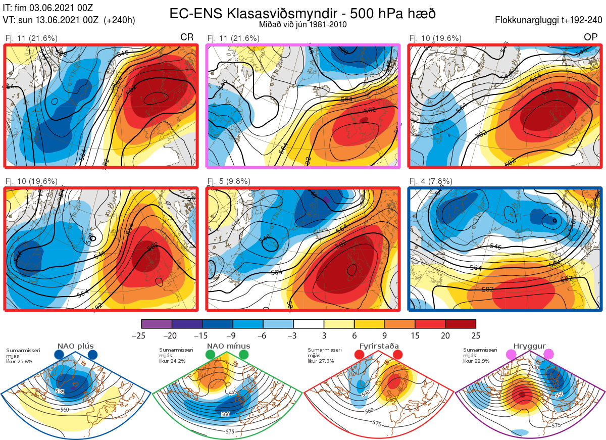
Going further ahead, and EPS clusters past mid-month for Friday 18th, it still looks like an upper-level ridge will be close to or over the UK.
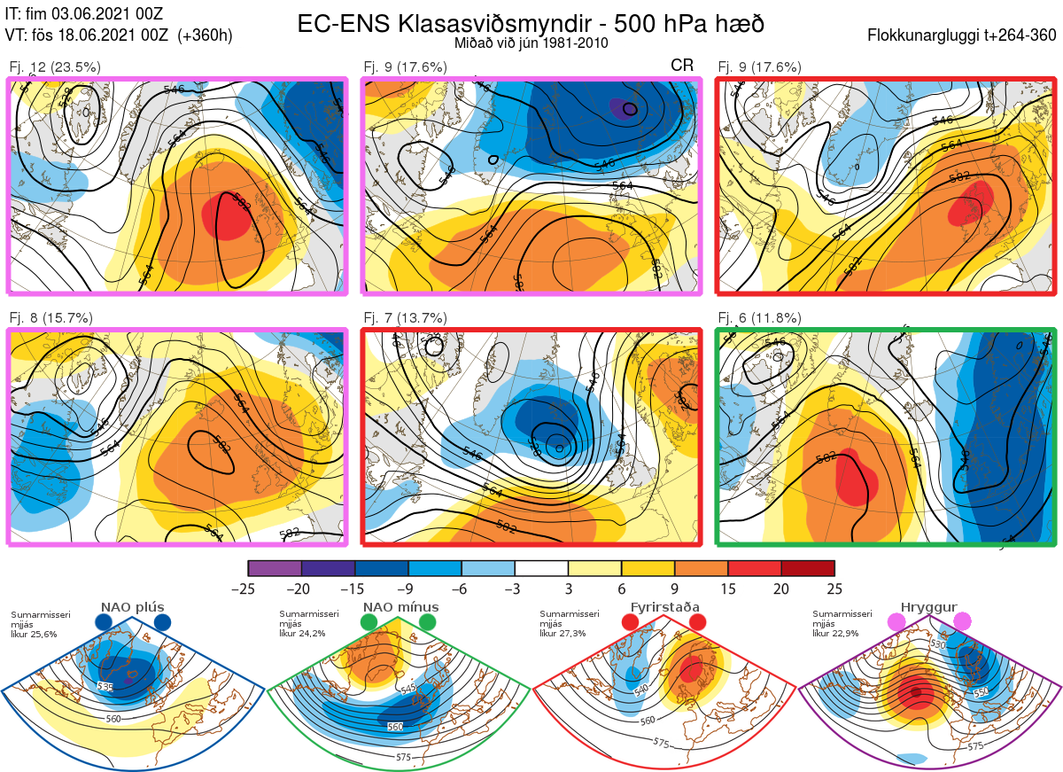
Normally, the upper-level ridge would need to be over continental Europe and low pressure to the west or northwest for heatwave weather. But the EPS clusters do not suggest this positioning of the upper level high, so although it indicates predominantly settled and dry conditions over the UK could persist past mid-month, it doesn’t look like it will be really hot in the 30s, more pleasantly warm.


