


A look at the UK weather in the week ahead with a video forecast by Jo Farrow. Heavy showers continue to bring a flood risk before a large low pressure heads in from the Atlantic
The UK is finally facing a change from the thundery downpours in over a week of warnings. The heatwave conditions have eased and by the middle of this week, it will be an Atlantic low pressure dominating the scene with blustery winds.
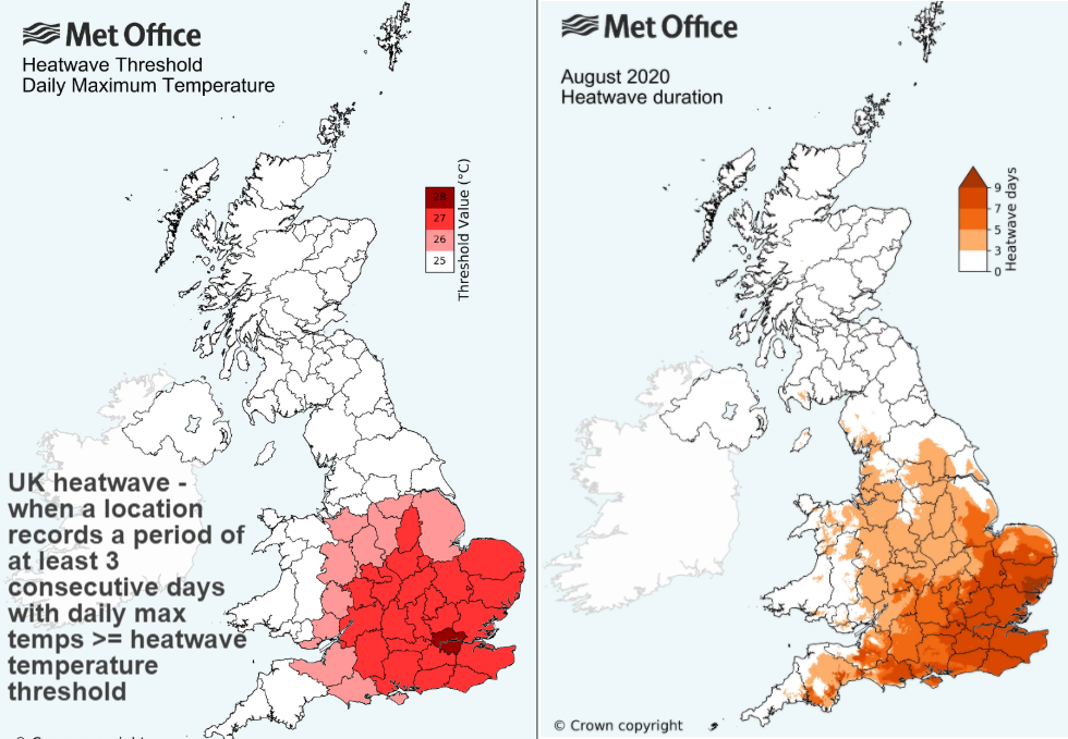
The UK heatwave saw a peak of 36.4C on Friday 7th August at Heathrow, a week after the 37.8C (100F) on the last day of July. Six consecutive days of at least 34C and three consecutive days of over 35C. Temperatures this week will be in the high teens and low 20sC with the humid muggy conditions easing particularly in the west.
The thunderstorms were spectacular but disruptive. It is unusual for the UK to see such a long spell of heat at the level of mid-30s and unusual to have such severe storms.
The slow-moving storms caused torrential rain and flash flooding. This led to travel disruption and damage. Edinburgh and eastern Scotland saw an incredible lightning show on Tuesday 11th night as heavy, thundery rain just kept on coming, moving northwards and resulting in flooding. Part of the A68 was washed away, cars floated in a Kirkcaldy hospital car park and there were landslides linked to the tragic train crash near Stonehaven. The M25 was closed in Surrey and there were rail cancellations on Thursday 13th with flash flooding in Wellingborough Northants, and Peterborough Cambs.
The cellular nature of showers and thunderstorms meant that one area could be hit by torrential downpours yet nearby people saw very little, or just lightning and a cumulonimbus anvil in the distance whilst keeping the sunshine. Some people who didn’t get a storm questioned the ongoing blanket yellow warnings but for now, modelling of exact location and timing of thunderstorms is not detailed enough. And if you watch some of the footage of crazy hail, gusty winds or lashing rain then you will see those impacts were quite something, if still unlikely in any one location.
“Possible impacts could include significant travel disruption, flooding affecting properties, communities and key infrastructure. Due to the localised nature of the heaviest showers, impacts may be isolated with not all locations being affected. Remain vigilant.” SEPA
On Tuesday there will be heavy showers over Northern Ireland, the far north of England and particularly Scotland where there is a yellow warning for rain in the afternoon. There has already been heavy rain today so widespread flood alerts have been issued for much of mainland Scotland in preparation.
As we change from individual storms to frontal systems, the risk of flooding remains. This time, it will be around the coasts of SW Britain as the Atlantic low heads in. This low brings in the fresher conditions and also the windy weather.
From Wednesday onwards, local coastal flooding is possible for parts of the south coasts of Devon and Cornwall and the Dorset coast, and from Thursday is also possible for the south coast of Wales and parts of the Bristol Channel. This is due to the potential for high tides to combine with strong winds and large waves. Land, roads and some properties may flood and there may be travel disruption. Environment Agency
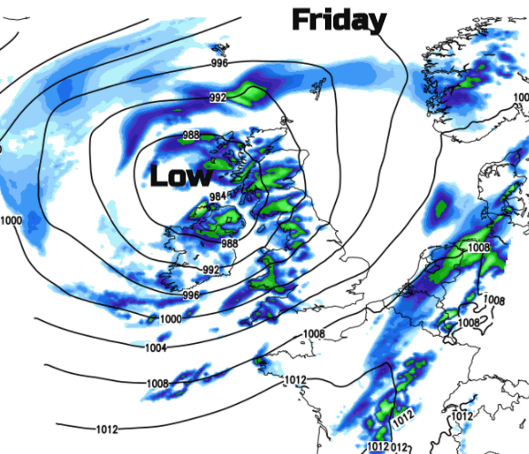
This end of week low pressure contains the remnants of Tropical Storm Kyle. At this time of year, the Met Office/Met Eireann/KNMI project (if that still exists) wouldn’t be naming “storms”. It is just a large, unusual for the time of year, low and a significant change from the weather that we have been seeing so far in August.


