


Forecast for the UK as the risk of thunderstorms continues, as does the heat. Includes video with Jo Farrow.
Updated Tues 11th 11:50
There is a UK wide thunderstorm warning shown in Tuesday's new convective forecast and on the yellow warning from the Met Office (that one will be updated at some point today). An area over Scotland, Cumbria and the Isle of Man has been highlighted in blue with forcing here which...
" will bring areas of elevated heavy showers and thunderstorms N here through the morning and into the afternoon before clearing late afternoon, some of the storms could be accompanied by frequent lightning, hail and torrential rain leading to localised flooding. "
This week's forecast is facing a balance of the low likelihood of a thunderstorm being in your location overall, against the impacts if one does arrive. Such as large hail, strong or gusty winds, frequent lightning. They continue to move northwards into Scotland early Tuesday.
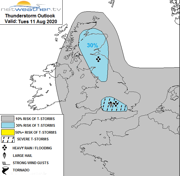
Any severe thunderstorms could bring local or flash flooding, also disruption to travel and power supplies. There was heavy rain overnight as pulses moved northwards and Snowdonia saw large hail on Monday. We don't often get severe thunderstorms here in the UK but the various ingredients are coming together as the UK continues with high temperatures and heatwave conditions in the south.
The Met. Office has issued four days of thunderstorm warnings across nearly all of the UK, adding in more detail each day. The Environment Agency has followed the broad brush warnings with four days of highlighted low risk of "local flooding". The convective forecast from Monday morning has more technical detail.
It is still difficult to pinpoint which locations will get the heavy showers and thunderstorms which is why large areas are highlighted. Again today there will be areas with thunder, heavy downpours and places which don't see any rain at all. But the higher end of the risk has to be considered and shared, so that people can make decisions about their day and property.
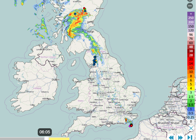
Watching the rain radar, the satellite cloud imagery and the lightning sferics can become almost hypnotic in these setups. And we have several more days and nights of thunderstorms to come.
We are midway through a week of UK temperatures reaching over 33C. This also doesn't happen very often. Unusual, extreme weather. Temperatures around 37C are forecast for SE England inland Tuesday or Wednesday as a maximum. That is near to the all time UK record.
Public Health England continues their Heat health warnings for southeast, southern and eastern England. And an alert across the Midlands which could be upgraded to a warning midweek. It prepares health and social workers to consider high-risk groups. The heat, especially as it lasts by day and night can cause stress or add to pre-existing health conditions. Air pollution levels have also been rising during the late afternoons, as Ozone forms in the sunlight. This has been an issue for some spots in SE Britain over recent days.
So quite a week with more thunderstorms to come and the ongoing heat. It should all ease by the weekend.


