More hot weather to come today and into next week, with an increased risk of thunderstorms from later today as well.
Altocumulus castellanus is a lovely small cloud to look out for that's been common over the past few days. They have castle-like turrets and flat bases, regularly taking on a dappled structure as if someones been across the sky with a paintbrush. Seen mostly during hot weather they produce little rain but are a precursor of thunderstorms. And, with a thundery low set to move North from France, the threat of heavy showers and storms will become more acute into the new working week.
Many central and eastern areas are waking to grey, misty start, with murk off the North Sea extending as far West as Wales overnight. There's also been a little drizzle in places with the murk taking a while to clear from some parts, before 'burning' back to the coast. You'll then join much of the country in another mostly fine day, with sunny spells. Some cloud will build later to perhaps 'trigger' the odd sharp shower we've already had a few across the South East, but most parts stay dry.
A storm forecast has been issued for today.
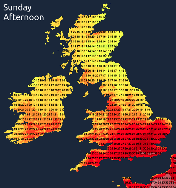
It'll become very warm or hot and humid again, with a sizzling 32 or 33C over (90F) likely to the West of London and over other parts of the South and South East. Across much of England and Wales, temperatures will reach 22 to 28C, but a North or North Easterly breeze will keep North Sea coasts and some places further North cooler.
You could catch an isolated sharp shower or a thunderstorm almost anywhere into a warm evening, especially across the South and West. The odd storm could 'rumble on' into the night when areas of mist and low cloud return to many central and eastern regions on a North Easterly breeze. Northern Ireland and the West see clear spells, with a few sheltered Highland glens of Scotland turning a little chilly towards dawn. For most though and particularly the South it'll be another humid night, with lowest temperatures 16 to 19C in the South, but more generally 11 to 14C.
Central and eastern areas begin the new working week grey and misy again, but as on Sunday, this'll eventually burn back to the coast. Any residual showers should soon clear, then most parts become very warm or hot again, with hazy sunny spells. Cloud amounts will vary with a somewhat better chance of catching a heavy perhaps torrential shower or thunderstorm, most likely over Wales and the South West. In another humid day, temperatures reach 25 to 28C locally 30C plus again in the South and West. Further North and East, however, 19 to 24C is more likely, with an East or North Easterly breeze keeping North Sea coasts cooler and fresher.
The West and later Northern Ireland seem most prone to catching a heavy shower during the evening. Still, almost anywhere could see a thunderstorm overnight, when mist and areas of low cloud return to many central and eastern regions. Despite an East or North Easterly breeze, it'll be another humid night, especially in the South, with temperatures generally not falling below 11 to 18C.