There'll be some sunnier spells of weather during the next few days but don't let them lull you into a false sense of security as a heavy, even thundery showers could come along any minute.
The weather continues unsettled with a mixed bag across the country, but it will be turning warmer and more humid into the weekend. There'll be hazy sunny intervals but don't let these fool you, as you could suddenly be caught by a sharp shower. So if you're venturing out in the next couple of days, keep an eye on the radar before you leave and take an umbrella just in case.
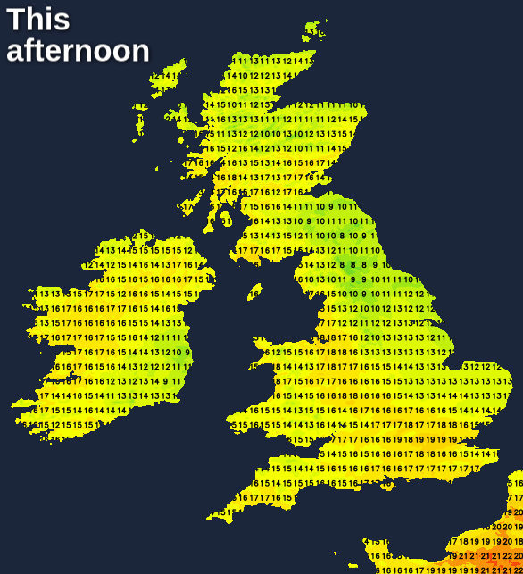
It's a grey start except across the North and North East of Scotland, with the North and West of Scotland seeing the best of the sunshine today where it'll be mainly dry. Elsewhere it's mixed, with heavy overnight rain eventually clearing from the South West. There'll be a lot of cloud across the country, but also hazy sunny intervals. Showers are likely; we already have a few sharp ones over East Anglia moving into the Midlands, with more of them coming from the East through the day. Some will be heavy with a few thunderstorms by the afternoon, mostly in the South. Later eastern counties North of The Wash and perhaps the Scottish Borders see more persistent rain.
A storm forecast has been isssued for today - read it here.
The main difference you'll notice from yesterday will be a brisk North Easterly wind that'll give gusts of 35 to 40mph along exposed North Sea coasts. This'll keep it cooler here, with top temperatures elsewhere mostly between 14 and 20C depending on amounts of sunshine that'll vary widely.
It remains unsettled into the evening, with wet weather across the North East spreading to most of northern England and the Scottish borders overnight. Elsewhere the heavier showers should fade, but you could still catch one at any time. After dark, the Midlands and East Anglia, in particular, will see areas of low cloud moving in from the East, making it misty and murky in many places by morning. Meanwhile North and West Scotland should continue mainly dry, with clear intervals.
A North East wind remains brisk, especially along North Sea coasts. In the far South and across the Channel Islands you may see heavy, thundery rain towards dawn, ahead of humid air moving up from northern France. In a mild night though temperatures fall no lower than 9 to 12C in the North and 13 to 16C further South.
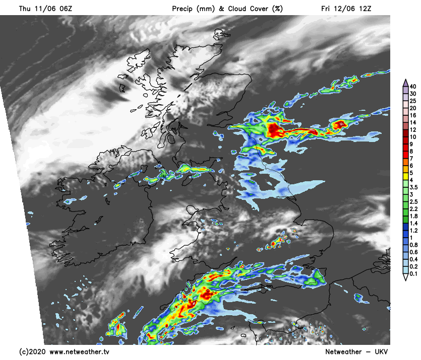
Friday should see a band of heavy rain, probably with a few thunderstorms, moving North to affect mostly across southern England, Wales and the Midlands. Elsewhere there'll be a lot of cloud, in a dull, misty start especially over East facing slopes of the Pennines. There'll be further showers 'dotted' about, with much of Northern Ireland, southern Scotland and the North of England starting wet. Meanwhile, the best of the sunshine remains over Highland and the far North, with south England probably seeing a few sunny intervals later.
The brisk North East wind should decrease in the South, with top temperatures 14 to 20C. In the South, however, a more humid 21 or 22C is possible, with perhaps a few heavy showers developing across the Channel Islands and South of the M4 later.