In the past week, one side of the Atlantic has experienced unusually high pressure, beating records in places, with clear blue skies and sunshine. The other side has seen severe winter conditions as temperatures plummeted in 24 hours and a winter storm dumped record amounts of snow on Newfoundland.
Whilst people in NW Europe have been wondering if headaches and funny earaches are linked to the intense high pressure or their television signal has been a bit ropey, Newfoundlanders have experienced several days in a State of Emergency and are still digging out of their homes and cars.
So, are we going to see some of this North American snow here in the UK? Is the extreme high pressure responsible for headaches and your Freeview picture faltering?
Earlier in January the UK had been bombarded by numerous low pressures with wind and rain then more rain. The zonal jet stream was zooming right across the Atlantic, strong and straight. It deepened low pressures and brought them right across the UK, moving by quickly. One of these was named Storm Brendan by Met Eireann and brought wild conditions to Ireland and parts of the UK.
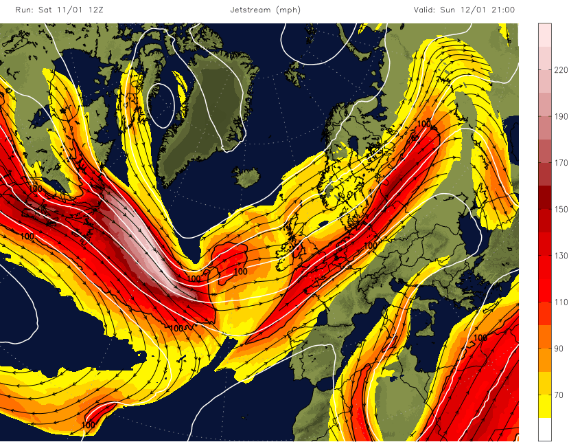
Across in Northern America, there was a huge temperature contrast NW to SE which brought tornadic storms along the frontal boundary then heavy snowfall as the system moved eastwards. This large temperature contrast made the jetstream more energetic and as two low pressures combined Newfoundland was hit by an intense winter storm.
It resulted in a state of emergency and a major dig out. This major winter storm saw blizzard and storm surge warnings being issued. Then the snow came, burying cars, roads, and fronts of houses. The amusing Newfoundland Doors threads showed locals opening their front doors after the storm to a complete wall of white. Thousands remain without power and St. John's, the capital of Newfoundland recorded 76.2 cm (30") of snow on one day with wind gusts of 80mph. That’s quite a blizzard. The snowfall was a new all-time record for most snow in one day for St. John's International Airport. Canadian troops have been sent to help clear the snow after the massive blizzard.
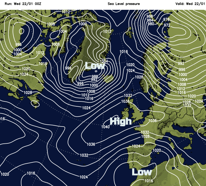
In-between with warm air being advected north, an upper ridge formed, air began to converge and in relative quiet, the large high pressure continued to build. This left a huge meander north/south in the Jetstream across the Atlantic ahead of the Newfoundland storm which forced another low pressure down towards Iberia. You can see the cut off low related to Storm Gloria. This is still bringing huge waves and heavy rain, even inland snow to eastern Spain this week.
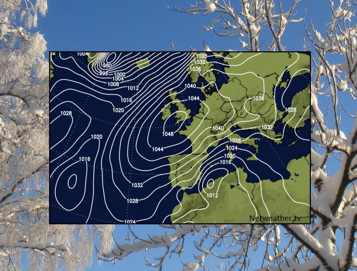
So, the High pressure. It isn’t too important in weather impact terms as it brings settled conditions but weather people like their statistics and records. The UK record is 1053.6hPa from Aberdeen Jan 1902 which wasn’t really under threat but tipping over into 1050hPa does not happen very often here. The cold winter air cooled even further overnight under the clear skies as the high built. This made the air even more dense and pressure increased further, hence the winter phenomenon of big number highs. On Sunday 19th Jan 2020 Mumbles Head in south Wales saw 1050.5hPa.
.png?w=686)
A hectoPascal is the metric measurement of Atmospheric pressure and equates to one milliBar. 1 hPA = 1 mBar. The UK hasn’t seen over 1050 in over 60 years. London also experienced its highest air pressure in 300 years. Heathrow recorded 1049.6hPa with London records dating back to 1692.
It looks like pressure records have been broken in France and Belgium, although not as high as over the UK. 2020 high record France 1049.7hPa in Abbeville, northern France
High pressure can lead to interference for television and radio signals. With cold air at the surface and warm air above, a temperature layer called an inversion forms and this adds to issues with the propagation of the signals. Television companies often get phone calls from viewers in high pressure situations, complaining that the signal is breaking up.
From Storm Brendan to the NW of the UK on Tuesday 14th at 940hPa to the weekend high of 1050 centred over south Wales we have seen an extraordinary pressure change in 4 days. There are investigations that low pressure and pressure changes can lead to headaches but no real evidence about intense high pressures.
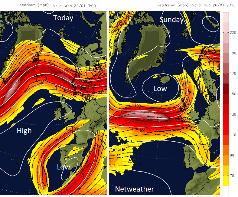
The huge snowfall from the US and eastern Canada is not heading to the UK. Greenland and Iceland have seen windy winter weather. The winter Storm only impacts NW Europe indirectly by changing atmospheric patterns downstream. The jet stream looks set to move back south this weekend as the high pressure fades across the UK. So back to wet and windy weather from the west with a bit of hill snow.
Loading recent activity...