VIDEO - High winds and heavy rain are arriving thanks to Storm Brendan. Jo has an update about today's main weather event with gales, coastal flooding and hill snow in the forecast.
For the start of the working week, we have two low pressures heading towards the UK, set to bring severe weather. For Monday, Storm Brendan, a low undergoing Rapid Cyclogenesis (RaCy), deepening quickly already bringing gales, high gusts and heavy rain to Ireland then the UK today from the west. After that, another low swings up from the SW and there are warnings for strong winds for England and Wales on Tuesday. Hold onto your hats!
Bantry in Co.Cork. #StormBrendan

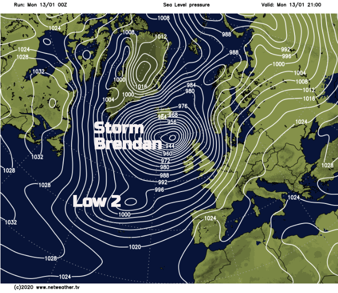
The weather in the US has been quite severe and unusual. Bitter winter cold from the north and west over taking very mild conditions in the south and east. As the two air masses collide, there have been storm warnings and a risk of tornadoes and with all the January darkness this brings an extra risk by night. For the UK weather, this huge temperature contrast has resulted in a powerful Atlantic Jetstream coming out of North America and deep low pressures coming our way. The deepening of Storm Brendan will lead to the phrase “weather bomb” to be bandied about. It is undergoing much more than “a fall by 24 millibars in 24 hours”, the criteria for explosive cyclogenesis.
Storm Brendan
Rain - There is an occluding frontal band running north-south from the low which will move across Ireland and Northern Ireland later morning, lunchtime and clears for the first part of the afternoon. Patchy rain reaches western Britain by midday, but it will be the back edge of the frontal band and embedded line convection that will need watching out for as this moves across Britain mid-afternoon and through the evening rush. These torrential downpours will bring poor visibility and spray on the roads, surface water flooding and completely soak you if you are caught in them.
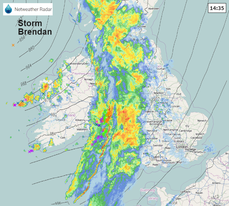
Look at the Netweather Radar if you have to pop out today. The worst of the heavy rain will be away from eastern Scotland this evening but continues to move eastwards across SE Britain, not clear of Kent even by midnight.
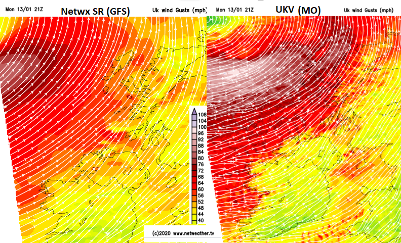
Winds - The main area of strong winds hits Ireland and Northern Ireland this morning, southerly with gusts around 60mph. These veer to the SW as the front passes and ease for a time. The strong winds move over Britain with gusts of 50 to 70mph mainly for western Britain and Scotland. By this evening it will be windy for more of England, along the English Channel from S/SW and through the Irish Sea.
As the bent-back occlusion and low centre slide past to the NW of the UK even stronger winds are forecast. It could be a stormy night for the Western Isles as wintry showers rattle in depending on how close the low centre gets to NW UK before heading away northwards.
Ireland is covered with Orange warnings today for the winds. Northern Ireland, western Britain and NE Scotland including the Northern Isles have a yellow warning for winds. Last Tuesday’s strong winds were westerly, today’s area from a different direction.
“The strongest winds are expected around exposed coasts and hills. Here gusts of 60-70 mph are likely, with a few sites perhaps seeing gusts to 80 mph - especially around Irish Sea coasts and around the west coast of Scotland.” Met Office
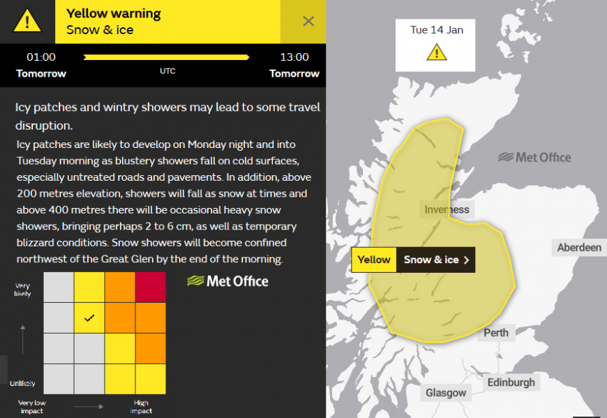
Snow- As the heavier rain moves across Scottish mountains, even north Pennines, Cumbrian Fells there will be some snow today and snow showers following tonight. Also, a little possible for the hills of Northern Ireland and Snowdonia. Warning for Snow and Ice out from UK Met Office as showers move in from the west.
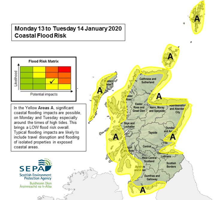
Flooding - “There is a significant risk of coastal flooding due to the combination of high spring tides and storm surge.” Met Eireann. “Remember to Stay Back, Stay High and Stay Dry!” Irish Coastguard. The Scottish Environment Protection Agency has also issued advice “Coastal flood risk along mainland and islands coast lines from Monday. Wave overtopping expected and large storm surge raising high spring tides. Be prepared.“ SEPA.
After a slight lull (away from the strong winds and snow showers for NW Scotland), a new low pressure heads up from the SW on Tuesday morning. This will bring strong wind and high gusts into Devon and Cornwall by lunchtime with rain ahead of the winds. There is much milder air within this system, temperatures rising into double figures for southern Britain. However, with colder air away to the north there could be a little hill snow as the rainband moves north through Britain and clips Northern Ireland. The strong gusts SW winds should take hold over Wales and England later on Tuesday afternoon and again for the evening rush hour.
There is a yellow warning for the winds from the Met Office “Strong winds will develop on Tuesday which may bring some disruption.” We’ll have to see how this wave develops once Storm Brendan is done, but today’s weather looks to be the main event of this week.
More chat about #StormBrendan on the Netweather Forum
Loading recent activity...