A roundup of the events and incidents as Storm Doris hit the UK today bringing gales, high gusts, heavy rain and snowfall.
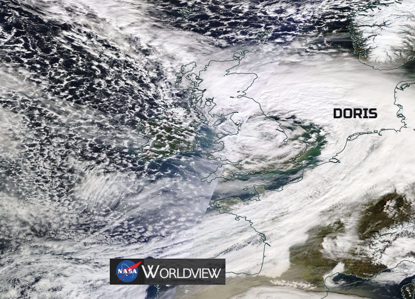
#StormDoris has marched her way across the UK, bringing gales, damaging winds, heavy rain, snow and gusts not far off 100mph.
There has been widespread disruption to travel services, power outages and wild conditions.
Early on Thursday, Scotland saw snowfall through the Central belt with an exciting white blanket outside for some and travel misery for others. The M80, which runs from Glasgow to Stirling and links to other major motorways, was shut due to snow, while there were two jack-knifed lorries near Falkirk.Stranded vehicles forced the closure of sections of the M80 today after heavy snow caused major traffic problems during the morning rush hour. There were rush hour problems as people abandoned their vehicles blocking the gritting lorries from doing their work.
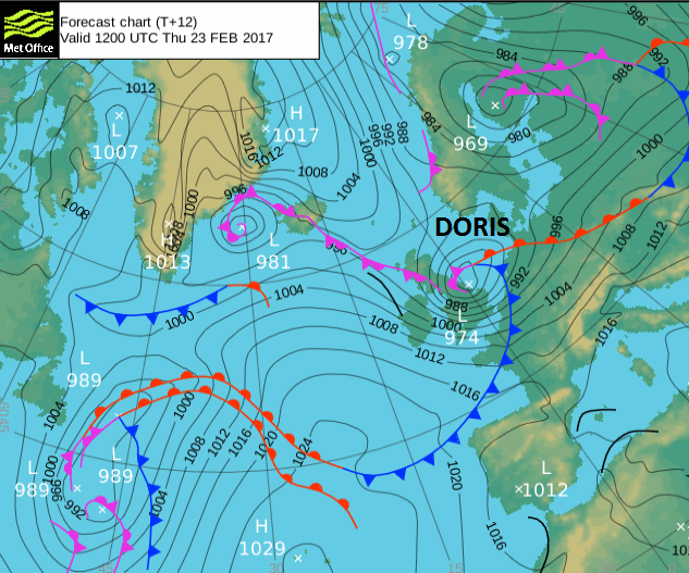
More widespread problems were due to the strong and gusty winds. Some flights and various train services had already been cancelled before Thursday, with Amber weather warnings issued by the Met Office. Storm Doris was a deep area of low pressure which underwent explosive cyclogenesis. This means that the low pressure rapidly deepened dropping by at least 24mbs in 24 hours and had the potential to bring violent gusts to the UK. Hence the severe weather warnings.
The highest gust recorded today was at Capel Curig 94mph, in North Wales. High Bradfield 87mph in the Peak District and Weybourne 81 mph on the north Norfolk coast.
NW England and particularly the Wirral were battered during Thursday morning. Liverpool port was closed as the winds became too dangerous for workers.
Airports
Numerous flights were cancelled or diverted or had tricky landings. Some passengers today must have been glad to touch down in the end after circling around English airspace, but it's rarely a joy to end up miles from where you intended.
Landings suspended for now at Manchester, all flights holding.
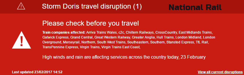
Railways
Train lines were in chaos, today due to the weather. First train disruption with wires down at St. Albans on the Midland Main Line this morning. This was affecting St. Pancras to Bedford services.
All rail lines on The Wirral were closed by fallen trees.
All trains to and from Liverpool CANCELLED. This is due to the failure of the electricity supply.
A tree blocking the railway between Dorchester West and Maiden Newton was causing delays and cancellations.
There was a tree blocking the Wrexham to Bidston railway line at Caergwle in NE Wales and another one in Berkshire .
Heavy rain and flooding added to the upset. Heavy snow had been forecast for southern Scotland but most of this stayed as rain, just not cold enough to turn to snow. There were major delays on the west coast main line due to flooding north of Carlisle.
Flooding also on the east coast main line between Edinburgh and Berwick.
Bridges
A whole host of bridges closed or had restrictions for High sided vehicles
Flintshire Bridge closing now. Britannia bridge has been closed. Orwell bridge has closed.
The closure of the M25 Dartford crossing caused more travel upset in Kent.
Power Outages
The gales also led to power outages in the West Midlands, Lincolnshire and NW England.
Hundreds without power in Stockport, Ormskirk, Poynton, and Macclesfield as power lines brought down in
#stormdoris
Other incidents
Filming for Coronation Street had to be stopped due to the high winds. 'The Street' becoming too windy.
Part of the roof of Lidl in Blackpool blew off
Dudley Zoo was closed and built up areas in the West Midlands were badly affected. Wolverhampton Crown Court was evacuated this morning and Yates Pub Roof blown off in the town. A lady died, allegedly when a sign tragically blew off a shop in the town centre too.
Colwyn Bay Pier suffered further damage due to Storm Doris, with more of the structure falling into the sea.
In Norfolk, eleven people were treated after a double decker bus blew over near Wisbech.The X1 First Bus service blew over between West Walton and Walton Highway.Services between Norwich to Peterborough were then withdrawn until the winds eased.
Even after all of that, the travel misery continues with further reports of trees on train lines, lorries overturned, services cancelled during a busy rush hour period for SE Britain.
There will be more strong winds, gales and high gusts this evening for East Anglia and SE England with further disruption likely. For the rest of the UK, we are left in a cold, gusty NW flow bringing a bitterly cold night with widespread ice.
This will bring tricky conditions on the roads and untreated pavements. Wintry showers are moving down from the NW too.
What next?
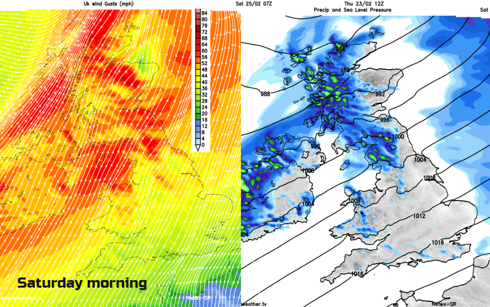
There will be a lull during a chilly Friday before more wet and windy weather comes in from the Atlantic for Saturday morning. Not as bad as Doris but another spell of heavy rain for the north and strong gusty winds spoiling the start of the weekend. It will be blustery further SE but not as windy as the NW half of UK.
.jpg)