


The UK weather will be very unsettled in the coming week, with bands of heavy rain, strong winds and gales and hill snow. The Sunday/Monday low has been named Storm Atiyah by Met Eireann.
A different start this morning, it’s much milder. There have been some stunning sunrises this week. Today, there are two areas of rain; one for SE England and East Anglia which is clearing eastwards and another more showery cluster affecting Scotland and Northern Ireland. Western Scotland has been especially wet with reports of travel disruption and looks very wet this weekend. Met Eireann has just named a low for Sunday #StormAtiyah

This weekend Sunday looks more windy and colder than Saturday, we’ll be back to a frost early next week. An incoming low pressure at the end of the weekend could bring gales, even stormy conditions Sunday night, just something to watch. And then there will be a tuck of colder air and further bursts of wet and windy weather next week, mixed with a bit of a chill.
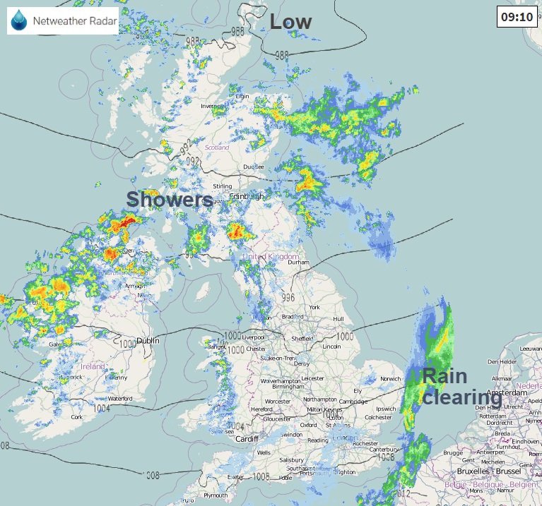
The bands of rain or showers are being pushed across the UK with some gaps in-between and an easing theme today. So overall becoming drier although there will be a cluster of showers moving across Wales this afternoon into the Midlands and at moment forecast to hit greater London later afternoon, hopefully just before the main Friday evening rush. So worth keeping an eye on the radar today, so as not to be caught out by pesky downpours.
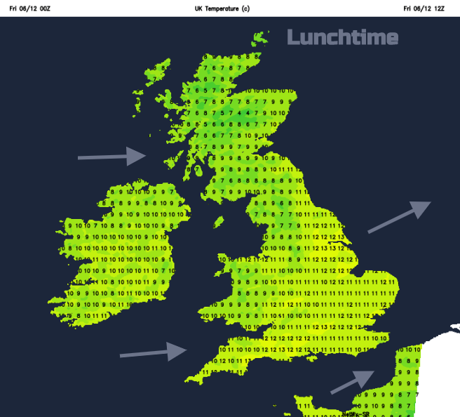
Some places have started the day in double figures, and it remains mild, up to 13C but with a fresh west wind making it feel cooler. Tonight, it will be cold for Grampian, but the rest of the UK stays mild in a light westerly wind. It will be dry for most with clear spells. So, a bit of a lull to start Saturday before the next frontal system heads in from the west. A warm front bringing milder air to Ireland and then an active cold front across Britain for Saturday night with strong winds and some heavy rain whizzing through.
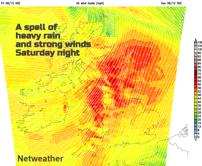
The warm front rain mainly affects western Scotland during Saturday afternoon. For most of the UK, it is a fair day, just a little patchy rain affecting Northern Ireland and afternoon rain for NW England. Saturday evening starts mild, within the warm sector and then a band of heavy rain with strong winds moves in from the west
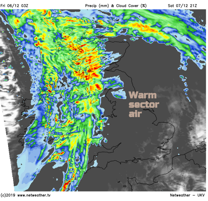
This band is an active cold front. Behind it the skies clear, temperatures fall, from 12C down to 3C. The last of the rain will be clearing from Kent by dawn on Sunday. For Northern Ireland and Scotland there will be wintry showers in the fresh westerly winds. Many areas will see a fine even sunny day, especially for eastern Britain but further west there will be showers with heavier clusters in the afternoon. Northern Ireland and western Britain see more showers, with wet snow over the hills and mountains.
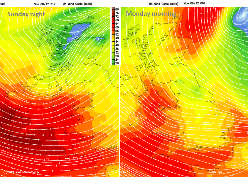
A second low adds into the windy melee of Sunday and could bring stormy conditions to western Ireland later in the day. Gales are forecast for SW Britain Sunday evening into the English Channel Sunday night.
Met Eireann "Storm Atiyah will track between Iceland and Ireland on Sunday generating a swathe of very strong winds across the country" Also affecting UK Sunday night into Monday. #StormAtiyah
As the low centre moves over the North Sea there will be a draw of colder air from the north ready for Monday morning with still strong winds and high gusts, particularly along North Sea coasts and still for SW Britain. There will be snow showers for northern Scotland, pressure rises during the day and under the clear skies, there will be widespread frost for Britain. For Ireland already the next band of rain and strong winds will be heading in, coming up against the cold air again with the risk of hill snow for northern Britain by Tuesday morning. Another windy day with a spell of rain and high gusts. Next week looks very unsettled.


