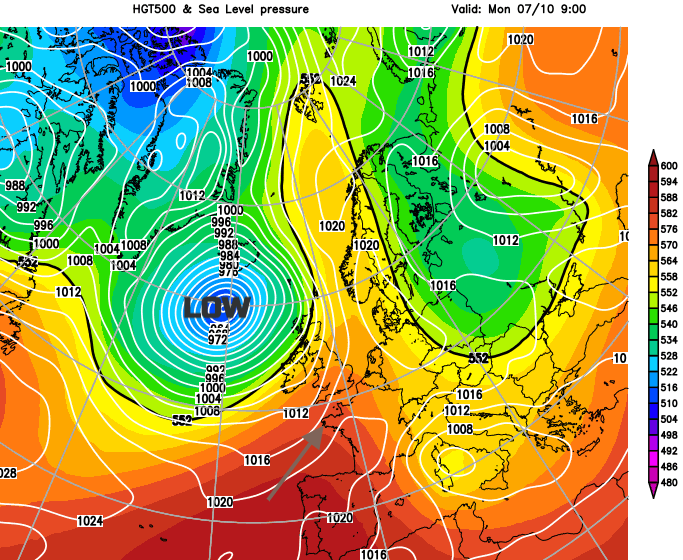
With a deep low away near Iceland there will be brisk winds and bands of rain today. The southeast is a bit more sheltered but this week stays unsettled, cooler by Wednesday and often blustery.
We have more rain today, coming in from the Atlantic. It won’t be as heavy for eastern England, good news after Sunday’s downpours and flooding, but still unwanted for today in areas still soggy from the weekend. Parts of Norfolk saw over 45mm of rain in half a day.
Someone told me on Saturday there was a hurricane was on the way? He was off to play golf, so it was important to him to be up to date with the weather. I pointed out that the ex-hurricane, remnants of Lorenzo had gone through Thursday/Friday and there wasn’t another hurricane in this weekend’s forecast. But no, no he was adamant. I do love that; my chosen profession, years of study, following the forecast all week and someone glances at a tabloid headline and all our work is out of the window.
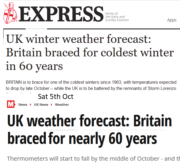
The "worst winter in ** years" alert has sounded in media circles, it is very obvious by now that there is a calendar of “weather events” which are churned through each month. No, we don’t know that the UK is going to have a cold, snowy winter. There is an Upcoming winter speculation and chat - October edition thread in the Netweather forum whilst we await the latest trend forecasts for the months ahead.
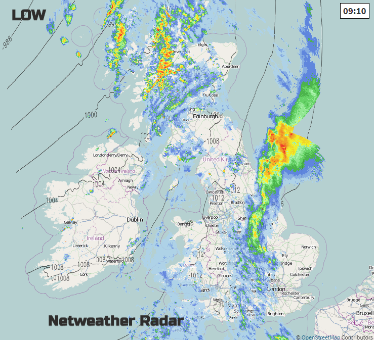
This morning a deep low pressure is spinning towards Iceland and its weather fronts are bringing rain to the UK. There are still flood alerts and a few flood warnings across Britain. There is a lot of cloud about, so a grey Monday morning with a band of rain edging eastwards. It is calm and dry for SE Britain but windy for Scotland, Northern Ireland and western Britain particularly through the Irish Sea and North Channel. Behind the fronts, there are clearer skies, so brightening up for Northern Ireland this morning as the showery rain fades. The winds veer to the SW and with bright even sunny skies temperatures will reach 16C in Belfast. An improving day but breezy.
The strong winds over Scotland are affecting the Monday morning traffic. With gales around the coasts and gusts around 50mph over high ground, it is a windy day with debris already being reported on roads in the north. Spreading across more of Scotland are hefty showers, so more rain blown about in the blustery winds. Western Scotland will see the most rain, but the showers work their way across the country. Temperatures will only reach 12 to 15C and feeling colder in that wind.
For Wales there has already been rain today and the winds will veer to the SW as more cloud and damp weather move in from the west. Temperatures will be around 15 or 16C with strong winds for exposed coasts and hills. Later today the weather will improve, with brighter skies and some drier weather.
After a calm start for SE England and East Anglia a breeze from the south then SW will pickup today. Elsewhere in England there will be moderate to fresh winds, even strong for western coasts this morning. One band of heavier rain if moving over northern England and the East Midlands into the North Sea as more cloud and damp weather follows. The rain turns more showery with blustery winds and temperatures in the mid-teens. Feeling cooler in the wind and rain.
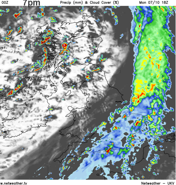
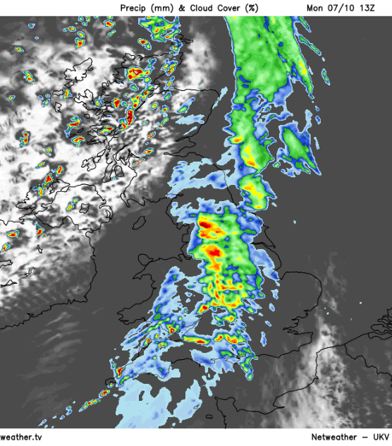
By tonight the main rain bands will have cleared SE Britain, with clearing skies but still a scattering of hefty showers from the NW.
These showers become more widespread on Tuesday, with plenty more rain for the NW Highlands and fresh S to SW winds driving the showers right across the UK. SE England could reach 17 or 18C in sunnier spells but there will be lines of heavy showers heading east and a cooler feel by the end of the day in the brisk westerly wind.
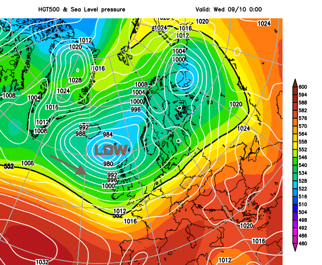
As the low centre drifts closer to northern Scotland in the middle of the week there will be a draw of air from the NW. It stays blustery and Wednesday will feel cooler for everyone and although it will be cool by night, it’s not frosty as the air keeps moving. The week stays unsettled, often blustery with further bands of rain from the Atlantic.