Tuesday's heavy rain included tropical energy from the remnants of Hurricane Humberto. There are several other storms in the Atlantic but only one might influence our UK weather later next week.
As we have seen this week, the autumn weather has become more unsettled with wind and rain across the UK. At this time of year the Atlantic hurricane season peaks and although these storms trouble the Caribbean and USA in their tropical form, the UK often receives the changed remnants later. This can be days, even a week after transitioning to post-tropical low.
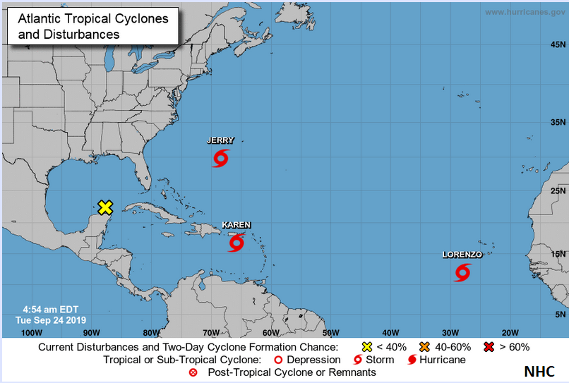
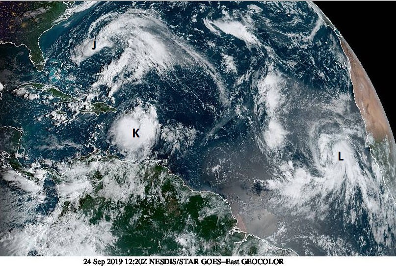
Currently, there are Jerry, Karen and Lorenzo lurking over tropical waters. Tuesday’s heavy, thundery UK rain had links to Hurricane Humberto, its extra energy adding to the mix as an extratropical low pressure moved by midweek. There has been localised flooding and some disruption from the heavy rain. We don’t get hurricanes here in the UK although we can experience hurricane strength (Force 12, 73mph+) temporary gusts occasionally. If an ex-tropical storm reaches our shores, usually the extra humidity and warm air caught up in the atmosphere bring heavy rain, sometimes with embedded thunderstorms, and strong winds to the UK.
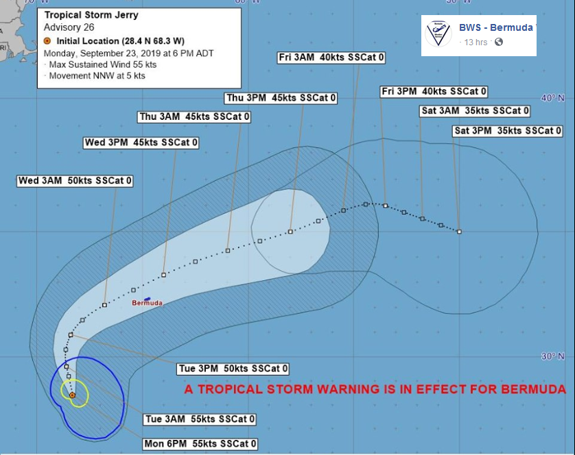
Tropical Storm Jerry
Tropical-storm-force winds are expected on Bermuda later today. Large swells are also expected to affect the coast of Bermuda during the next few days. These swells could cause life-threatening rip currents.NHC
“Jerry is forecast to bring tropical storm-force winds from early morning on Wednesday and extend into the afternoon period.” Bermuda Weather service.
Weakening has begun, … further weakening is expected, and Jerry should degenerate into a remnant low in 4 days, with dissipation occurring over the weekend, and this scenario is consistent with global model forecasts.NHC
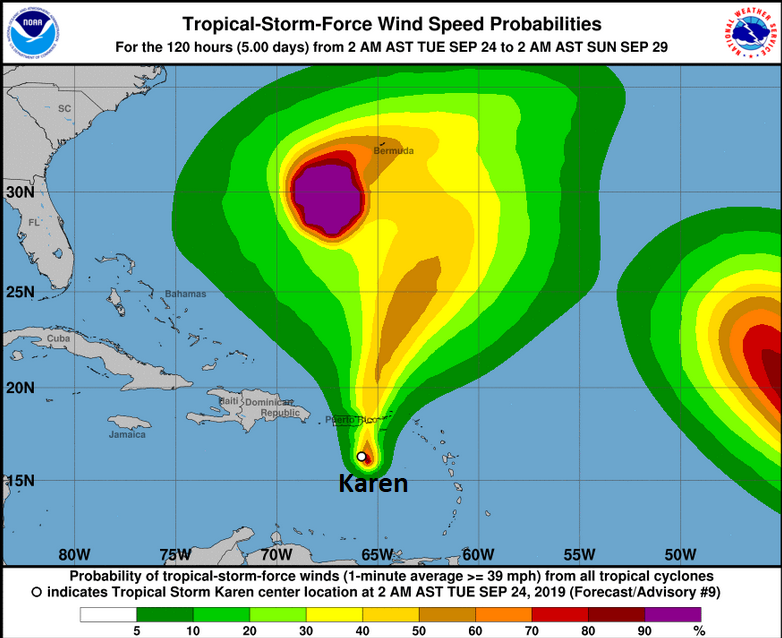
Tropical Storm Karen
There is quite a lot of uncertainty and model disagreement about Karen.
Karen is expected to bring heavy rainfall, flash floods and mudslides to Puerto Rico and the U.S. and British Virgin Islands today, where a tropical storm warning is in effect. The rainfall and potential flooding will likely continue on Wednesday even as the centre of Karen moves away from Puerto Rico and the Virgin Islands. NHC
As a result, the wind cone is large, with a general path northward nearer to Bermuda. Puerto Rico has just had a magnitude 6 earthquake this morning and awaits this tropical storm. Schools and colleges are closed and all, but essential public service workers have been sent home. Karen stays at Tropical Storm status when heading north, on the NHC forecast.
Tropical Storm Lorenzo
This is a much bigger storm. Soon to become a hurricane, then a major hurricane it is further east but still well out at sea, the islands showing nearby are the Cape Verdes
“It is worth noting that all of the global models show Lorenzo becoming a fairly large and powerful hurricane within the next 5 days. NHC”
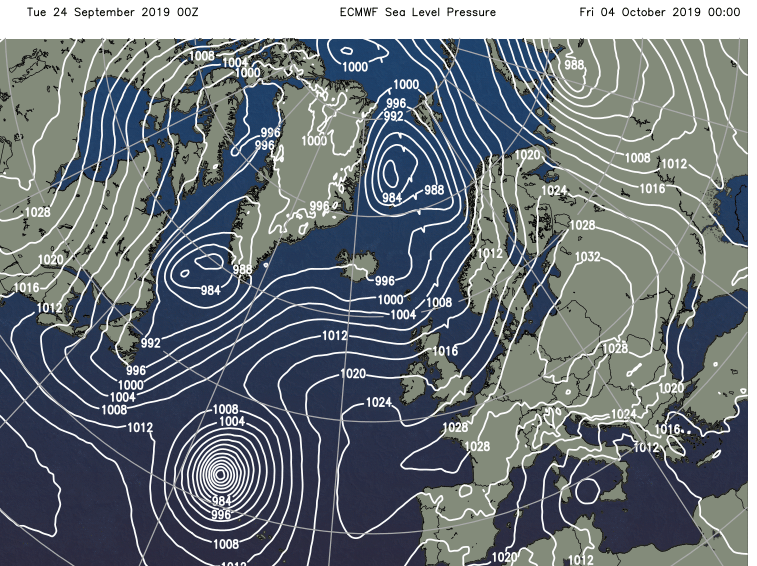
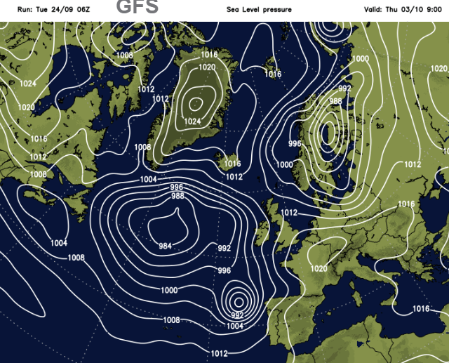
What has caught the eye on charts for next week is Lorenzo’s progress northwards. Below is the ECMWF output and GFS, showing different paths by the 4th, one north the other much closer to NW Spain by the 3rd. So, something to watch as we head into the beginning of October but not to get hysterical about at this stage (headline writers).
Just in case you missed it, there was also Mario. With all these storms to monitor you can imagine that the NHC needed a bit of light relief #GameOver.
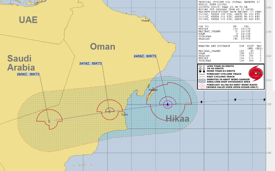
In the Arabian Sea is Tropical Cyclone Hikaa 03A. These are not defined as tropical storms or hurricanes/typhoons but always remain as a TC. Hikaa has strengthened to the equivalent of a Cat.1 hurricane but will weaken as soon as it makes landfall over Oman.
Cyclones are quite unusual in the Arabian Sea but not unheard of.
"The direct effects will be starting today afternoon associated with heavy to very heavy rainfall, the amount ranges between (60 and 100mms) and gale winds ranges between 55 and 65 knots.(75mph Hurricane force). Rough sea state is expected over the coastal areas of South Al-Sharqiya and Al-Wusta with maximum wave height ranging between 4 and 6 meters. Storm surge might cause seawater inundation over low level coastal areas " Oman Meteorology
More discussion and chat about Tropical Storms around the world on the Netweather forum.