After a showery start, high pressure will build into the south from midweek, settling the weather down for many. That fine, warm weather is likely to last into the start of the bank holiday weekend but will it last?
At last, high pressure is set to play more of a role in our weather during the upcoming week, with the southern half of the UK seeing the initial benefits once it arrives. With a bank holiday weekend on the way (south of the border at least), this all sounds like good news, and it may well be, but true to form the forecast isn't looking entirely straight forward.
We'll revisit the bank holiday later on, but for now, it's a familiar picture with the low pressure which turned up on Friday, still with us. It's moving across the north of Scotland today, bringing more showers and still blustery winds.
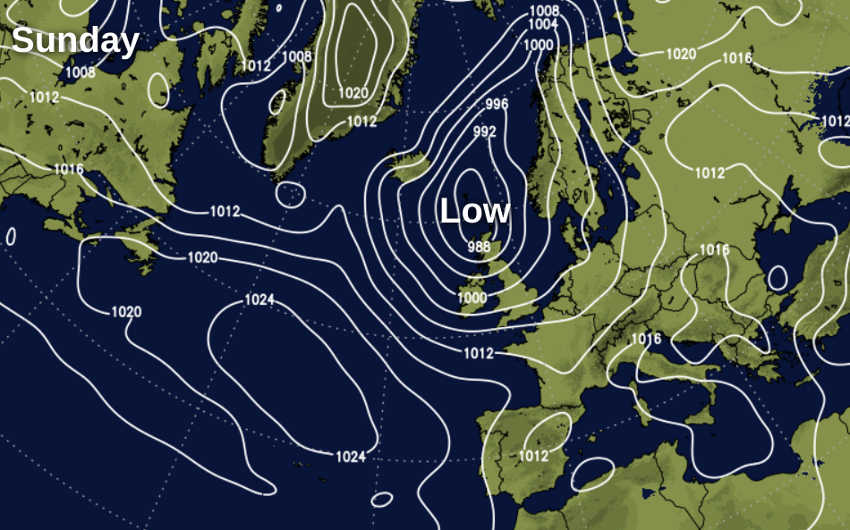
The showers will be most frequent across the north of the UK, moving west to east as they spiral around the low, but nowhere will be sure to miss them. Some are also likely to the thundery - a storm forecast has been issued for today.
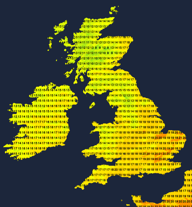
With winds from the west, you'll need some shelter to feel the benefits of the sunnier spells. These'll be most frequent in eastern and central parts, where it'll be warmest with highs of 18-21c in England, 16-18c in Scotland. Further west, 15-18c will be more like it.
Into Monday, our weekend low will still be an influence, despite being a bit further away over the North Sea. Winds will start to ease down through the day, but there'll be a good rash of showers, and with lighter winds, they'll be slower moving than they have been over the last couple of days. Some are liable to be heavy, if not torrential with some thunder and hail in the mix too. Temperatures will be on a par with today (Sunday).
Many of the showers should ease from the southern half of the UK by evening, to leave a sunny end to the day here. But further north, some will continue through into the night.
Tuesday then brings another day of sun and showers, with temperatures very similar to other recent days.
There'll be a couple of changes into midweek. Pressure will be starting to build in the south. But at the same time, low pressure will near further north, throwing a weather front inland, bringing a spell of persistent rain down from the northwest.
Timings are tricky at this stage, but rain will move into Ireland and western Scotland first, heading southeast later. Behind the rain band, there'll be sunny spells and a few showers. The same can be said ahead of it too, where it'll be warmest with highs of 21-23c in southern, central and eastern England.
The front bringing the rain will continue to move southeast into Thursday, but as it runs into the higher pressure, it'll tend to have the life sucked out of it. So, by the time it reaches southern England, it's liable to be just a few showers and some extra cloud. For most other of England and Wales parts of the country, it'll be a mostly dry day with sunny spells and just a scattering of showers in the north.
Another spell of rain will arrive from the west into Scotland and probably Northern Ireland during the day as low pressure moves through between Scotland and Iceland.
Friday and the start of the long weekend follow a pretty typical pattern for the UK, that is a northwest to southeast split. We'll have high pressure further south and east, keeping the weather settled and warm with temperatures heading into the mid-high twenties for many. Further northwest, with low pressure not too far away, it'll be cooler with the threat of some showery rain at times.
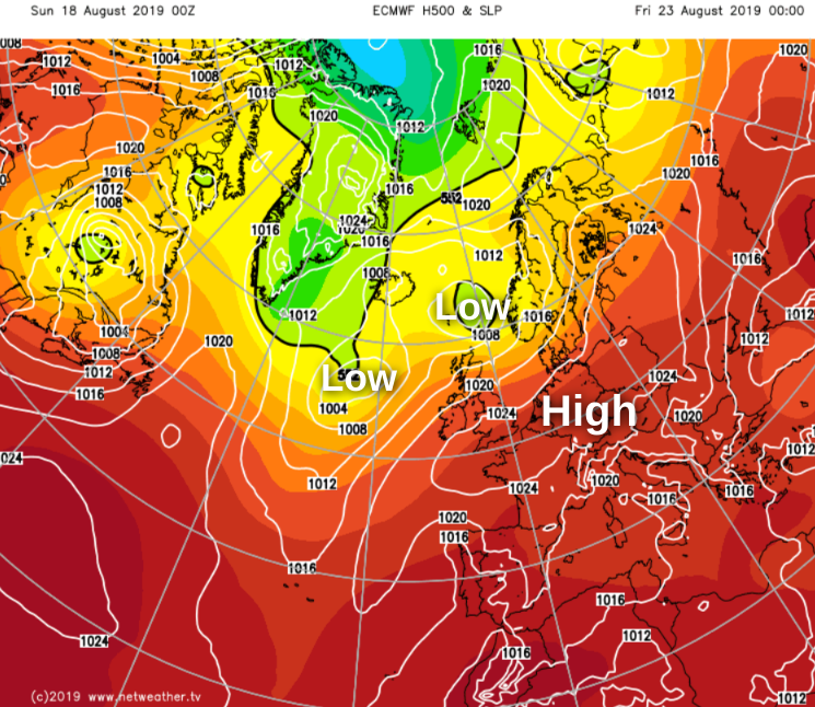
Later in the weekend and into the bank holiday itself, things start to get more complicated. It's all about what an Atlantic low is going to do; most models take it on a pretty typical track close to the north of Scotland on Sunday. But one or two slip it further south, with it ending up not far from the south of England by Monday.
 So, the most likely picture is that Sunday could see some rain sinking further south, but with the main bulk of the unsettled weather staying across the north of the country. In this scenario, the high pressure then quickly builds from the southwest into holiday Monday with most places enjoying a fine day. The other, at this point, less likely option, keeps pressure from building, so Sunday and Monday would see more widespread showers.
It wouldn't be a bank holiday without a forecasting headache, but hopefully, things will become clearer during the next few days.