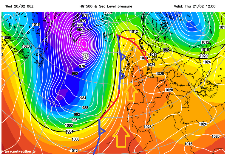
For the highest UK temperatures, those up in the mid to high 30sC, you would be looking at a southerly or southeasterly flow pumping in hot air. The all-time temperature records in the summer are broken after several days of heat, with clear skies and sunshine beating down, heat wave conditions. Residual heat in the ground and buildings remains overnight and temperatures at the beginning of the day already quite high, even before the daytime solar heating gets going.
At other times of the year, surprising locations around the UK get the highest temperature of the day or, away from the summer months, break the monthly record. This can happen in a southerly or southwesterly wind and sometimes in an east or westerly wind.
This is due to a different process which can throw up high temperatures. There has to be a particular set of conditions in place but the basics are: mild, moist air moving up and over high ground on a brisk wind which then dries out ready for its descent on the other side of the hills or mountains, After going through this process, the air on the other side of the high ground, the leeward side, is warmer, sometimes much warmer. And so high temperatures appear to the lee of hills and mountains in places like north Wales, west Wales, NW Highlands, Grampian, or NE England. This is the Foehn or Föhn Effect.
" a downslope wind in the lee of a mountain that is accelerated, warmed, and dried as a result of the orographic disturbance on the prevailing flow." WMO
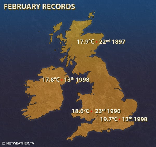
The January UK record; Aber in Gwynedd, north Wales 18.3C. In March for Wales; Prestatyn, north coast 23.9C. December, UK record; Achnashellach, Highland 18.3C.
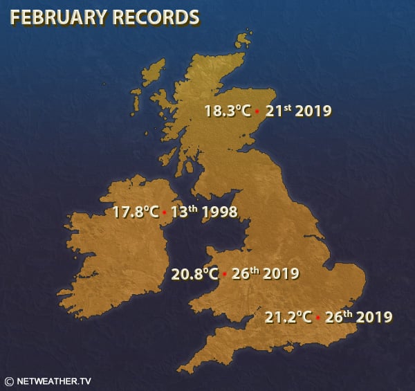
The February records above show Aberdeen to the lee of the Grampians, the Mourne Mountains in Co. Down, the Brecon Beacons in Wales all having an influence to produce the high temperatures.
To start with a mild, stable flow is needed that is humid, so has picked up moisture from the seas it has travelled over. It reaches the UK and as the air is forced upwards, having nowhere else to go thanks to the mountain range, it changes. The air cools with height and the moisture begins to condensate out. Clouds form, it may rain. Latent heat is released during the change of state from water vapour to liquid water. So extra warmth is added to the air heading up the hillside. There can be mechanical overturning and mixing and the less humid air accelerates going down the other side. Sometimes there isn't enough oomph to get the low-level air up and over the mountains but warmer drier air can be drawdown into the mix and helps add to the less humid, warmer moving flow.
Around the world, there are many famous named winds which follow this process- being a warm, dry wind that occurs on the downward slope of mountains when warm air has lost its moisture. The Chinook 'Snow eater' downwind of the Rockies, the Santa Ana in California which has been deadly in combination with the wildfires and the original Foehn named at the European Alps which can bring avalanche risk.
So when Aberdeenshire next beats SE England for the highest daily maximum temperature, it is probably due to the Foehn Effect.
Update from end of Feb 2019, three new records after several record breaking days. Foehn for Aboyne, Aberdeenshire and Trawsgoed then Porthmadog.
Loading recent activity...