A wintry week on the way with Monday and Tuesday seeing a cold front move south bringing strong winds, rain and snow, with a much colder airmass behind it.
If you like your weather to have a bit of action, some heavy rain, high winds, sleet, snow, with changes of airmass then this week is going to be a good one for you. There's plenty happening, with the main event of the week likely to be Monday into Tuesday. As an active, squally cold front moves through from the northwest bringing much colder, Polar Maritime air behind it.
Today though, after a frosty start in the east, it's a bit quieter. We do have a fairly weak weather front moving down from the northwest through Scotland this morning and down into Northern England and Wales later, bringing some patchy rain with it. It's a cold front, so there will be a drop in temperatures behind it - with hill snow along the front with brighter skies and some wintry showers following after.
Ahead of all that, there's still a lot of cloud in the west and north, but further south and east there will be some sunny spells today, and for the majority, it stays dry too. Temperatures will typically range from 4-7c countrywide, but cooling off a touch in the north through the day.
Overnight, the weather front will continue to move southeast, but it'll be really weak by this point, with just a few spots of rain on it. By morning it'll be through the Midlands and into southern England but probably won't reach the southeast before fading entirely.
Under the frontal band, with the extra cloud, temperatures will stay just about above freezing, but even here some frost is possible. Away from it, there'll be a widespread frost with some icy patches.
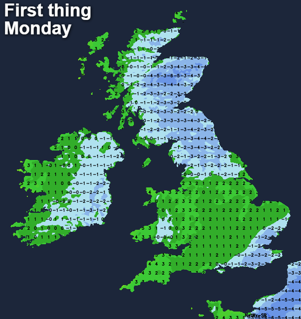
Into Monday, after that chilly start, we'll keep the cloud in southern and central parts for a good portion of the day. Elsewhere it'll be a day of bright, sunny spells and scattered, sometimes wintry showers, with temperatures recovering to a peak of 3-5c typically.
That's only part of the story though, as the next, more active cold front will be starting to move in bringing rain and hill snow with it. Initially into Northern Ireland and western Scotland during the late morning and early afternoon, it'll fairly quickly head further south and east during the second part of the day. It'll become windy too, with gales and some real squalls blowing up as it moves through in particular. With winds starting in the southwest, swinging into the west, then northwest as the front moves through, colder air will quickly tuck in, perhaps turning its trailing edge to snow, and certainly driving a fair few wintry showers in behind it.
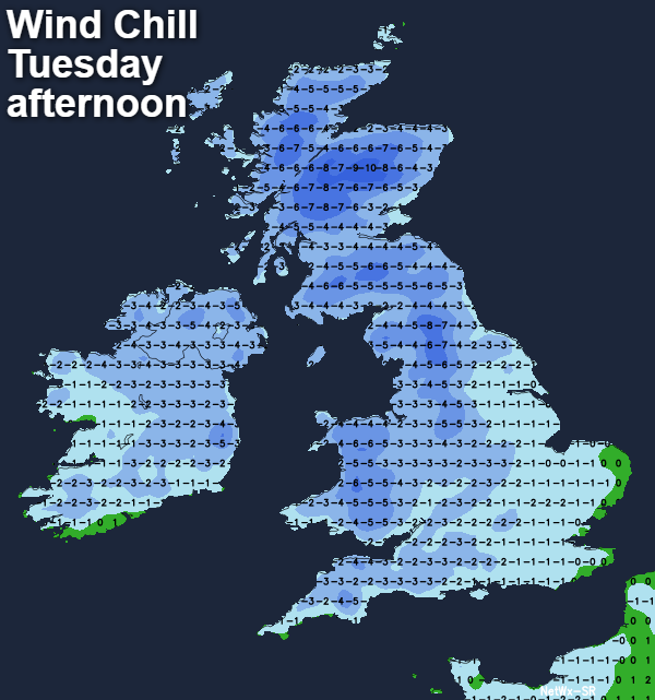
The front will clear the southeast during the first part of Tuesday, then leaving the whole of the UK and Ireland in a cold, unstable Polar Maritime airmass. That's going to mean a good rash of often wintry showers being blown through on a strong northwest wind with sunny spells in between them - especially in the east. It'll be a cold day with highs of 1-4c generally, but if you take the wind into account too, it'll feel sub-zero just about everywhere.
After widespread frost and ice Tuesday night, Wednesday will be another cold day. There'll be fewer showers for many, but still, some blowing onto coasts prone to the northwest wind, and also into northeastern Scotland with low pressure nearby helping to pep them up. Away from the more showery areas, there'll be plenty of winter sunshine, but with temperatures still not far from freezing and feeling even colder in the wind.
There's lots of uncertainty as we move into the latter part of the week. It does look likely that Thursday and Friday will continue with a cold theme in many parts, although some rain and snow may make it into the west and north of the country.