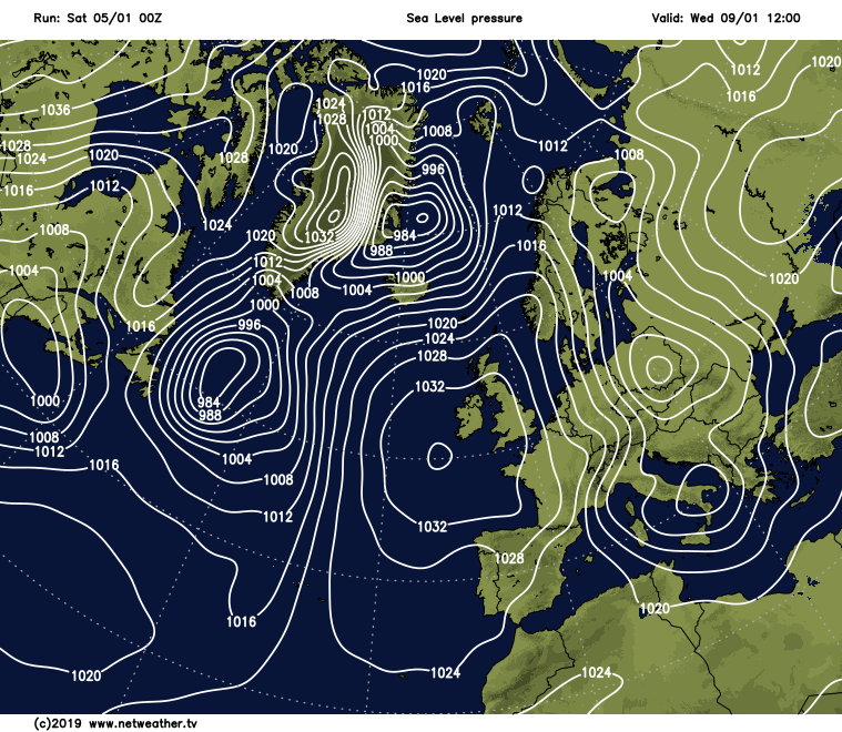
High pressure continues to run the weather show this weekend, but change is on the way as it sinks south and allows low pressure to move in early next week.
High pressure continues to run the show this weekend, but change is on the way as it sinks south and allows low pressure to move in early next week.
The slow change will be apparent as we move through the weekend too, as the high slowly moves south, allowing more moisture over the top of it, making for a cloudier picture than yesterday. By tomorrow, the cloud may even be thick enough to bring some drizzly bits and pieces of rain south during the day.
Another change this weekend will be the temperatures. They're going to continue to struggle today with highs of 3-5c typically, but by tomorrow (Sunday), 5-8c will be more like it, with some parts making it into double-figures. The cloud overnight tonight will also mean that frost is limited to a few patches here and there, where skies can clear for any length of time.
Then, by the end of tomorrow, winds will be increasing in the west and north, as low pressure nears. Overnight and into Monday, gales (perhaps severe) will affect the north and west of Scotland along with parts of Northern Ireland. First, they'll be from the west or southwest, but later Monday and through to Tuesday they'll swing into the north or northwest, where they'll be strongest in northern, eastern Scotland and northeast England.
With that change of wind direction, we'll also see colder air making a return, so after a mild Monday, we'll be back to chillier temperatures from Tuesday, with the wind making for an even colder feel.
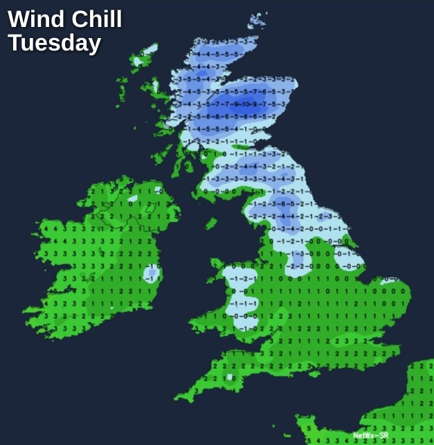
As you may expect with low pressure on the scene, there'll also be some rain around to start the week, working its way northwest to southeast during Monday. Following behind will be sunnier spells and a scattering of showers, which will be turning increasingly wintry from the north as the colder air heads south. They'll be most likely to affect regions exposed to that northerly wind, eventually becoming confined to eastern coasts.
From midweek, high pressure starts to nose in again from the west, eventually killing off any remaining showers in the east.
Cloud amounts will be variable, but there should be some sunshine by day and frost by night. Not too much changes through to the end of the week then, but as the high moves further south, it's likely that less settled, milder weather will begin to move in into the weekend or early the following week.