Heavy, blustery showers will become widespread on Saturday but by Sunday the weather becomes quieter with less showers and lighter winds.
It's very lively at the moment, as Atlantic systems sweep across the country from the West bringing showers and longer spells of rain. There are warnings of severe gales today, with storm force gusts expected in the West and South. Although not feeling so, it's mild over England and Wales, but it'll be turning somewhat colder from the North on Sunday, with showers becoming wintry on Scottish hills.
It's a mainly dry start in many eastern areas with sunny intervals this morning and just a few passing blustery showers, but these are more frequent over Scotland, Northern Ireland and in the West where some are heavy. For most, though it'll end up a day of blustery showers that'll spread to most parts, some perhaps lengthy moving from West to East across England and Wales this afternoon. The North of Scotland will continue to see blustery showers through the day, while southern Scotland although very blustery and showery at first, you may see somewhat of a lull into the afternoon.
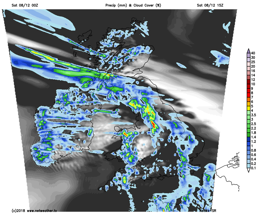
A strong West wind will give storm force gusts in excess of 60mph in the West and South and in exposed areas, with gusts of up to 40 to 45mph in heavier more squally showers, in a very blustery day generally. Although colder in the far North and feeling chilly in the wind it'll be very mild in the South, with maximum temperatures 8 to 10C over Scotland and 11 to 13C across much of England and Wales.
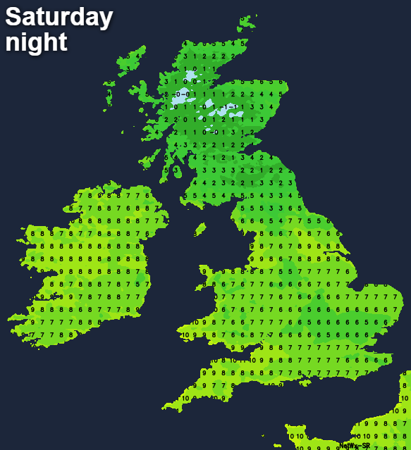
The evening sees further showers over Scotland before it turns colder from the North overnight, leaving just a few showers in the North and East that'll turn wintry on hills. Northern England and perhaps Northern Ireland after further blustery showers should also have become somewhat colder by dawn, as clearer skies spread from the North. Elsewhere there'll continue to be blustery, squally showers in a fresh or strong West or South Westerly wind, that'll gust in excess of 50mph in places. Towards South and West facing coasts and in exposed areas, damaging gusts to 60 even 70mph are likely for a time. Across Scotland and northern England winds will veer North Westerly and ease a little towards morning, but it'll feel increasingly raw, with lowest temperatures here 3 to 5C. Elsewhere although feeling chilly, temperatures shouldn't fall below 7 to 9C.
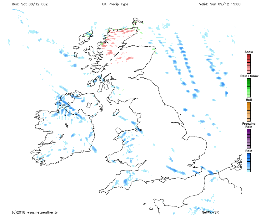
Wales, much of the Midlands and southern England see further showers at first tomorrow, but they'll, but this'll clear to the South. Most parts will then be brighter on Sunday with sunny spells, although Northern Ireland and the West Midlands, in particular, may continue to see a few showers. There'll also be a scattering of showers across the North and East and along exposed coasts of Scotland, some perhaps wintry giving hail, sleet and snow on hills.
Although not as strong and decreasing somewhat further towards dusk away from the North and East, a North Westerly wind will still be blustery in showers. It'll also feel raw in the wind and as a result, temperatures will be down but still on the mild side in the South, reaching 5 to 7C in the North and 8 to 11C in the South.
The North and East and some coastal areas see further blustery showers after dark, with some filtering through the 'Cheshire Gap' into parts of the West Midlands. They'll be wintry over Scotland giving mostly hill snow while elsewhere, they should become isolated. Clear spells allow it to turn cold enough for a slight frost over Scotland and in sheltered rural areas further South, but despite feeling raw, there should be enough of a West to North Westerly wind to largely prevent this elsewhere, with lowest temperatures in the range -1 to +4C.
It becomes quieter into the new working week, a slight frost and patchy fog forming in central and eastern areas for a while overnight. Most models though are suggesting the return of milder, unsettled weather from the West later in the week, but let's just wait and see.