Weather forecasters rely on NWP (Numerical Weather Prediction) models to produce forecasts, but sometimes their output can cast uncertainty - meaning lower confidence, even 5 days ahead.
As weather forecasters trying to predict the weather ahead, sometimes the Numerical Weather Prediction (NWP) models we rely on to make these predictions can throw up a lot uncertainty in timescales greater than only 5 days ahead.
The operational runs of these models are high resolution runs, but often they can chop and change with each run when certain patterns, such as blocking, can cause less certainty, so differences early on can be amplified quickly through the run. This is why forecasters rely on ensembles, so instead of using a single run to get one forecast – which can be misleading, 20 members are run for GFS or 51 in the case of ECMWF run. Multiple ensembles are run, each with a slight variation of its initial conditions and with slightly perturbed weather models. This gives a greater range of possible weather conditions, the smaller the range or spread of these ensembles, the greater the confidence of producing a forecast based on the direction most of the ensembles take.
Yesterday, there were marked differences between model output for next week’s outlook. The graphs of yesterday’s 06z GFS ensembles for sea level pressure showed large spread developing between the 20 members between 00z Tues 27th and 00z Thurs 29th . Each line is a member of the ensembles and where they diverge they show increasing spread. 850mb temperatures, that’s about 1500m up, range from over +10C to -10C by the beginning of December. While sea level pressure between the 27th and 29th of this month showed members ranging between 1030mb and 970mb!
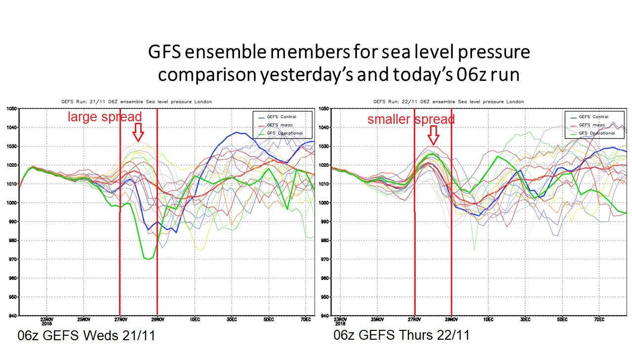
However, today, a forecaster can gain more confidence in the outlook for next week, with GEFS members showing less spread between the 27th and 29th for sea level pressure, with a general trend for pressure to fall towards or below 1000mb, rather then there being a rise in pressure.
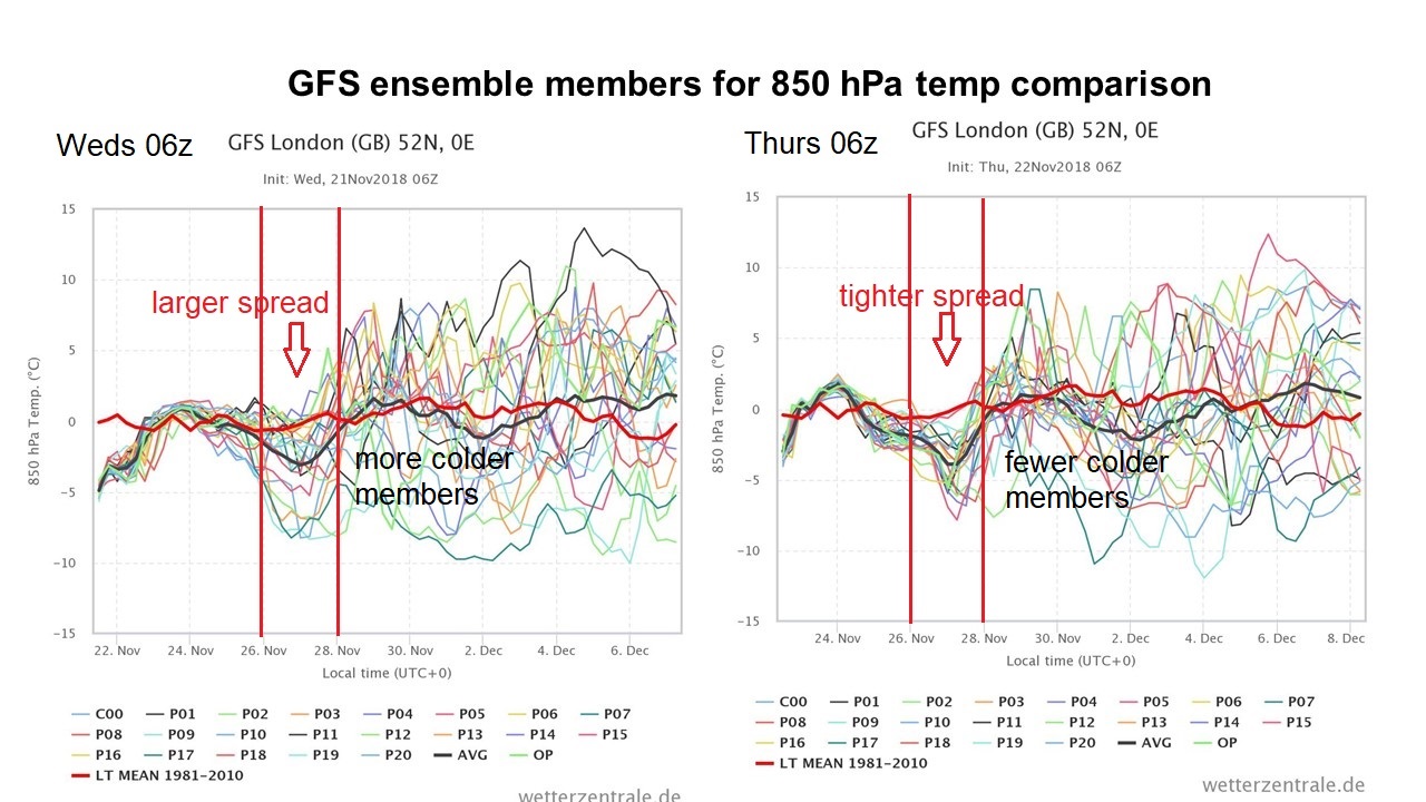
Equally for the 850 hPa temperature, there was a marked spread between the 26th and 28th between all the 06z GEFS members, a tighter spread from today’s 06z run. Also there are fewer cold members on today’s run for later next week (28/11-01/12)
So there is increased confidence now for more unsettled (fall in pressure) but also milder (rise in 850 hPa temp) conditions next week, compared to what yesterday’s model output was suggesting.
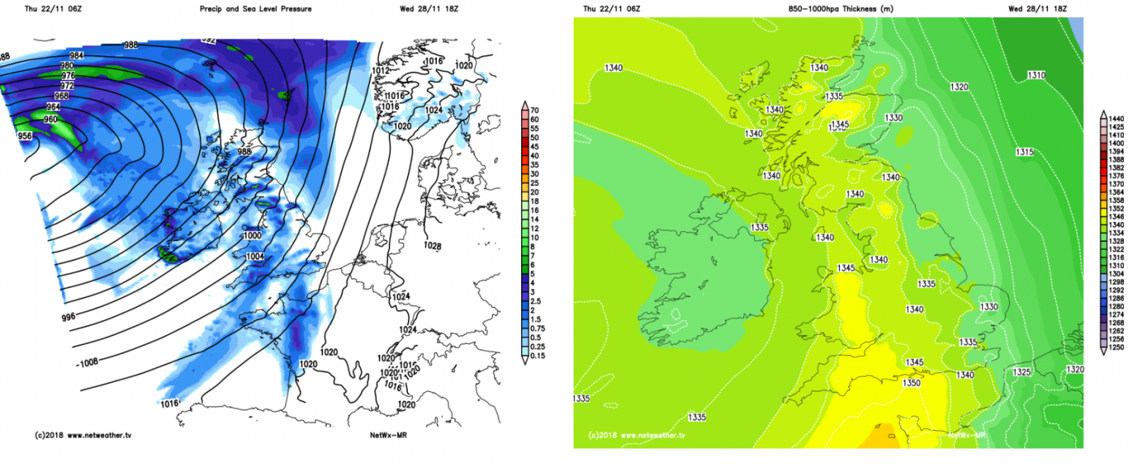
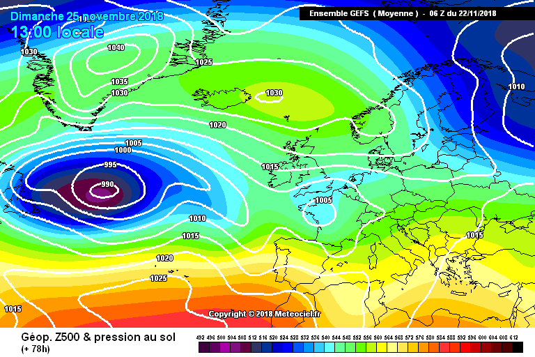
High pressure to the north topples SE into next week, allowing Atlantic low pressure to take control - loop of GEFS mean sea level pressure
However, when there is such large spread between ensemble members of a model run, like yesterday, more sensible forecasters aren’t looking too far ahead with any confidence, so during such times, take any forecasts that potray confidence for what the weather will be beyond 5 days time with a pinch of salt.
At the moment, the upper flow patterns that drive our weather are in a ‘blocked’ state, the weekend past saw the formation of blocking high over Scandinavia, this is forecast to extend west across Iceland and eventually over Greenland by the weekend. From observing and analysing the weather models over many years I have found the NWP models often struggle with energy distribution and trough disruption around these wandering blocking highs, with modelling the movement of these high latitude blocks often fraught with difficulty. Nowhere near as easy for NWP as forecasting detail in a zonal set-up, i.e., lows moving east to west. However, the increased agreement between ensemble members today suggests after a cold start with and easterly flow next week, high pressure close to the north will topple southeastward into eastern Europe as the week progresses, allowing a large low pressure system out in the Atlantic to start moving east to affect the UK with wind and rain along with rising temperatures as winds turn southerly or southwesterly.
Increased confidence now in unsettled and milder conditions from the Atlantic taking over from Wednesday next week