Plenty of fine, bright weather about, away from the far NW. High pressure gives way later this week and cold Arctic air flows in, with windchill, ice and for northern hills, snow showers .
It is going to get much colder this week. We start with a westerly wind and temperatures in the mid to high teens but by the end of this week everywhere will be shivering in an Arctic north to NW wind and stuck in single figures. Quite a change, you may have to adjust your wardrobe but if you are on half term October holidays this week there will be a lot of dry, fair weather about.
This is thanks to a lurking high pressure settling our UK weather down. At the edges of the high, it will still be windy and there will be bands of rain in the far NW, but overall this week is looking fine and bright.

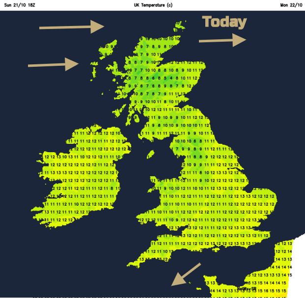
Yesterday’s cold front has taken it’s cold away SE over the English Channel. Behind that are clear skies and it is a cool start for many. There will be lots of sunshine about today, although more cloud for Scotland. Northern Ireland and NW England will also see some cloud about today. In the far north, warm fronts whizz past, pushed by strong to gale force westerly winds. There will be showery outbreaks this morning for the Western Isles, but the Northern Isles become wet today and that will last through tonight.
It stays windy across the northern half of the UK tonight with a fresh to strong west wind. Further south, it will be calm and cool with frost for southern counties of Britain.
Tuesday will warm up. It stays windy over Scotland and everywhere will be breezy but temperatures in the southeast could reach 17 or 18C and eastern England should fair well too. Most places will be fine with sunny spells but always a bit more cloud for western shores. It will be wet again in the far north of Scotland and western Scotland with low cloud and rain. Very wet in the far NW of mainland Scotland. Northern Ireland and Wales look fine.

The middle of the week is fine for most of the UK, nippy by night.

Then a cold front appears on Thursday. This stumbles over Scotland, Northern Ireland and fades over northern England on Thursday night. The winds veer to the NW and colder air begins to move in. The following showers will begin to turn to snow over the tops of the Scottish mountains on Friday. By Friday afternoon it will feel noticeable colder everywhere.
For Friday evening, there could be sleet and snow inland for northern Scotland and with strong north winds, any reduction in visibility won’t help on the roads.
Friday night will be cold with a chilly wind. If you were considering camping or hill walking next weekend, do bear this change in the weather in mind. As bands of showers get pushed southwards there could be sleet or hail for the hills of England and Wales, a bit of snow over the mountain tops even and ice to watch out for too.

Saturday will feel cold with a fresh to strong north or northwest wind. Wrap up if you are heading out. The risk of sleet and snow continues for parts of northern Scotland and rain or hail showers flow down the east coast of Britain and in the west into Northern Ireland and down through the Irish Sea. Inland it’s cold and bright.
Awaiting snow? Netweather community forum Will it snow?