


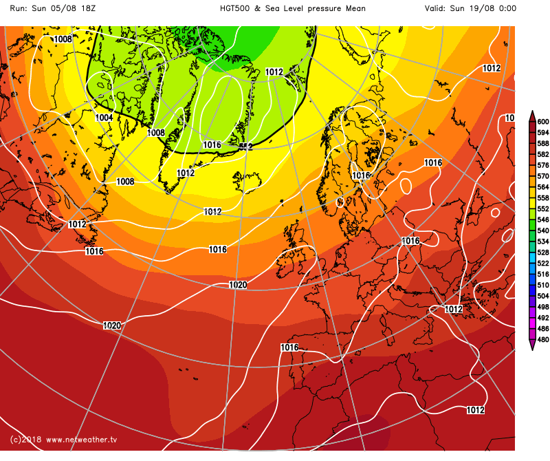
The jet stream is moving south this week, so a change to cooler, less settled weather is on the way.
Time is ticking for the current heatwave, as the cooler weather which the northwest has kept virtually throughout, will start to spread southeast over the next couple of days. The change in temperature will also bring a change in weather type, with low pressure playing more of a role in our weather, as the jet stream heads further south than we've been used to of late.
The heat will still be with us a little while longer though, hanging about in the southeast for longest - up until the end of tomorrow. The same can be said about the settled weather too, with sunshine and showers the common weather type once the cooler weather has arrived. That is, ahead of a spell of wet and windy weather which looks set to visit for the start of the weekend.
Maybe not.. Although this less settled cooler spell is likely to last a week or more, there are some hints that after mid-month, high pressure may well build back in across the country, to allow another more settled and warm spell, with the potential for more hot weather - especially in the south and east. The GEFS Ensembles are one of the models suggesting this may happen, but it's a long way off, and there are no guarantees at this point.
For now though, change is underway already with a band of increasingly showery rain slowly edging south through southern Scotland this morning, getting into the north of England later. Any rain on it, will tend to be mainly in the west, and eventually, it'll become little more than a band of cloud - but it is the dividing line between the cooler air north of and the still very warm and hot air further south.
For much of Scotland today, there'll be some brighter, sunny spells - especially in the east, but also some showers in the west. Temperatures will be warmest in eastern parts, with highs into the low-mid twenties. Elsewhere, northern England will have a lot of cloud, with the best breaks in the east. There'll be some low cloud heading inland into other parts of western England and Wales at times too, but otherwise, there's plenty of sunshine. Temperatures will peak into the low-thirties in the southeast and East Anglia, mid-high twenties in many other parts, but cooler in those cloudier regions.
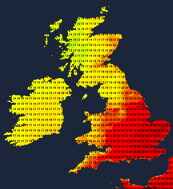
Overnight, the front bringing the change carries on heading southeast, delivering nothing more than extra cloud with it at this point, but there'll still be some showers ongoing in the northwest. That leaves just the southeast quarter of the country with the real heat tomorrow, with highs once again into the low-thirties. Other parts will see some good sunny spells, but with a fresher feel. There'll be some showers, these chiefly affecting the north and west. There is also the outside risk of some thunderstorms developing in the southeast later in the day.
Wednesday onwards everywhere is into that cooler air. The southeast corner will still be warmest, but where highs were into the low-thirties early in the week, they'll peak into the low-mid twenties. Elsewhere, teens to low-twenties will be typical. There will be showers around, these mostly in the west, but the some transferring further east, between them, there'll be sunny spells, so not a washout by any means.
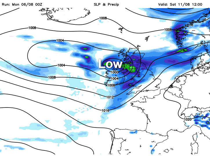
Not too much changes until the end of the week and the start of the weekend, but at that point, a deep low pressure looks set to swing in from the Atlantic, bringing with it a spell of rain and wind.


