Heat peaks during the next two days, ahead of a cooler, fresher weekend.
A change is on the way as we head into the weekend, as cooler and fresher conditions move in off the Atlantic across all parts, but before then it’s set to turn even hotter today and tomorrow, when we could see the hottest temperatures of the summer so far, with 35 or 36C on the cards, or even 37C possible on Friday across SE Britain, which will challenge the July all-time top temperature record of 36.7C recorded at Heathrow on the 1st July 2015 and we may even approach the all-time highest temperature record of 38.5C set on 10th August 2003 at Faversham in Kent, but less chance of this. The very warm or hot conditions widespread across the UK too, thanks to a deep southerly flow, into the high twenties as far north as the central belt of Scotland. However, we are likely to see thunderstorms develop later today, overnight and through tomorrow, ahead of a cold front pushing in from the west, which will bring the relief of lower temperatures and less humidity over the weekend for all.
The heat is on the way out by Saturday
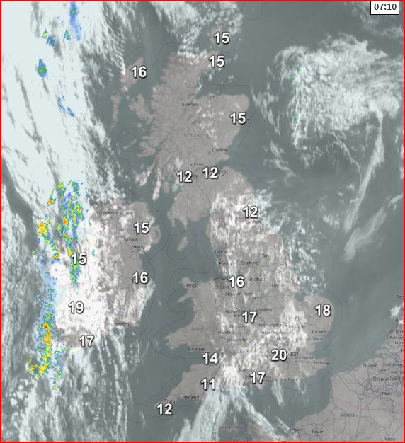
Last night was another very warm and sticky one, not easy for sleeping, with temperatures falling now lower than high teens and even low twenties in the south, already 20-21C at 6am in the London area.
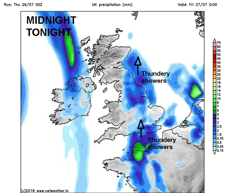
So after a mostly clear night with light winds, we start the day with sunny skies, though with some mid to high-level cloud making it hazy in places, for most it will stay fine with plenty of sunshine through today. Mid-level cloud will bubble up across central and eastern areas to bring a threat of a few thundery showers this afternoon though, but they will be very hit-and-miss, with most in the areas escaping them and staying dry and sunny. Also, a cold front moving across the far west will bring cloud rolling in with showery bursts of rain across Ireland and N. Ireland by late afternoon.
Very warm for many, locally hot across England, very hot towards SE England and East Anglia. Temperatures reaching 27C in Glasgow, Edinburgh and Newcastle, 28C in Cardiff, 29C in Manchester, 32C in Norwich and perhaps as high as 34C in London. Somewhat cooler around western coasts of mainland Britain and across Ireland/N. Ireland – where there will be a brisk breeze.
So a very warm, muggy and thus uncomfortable night for sleeping to come tonight. Some scattered heavy showers and thunderstorms possible across eastern England in the evening for a time before clearing north across NE England and perhaps affecting eastern Scotland overnight. Then a risk of more thundery downpours spreading up from the south overnight across central southern and parts of SE England, The east Midlands, Lincolnshire and then NE England by dawn. Further west, a band of cloud and showery rain clearing Ireland and N. Ireland early in the night before moving east across the Irish Sea to affect western Scotland, west Wales and Cornwall by the end of the night. Elsewhere dry with clear spells.
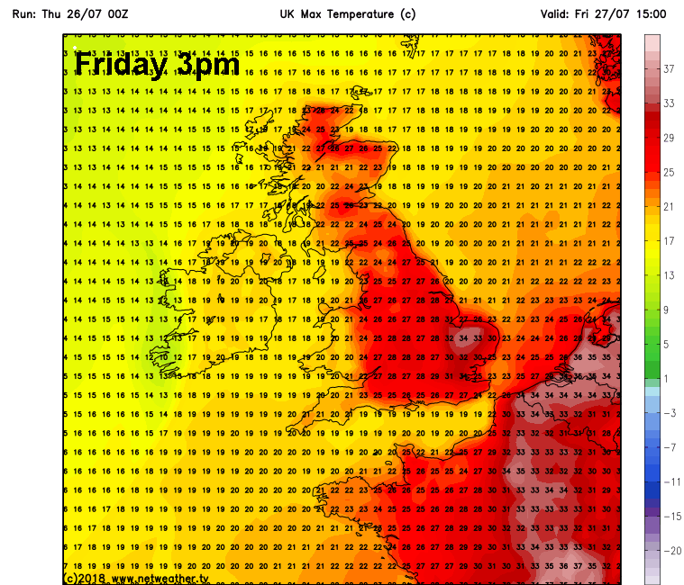
Fresher conditions moving in across the far west behind a cold front moving in across western Scotland, Wales and SW England during the morning and rest of Scotland and western England through the afternoon, bringing a band of cloud and showery rain east. To the east hot and humid with sunny spells developing in wake of early morning thundery downpours clearing north from central and eastern England, extremely hot conditions developing across SE England and East Anglia. We could see temperatures reach 30C in Hull, 34-35C in Norwich and towards the London area, perhaps 36-37C not ruled out somewhere in SE Britain.
Add a few degrees to these usually conservative highs from GFS, could see 36 or even 37C somewhere over East Anglia and towards London
This heat and humidity combined with air cooling aloft with the approach of upper trough to the west and sea breeze convergence inland could trigger some severe thunderstorms across eastern England spreading up across NE England - capable of large hail, strong wind gusts and torrential rain leading to flash flooding. Very hard to predict where exactly these may form and pass over, but they will be hit-and-miss, with some places staying dry.
An novel concept, but maybe worth taking a brolly tomorrow
The cold front reaches the eastern side of Britain Friday night, with thunderstorms, perhaps severe locally, rumbling away north across eastern England and eastern Scotland for a time into the night, before the cold front clearing the east coast Saturday morning eventually clears them out.
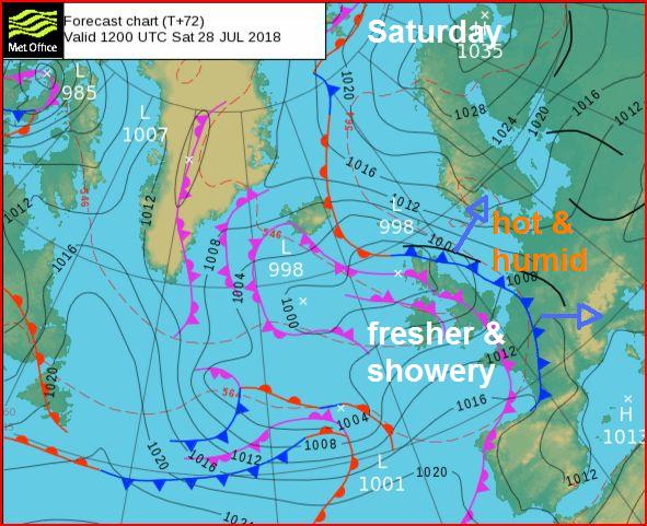
Fresher, cooler and breezier conditions from the Atlantic following across all parts on Saturday, temperatures back to normal for the time of year, cloudier for northern and western parts, with some showery rain at times, drier and warmer towards the southeast. A cloudy day generally on Sunday and cool day across northern and western with some patchy rain spreading in from the west, perhaps mostly dry and bright in the southeast.