The southeast will struggle to get rid of the cloud and dampness this weekend. Elsewhere improving with bright or sunny spells, a few showers but more of a nip in the air on Sunday.
There will be a risk of frost this weekend, so gardeners beware. Also, the cold air hasn’t finished with us yet, here in the UK. For the end of the month, through Easter weekend and possibly until mid-April it will be on the cold side with temperatures below average.
If you are in a sheltered sunny spot, it can still seem pleasant enough but in the shade, rain or wind the chill will continue. It’s quite a mixed picture this morning over the UK. There is sunshine for Scotland and Northern Ireland and bright spells for bits of NW England.
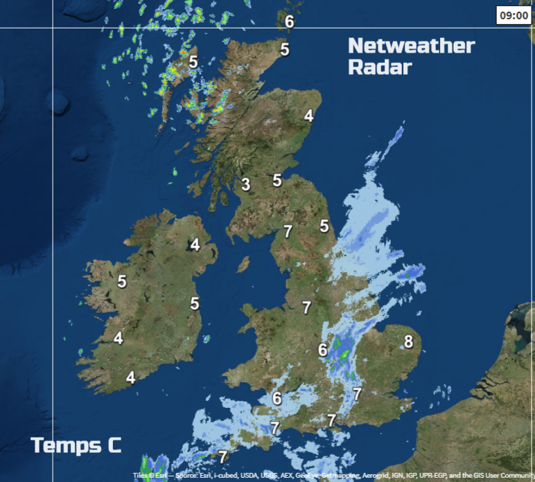
Low pressure heading for the Bay of Biscay has brought more cloud over much of England and Wales and outbreaks of rain this morning. With light winds, just from the NE temperatures will rise to 10 or 11C. A brisk SW wind will pick up for northwest Scotland and push a scattering of showers in which will reach Counties Derry, Tyrone and Fermanagh but overall the fine weather remains in the northern half of the UK. Outbreaks of rain continue for England and Wales with more cloud, but the far SE looks drier and NW Wales and Merseyside with the whole damp, grey area drifting SE’wards later in the day
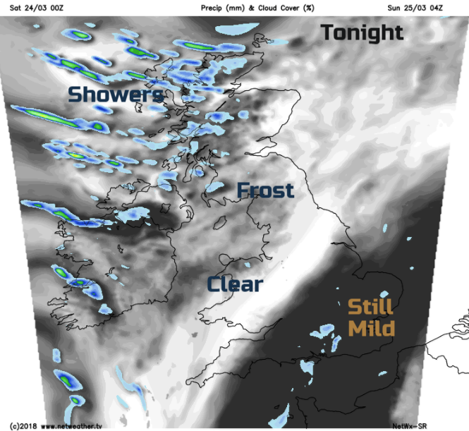
SE Britain stays mild underneath the cloud cover but elsewhere will be clear and cool with frost in places. The showers continue to feed in from the NW and will be wintry over the Scottish mountains.
By Sunday pressure is rising from the SW as cooler air moves over the UK. There will be a light to moderate wind over the UK a good deal of bright fair weather and just a few showers. The SE of England will still have more cloud and dampness in the air, a trailing front really is reluctant to clear.
A chill to start Monday but overall a fine day. Then we are looking to the Atlantic as a weather system heads our way for Monday night. There will be several cms snow over the hills of Scotland, maybe a bit to lower levels north of the central Belt just for a time before the rain takes over. Tuesday will be wet and windy with milder air arriving from the SW. Once the warm front rain is through, temperatures will leap up to 14 maybe 15C in parts of England. The cold front follows on Tuesday and then things change.
By Wednesday in a NW wind, it will feel colder and with an unsettled mid-week there will be more rain, with sleet and hail. A front could stagnate over NE Scotland and bring more snow midweek even to lower levels. It looks windy, with spells of rain from the south, turning wintry against the cold air, more frosts. It doesn’t look great in the run up to Good Friday if you were hoping for a pleasant outdoor holiday weekend. It looks especially cold for NE Scotland and the Northern Isles by the end of next week.
After the SSW event earlier in the year, it can take months for the atmosphere to recover and with high pressure showing signs of building once more over Scandinavia, there will be more chance of a northerly or easterly flow taking hold over the Easter holidays. With colder air over more of the UK, there is still the chance of snow showers, where and when will have to wait until nearer the time.
Clocks change tonight - Why?