


Heavy rain has caused flooding for Ireland and SW Britain. This rain is heading NE and as cold air approaches, there will be snow, ice, hard frosts and bitter cold through the weekend. Brrrrr!
Across the UK this morning there is mild air in the SW with temperatures around 8 or 9C, and for the NE, it is cooler at only 4 or 5C. We have high pressure over Scandinavia and a large area of low pressure off W. Ireland. In-between brisk flow from the SE and weather fronts which have already brought plenty of rain and even flooding in places.
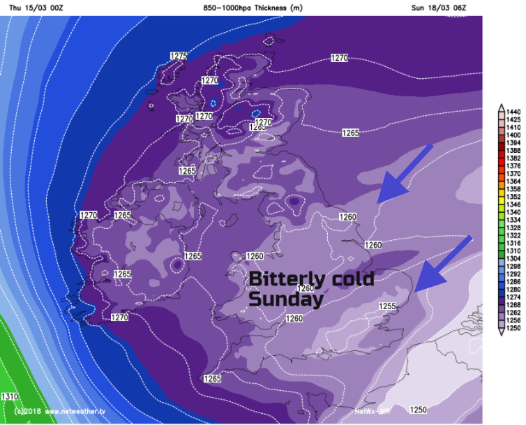
Through the end of the week, our weather action comes once more from the east and it will be cold. After the midweek rain, much colder air will approach across the North Sea making its presence felt this weekend. And there will be snow showers for some.
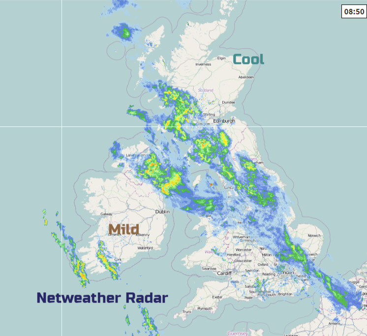
This morning the rain is continuing over Northern Ireland where a Met Office yellow warning continues until lunchtime. Several roads are closed due to flooding and the band of rain will continue for the next few hours as it clears northwards by lunchtime. It will remain windy through the North Channel this morning before the milder air reaches Northern Ireland and temperatures rise to 10 or 11C and the winds ease off. Much improved this afternoon.
The bands of rain move NE across Britain today, so away from the SW where it has also been wet. The rain moves north through Wales, continues for the Isle of Man, SW Scotland, over more of northern England and into East Anglia with more patchy outbreaks for SE England. Ahead of the frontal rain, strong SE winds continue for Scotland and NE England with lee gusts over 70mph and severe gales in the far north. The rain bands move up into central and SE Scotland this afternoon. Showery bits follow, with another line of blustery heavy showers into Cornwall later today. The winds ease off for England and Wales as temperatures rise into double figures on another mild day.
It stays cooler for NE Britain especially feeling that way in the wind. There will be snowfall over the Grampian mountains and then we await the truly cold air.
Friday
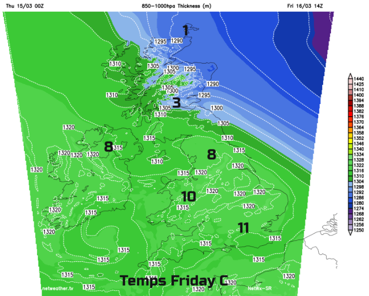
It stays windy for Scotland and NE England on Friday with air temperatures of only 4C, feeling cold along the North Sea coasts. Other parts of the UK should reach 9 or 10C as further showery bands march northwards. There will be bright spells then hefty downpours with longer spells of rain for Wales across to eastern Northern Ireland.
Though Friday night the cold easterly flow takes hold of the UK. Temperatures plummet and it will feel different, noticeably colder with an intense chill. The snow level will fall over NE Scotland during Friday pm and overnight snow showers affect eastern Scotland and NE England across to the Pennines. There is a yellow warning for Snow & Ice with a few cms forecast for North York Moors, the eastern Pennines and Cheviots into Saturday morning. Cloud and precipitation which has been progressing NE for the end of the working week then retreats SE. There is another yellow warning over eastern England as the rain band begins to turn to snow and widespread ice could cause problems for Saturday morning.
Skies clear and it will look fine and bright on Saturday. Pockets of snow showers will appear for eastern Britain, but confidence is still low about where and how much will lie.
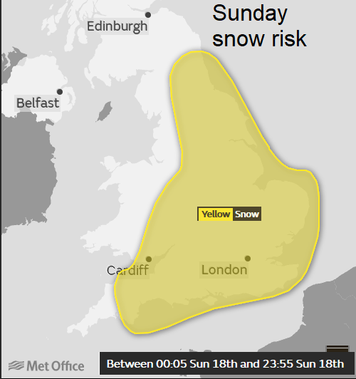
Overnight into Sunday, there is a signal that snow of more likely across parts of SE Britain. There is a Yellow Be Aware warning for Snow
…air crosses the North Sea snow showers will form on Sunday and could well merge into convergence lines producing 2-5 cms of snow in places. This is most likely near the Thames estuary and the Wash, and these snow showers could then spread westwards.
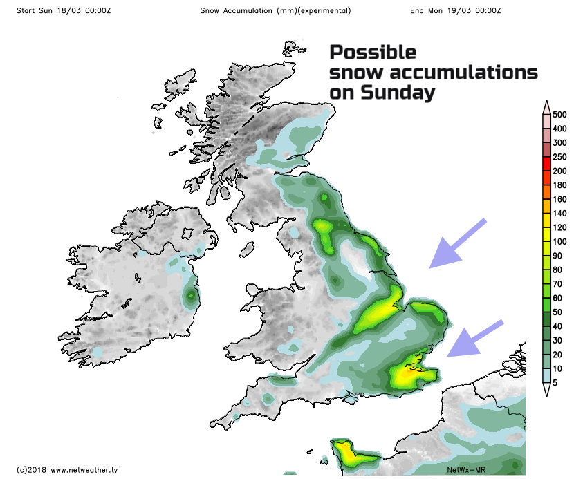
In these situations, the snow shower line up depending on the wind direction and a certain area can get a few cms, yet not too far away, barely anything. The fresh to strong NE Wind will chill you as daytime temperatures struggle above zero. Western areas will be more sheltered and see +4C.
By Monday and Tuesday high pressure will have moved over the UK, so winds will be lighter, the weather more settled. Sunshine amounts will vary as low cloud pulls in from the east. If you do get any snow, the sun will work on it quickly, not like last time. There are still lumps lingering at roadside from where it was cleared earlier in March when the Beast from the East came.
The wind will be brisk of SE Britain from the NE then north, so this will add to the chill and there will be widespread severe frosts, Gardeners take note. This weekend cold is unusual for this time in March and will be a shock after the recent hints of spring. Please don’t underestimate how cold the air will feel if you are out and about Friday night through until Monday.


