
Colder, windy and showery today and tomorrow, showers falling as sleet and snow in the north.
After a mild start to the week, winter’s back, in the north at least, with sleet and snow showers across Scotland and Northern Ireland overnight giving a covering in places and there are showers elsewhere. Wednesday and Thursday will continue the colder and showery theme and windy too, most of the showers in the north and west, wintry in the north, where snow will fall to lower levels. Friday’s looking mostly dry after a frosty start, then turning briefly milder overnight into Saturday, as cloud and rain spread in from the west across all areas, before colder and clearer conditions return from the northwest later in the day and through Sunday. Perhaps turning even colder early next week, as very cold continental air from the east moves in.
For now, a strong westerly wind continues to blow in showers across many areas, behind a band of rain along a cold front clearing southeast England, it’s mild south of northern England, so showers are falling as rain, but across northern England they are falling as snow over higher ground, while across Scotland and Northern Ireland they are falling as snow to lower levels. With temperatures close to freezing across inland parts of Scotland and Northern Ireland, there is a risk of ice where snow is settling, with some treacherous driving conditions likely over higher routes where snow may bring 2-5cm. The Met Office have weather warnings in place for Scotland and Northern Ireland for snow and ice.
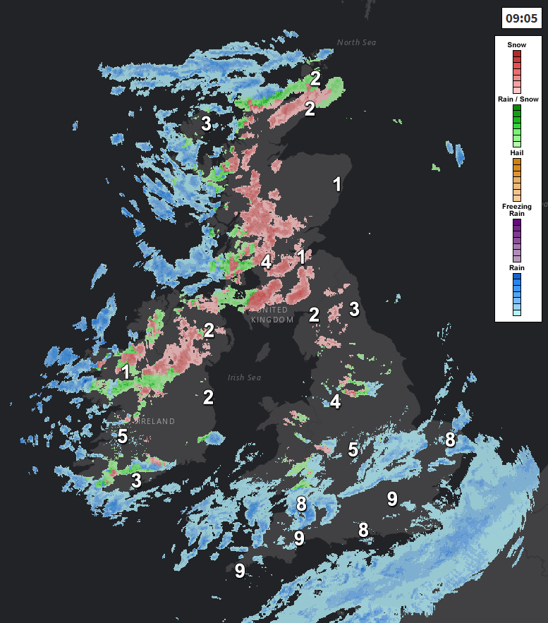
Sleet and snow showers will continue to feed in for much of the day across Scotland and Northern Ireland on a brisk westerly or northwesterly wind, snow settling mostly over higher ground, but snow falling to lower levels too at times inland with some hail likely mixed in towards western coasts. However, much of eastern Scotland could escape with a mostly dry and sunny day with shelter from the westerly wind. Further south, showers will move through across many areas, locally heavy, with some brightness in between. Showers most trequent across SW England, Wales and northern England, falling as rain, sleet and hail at lower levels, snow over the hill tops in the north and northwest.
The strong and cold wind will making it feel closer to freezing, despite screen temperatures reaching 6-8C in the south, feeling like below freezing in the wind in the north, air temperatures reaching 3-5C here.
Strong wind veering northwesterly to northerly in the north tonight and continuing to feed in wintry showers across Scotland, Northern Ireland and northern England, bringing a risk of snow and ice on roads overnight, particularly over higher ground. Some rain, sleet and hail showers affecting Wales and SW England, drier further east across England.
Watch out for the super bluemoon tonight if you have clear skies, more on this in my latest blog
Thursday isn’t looking any warmer, with low pressure moving into the North Sea allowing a cold northerly flow across the British Isles, which will bring further wintry showers to northern Scotland and down across western coastal counties, but for many central and eastern areas of England and Scotland it will be a dry and sunny day. Temperatures reaching 5-7C generally, but feeling colder than this in the strong wind.
.png)
Showers easing Thursday evening, skies clearing and the wind easing overnight, which will lead to a widespread frosty start to Friday, which will be a mostly dry and sunny day with light winds, just a few isolated showers around eastern coasts. Clouding over with rain arriving towards the northwest in the evening.
Cloud and outbreaks of rain spreading east Friday night, reaching the east by daybreak on Saturday morning, briefly milder across the south and the cloud and rain perhaps slow to clear the east during the day, but as the rain clears western areas and skies brighten, it will turn colder as a northwesterly wind sets in, which will bring showers too, which will turn increasingly wintry in nature.
Sunday’s looking chilly, perhaps dull and damp across England, with some wintriness falling in places as a raw northeast wind develops. West Wales, N. Ireland and Scotland looking mostly dry and bright or sunny but chilly.
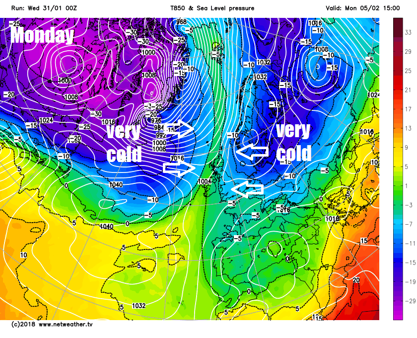
Feeling raw across England and Wales early next week, in a biting northeasterly wind, which may bring thicker cloud and some wintry showers to eastern coasts of England. Bright and dry in the north and west Monday, but Tuesday may see an Atlantic frontal system move in, which may bring snow to northern and western areas – as it bumps into the cold air.


