Spells of cloud and rain queue up, ready to run across the UK with strong winds. In-between, warm sunshine and rising temperatures with one chilly night.
This week will see spells of wind and rain but also mild air, as it gets warmer to end the week.
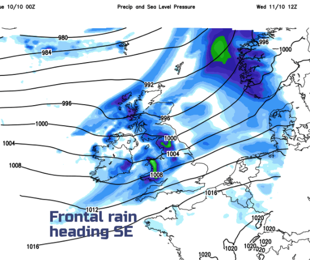
Weather fronts have brought a lot of cloud, drizzle and patchy rain across the UK overnight. There are breaks and brighter skies as the fronts push SE. Things improve through the morning with a fine lunchtime for many in a brief ridge of high pressure. However, another area of low pressure is whizzing in, heading to the SE of Iceland and will bring wind and rain later today.
WInds
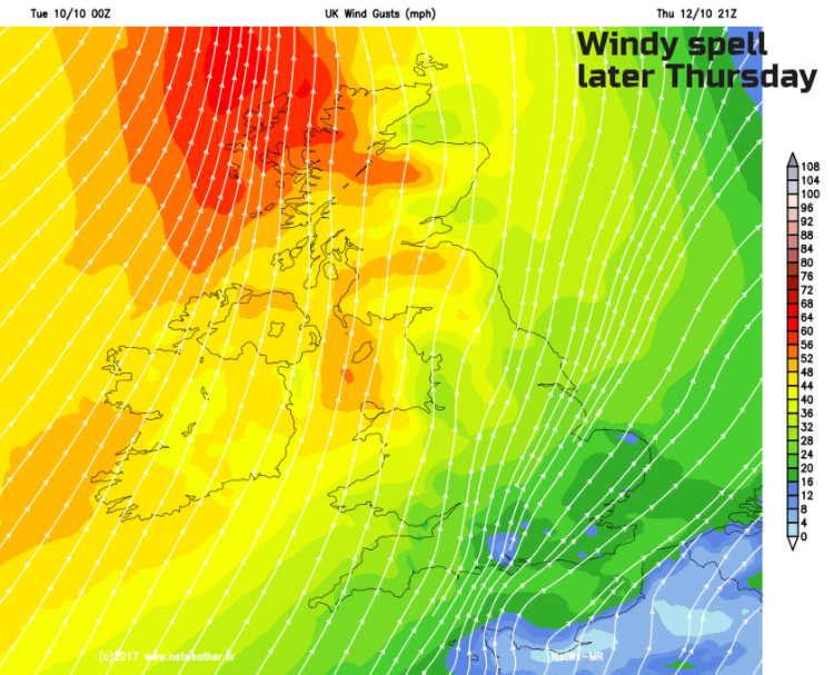
We are in for several windy bouts this week. Tuesday evening for NW UK with gusts over 60mph for the Western Isles. Strong winds and coastal gales will affect Scotland and N.Ireland, then the Irish Sea and northern England by the early hours. There could still be strong gusty winds for Pennine routes for Wednesday morning, also north Wales and the Peak District. Another weather system will bring strong winds and gales to Ireland and then western Scotland for Thursday evening. These winds spill over more of Britain overnight quite quickly but again there could be tricky driving conditions on higher routes with gusts over 60mph and possibly stronger winds for Shetland into Friday.
Rain
Western Scotland is going to see a lot of rain this week. Weather fronts just keep on heading in, dumping their rain as the air lifts over the Highlands. The rain starts this afternoon with damp weather brushing Northern Ireland and reaching northern and NE Scotland. Tonight the band will spread over more of N.Ireland and Scotland into northern England and Wales.
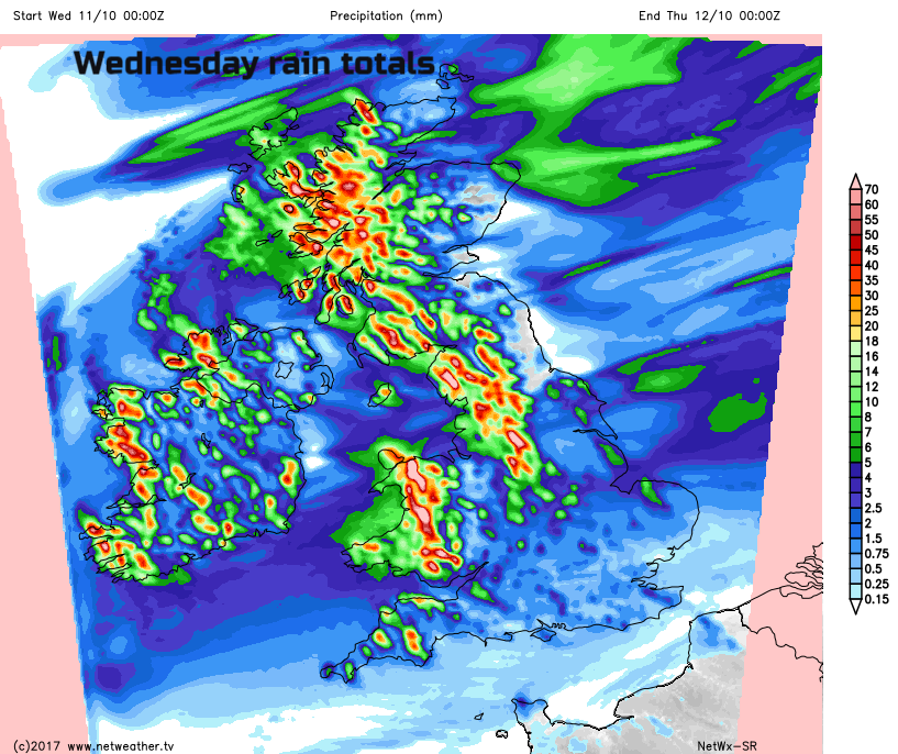
By Wednesday the main area of rain should be over NW England and north & west Wales, with a pretty miserable start to the day. Low cloud, poor visibility and spray on the roads. Behind the front, it will be brighter and the grey, wet conditions will move over more of Wales and the Midlands, petering out by the evening when it should reach SE Britain. This leaves clear skies for Weds night.
Temperatures
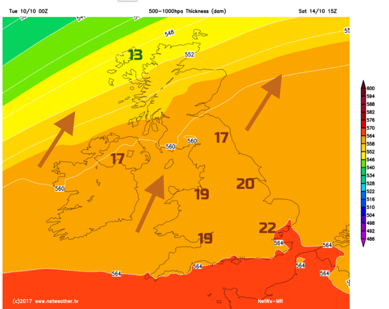
Overall this week will be mild, feeling warm in sheltered sunshine. Monday’s top temperature was 18C. This was above average and temperatures will continue to rise this week with 21 or 22C possible by Saturday in SE Britain. High pressure is building over the western Mediterranean and then much of western Europe. We stay to the north of the building high and so catch these weather fronts as low pressures move over the top. Yet we do begin to draw up warmer air from the south by the end of the week. There will be a bit of a blip midweek as one frontal system moves through on Wednesday. Behind that cold front, there will be a ridge of high pressure overnight so with clearer skies, and a brief draw of air from the NW, Wednesday night looks chilly. The next warm front is through on Thursday, so temperatures will climb by then. If the frontal band does get struck across the country, then Scotland, maybe Northern Ireland will stay cooler with a more N.Atlantic flow
The outlook for the rest of October, the Netweather Monthly forecast . Looking much milder than average for one part of the UK.
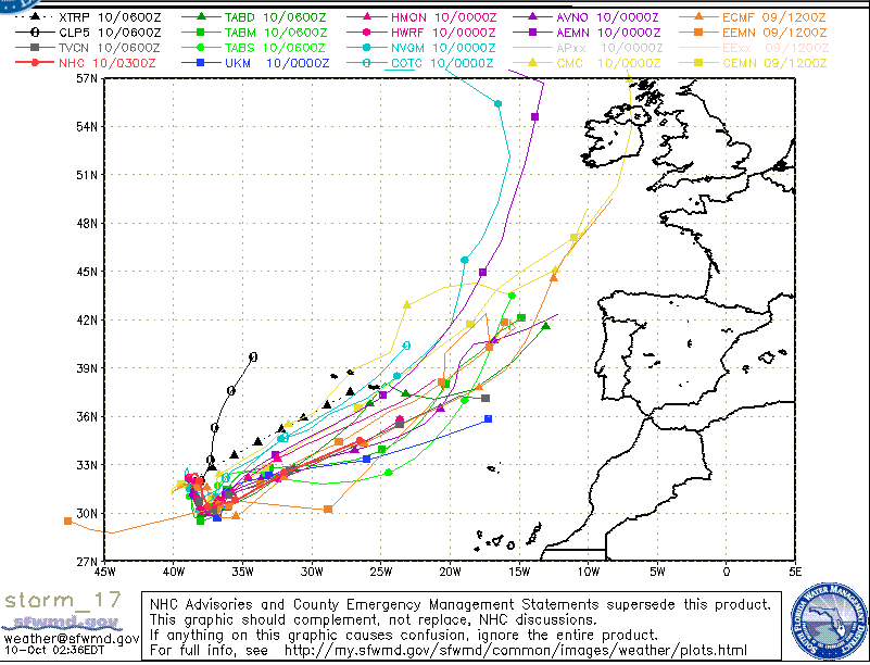
And an unusually situated Atlantic Tropical Storm, Ophelia, was TD17, could stir things up for the forecast models over western Europe.
The maximum daily temperature record for Oct 14th was 23.0C 73.4F Brooksby Hall (Leics) 1990. We could see near that this weekend.